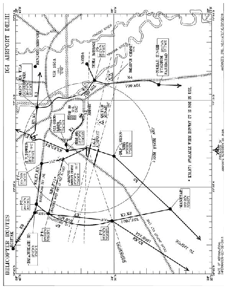
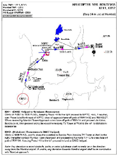
|
HEICOPTER VFR ROUTES
BANGALORE INTERNATIONAL AIRPORT
1. Helicopter VFR routings are established to stream line the movement of Helicopters operating to various destinations outside control zone of Bangalore International Airport (BIA) and also operating to various helipads within the control zone of BIA.
2. Conditions common to all procedures :
2.1 Helicopters shall operate on specified VFR Routes
2.2 During Special VFR conditions, these helicopter VFR routes shall be flown by pilots, having authorization in accordance with Civil Aviation Requirement (CAR) Section 8, Series O, Part I dated 6th September 2004 and with appropriate instrumentation on-board.
2.3 Helicopters will be manoeuvred at a speed that will provide adequate opportunity to observe other traffic or obstacle in time to avoid collision risk.
2.4 ATC may require helicopters to orbit or hold over any position/point due to traffic.
2.5 Helicopter will establish their position with reference to landmark given in the corridor and/or with reference to thefixes shown on the route map.
3. Conditions applicable for Operations in BIA Control zone:
3.1 If identification of Land mark is not feasible, the helicopter shall not enter within 5NM around the Bangalore
International Airport (BIA), remain clear of approach/Take off path of Runway-in-use and follow ATC instructions.
3.2 Helicopters will maintain 4000 ft on QNH of BIA when following the Helicopter VFR route(s), thereafter as
authorized by the respective ATC unit.
3.3 When flying on Helicopter VFR Routes, the terrain clearance is the responsibility of the pilot. If a manoeuvre is carried out by the pilot to avoid obstacle the pilot shall return to the assigned route as soon as clear of the obstacle.
3.4 The fixes defined by WGS-84 co-ordinates shall be flown and reported by pilots holding instrument ratings only.
3.5 Any deviation to avoid obstacle, traffic or wake turbulence/downwash shall normally be in the direction away
from Bangalore International Airport. If unable, such deviations shall be in co-ordination with BIA Tower.
3.6 Transponders of VFR flights inbound to BIA helipad via K027, should not be operated after waypoint KODIG, except when circumstances necessitate such use (Emergency, RCF and HIJACK) or when instructed by ATC.
3.7 Helicopters shall maintain two-way communication with Bangalore Approach while in its control zone and shall change over to other unit only when such authorization is given.
3.8 Helicopters, not suitably equipped with Navigation Equipments like GPS, VOR/DME etc. shall take alternate
clearance from BIA ATC before departure.
3.9 Operations at Jakkur aerodrome are subject to visibility prevailing at Jakkur and the operator shall obtain weather at the destination, before departure.
3.10 Helicopters shall remain in contact with ATS units within whose airspace jurisdiction it is flying, unless otherwise advised by ATS unit.
3.11 Helicopters shall pass their ETA of destination before 30 NM from Bangalore International airport.
3.12 All Radials and distances specified are with respect to “BIA” VOR (Latitude: 131224.63N, Longitude: 0774355.90E).
3.13 Helicopters intending to overfly Bangalore International Airport from North to south shall hold over Devanahalli Town remaining north of ASR RADAR antenna and shall maintain visual contact with aerodrome & traffic operating at BIA and shall be in VHF contact with BIA tower
3.14 Helicopters intending to overfly Bangalore International Airport from South to North shall hold visually south of control tower & Melanahalli (Inside the southern boundary of airport), shall maintain visual contact with aerodrome & traffic operating at BIA and shall come in VHF contact with BIA Tower when released by Yelahanka/HAL.
3.15 Helicopters operating from city helipads and HAL airport will join direct to nearest “VFR route Fix/Geographical point” and
then follow the Helicopter route as applicable.
|