AD 2 AERODROMES

VECC

VECC
AD 2.2

AERODROME GEOGRAPHICAL AND ADMINISTRATIVE DATA

1

Aerodrome reference point coordinates and its site

223914N 0882648E

01.75 DEG /1294M from THR 01R

2

Direction and distance of aerodrome reference point from the center of the city or town which the aerodrome serves

045 DEG/15KM from Howrah Railway Station

3

Aerodrome elevation and reference temperature

23 FT / 36.0 DEG C

4

Magnetic variation, date of information and annual change

0.50 DEG W (2010) /0.00

5


Name of aerodrome operator, address, telephone, telefax, e-mail address, AFS address, website (if available)

Airports Authority of India Netaji Subash Chandra Bose International

Airport, Kolkata -700052.,


Telephone:

+91-33-25119944

Fax:

+91-33-25118873

AFS:

VECCYUYU

Email:

apdkolkata@aai.aero

6

Types of traffic permitted (IFR/VFR)

IFR/VFR

7

Remarks

NIL

VECC

AD 2.3

OPERATIONAL HOURS

1

Aerodrome Operator

MON-FRI 0400-1230 UTC (0930-1800 IST)

Sat, Sun and Hol : Nil

2

Custom and immigration

H24

3

Health and sanitation

H24

4

AIS briefing office

H24

5

ATS reporting office (ARO)

H24

6

MET Briefing office

H24

7

Air Traffic Service

H24

8

Fuelling

H24

9

Handling

H24

10

Security

H24

11

De-icing

NIL

12

Remarks

The approved hourly runway traffic handling capacity is as follows:

1. Peak capacity when runway 19L/01R in use:

• Maximum number of Arrival and Departure- 35

• Maximum number of Arrival only - 23

• Maximum number of Departure only -23


2. During the period runway 19L/01R is taken for schedule maintenance i.e. when runway 19R/01L is in use:

• Maximum number of Arrival and Departure- 15

• Maximum number of Arrival only - 12

• Maximum number of Departure only -12

VECC

AD 2.4

HANDLING SERVICES AND FACILITIES

1

Cargo-handling facilities

Upto 12 Tons Handling Possible.

2

Fuel and Oil types

Avg 100LL, (ATF) JET A-1, MWM 45.55 MJOII

3

Fuelling facilities and capacity

(a) Hydrant At Prkg Stands 15-26 & 41-52.

(b) Bowzer At Dispersal Area Of Hanger 9,C1 & C2 , 1,000 Litres/ Min.

4

De-icing facilities

NIL

5

Hangar space for visiting aircraft

NIL

6

Repair facilities for visiting aircraft

Available For A321/A320 & B737-200 & ATR - 72 Type Of Aircraft, with Air India. Requiring Prior Arrangements

7

Remarks

1. Handling Services Available with Air India and Bhadra International. Requiring Prior Arrangements


2. All non-scheduled aircraft operators shall ensure availability of tow bar on board or availability of tow bar with their ground handling agent. Non-standard parking shall not be permitted for aircraft not having tow bar.


3. AVGAS 100LL not available for into plane service. On demand, AVGAS 100LL available against payment in barrels of 200LTRS. Methanol water mix, MWM not available.

VECC

AD 2.5

PASSENGER FACILITIES

1

Hotel(s) at or in the vicinity of aerodrome

Near The AD and in the city.

2

Restaurant(s) at or in the vicinity of aerodrome

At AD and in the city.

3

Transportation possibilities

Taxis, Buses from AD.

4

Medical Facilities

First aid at AD. Hospitals in the city.

5

Bank and post office at or in the vicinity of

aerodrome

Banks: At AD. Open H24.

Post office: At AD. Open H24.

6

Tourist office

At AD and in the City

7

Remarks

NIL

VECC

AD 2.6

RESCUE AND FIRE FIGHTING SERVICES

1

Aerodrome category for fire fighting

Within ATS HR: CAT-9

2

Rescue equipment

AVBL. as per category

3

Capability for removal of disabled aircraft

Available For Removal Of Up to B707 Type Of Aircraft

4

Remarks

NIL

VECC

AD 2.7

SEASONAL AVAILABILITY CLEARING

1

Type(s) of clearing equipment

NIL

2

Clearance priorities

NIL

3

Remarks

NIL

VECC

AD 2.8

APRONS, TAXIWAYS AND CHECK LOCATIONS/POSITIONS DATA

1

Designation, surface and strength of aprons

Refer Para VECC AD 2.23

2

Designation, width, surface and strength of

taxiways

Refer Para VECC AD 2.23

3

Location and elevation of altimeter checkpoints

NIL

4

Location of VOR checkpoints

NIL

5

Position of INS checkpoints

NIL

6

Remarks


VECC

AD 2.9

SURFACE MOVEMENT GUIDANCE AND CONTROL SYSTEM AND MARKINGS

1

Use of aircraft stand identification signs, taxiway guidelines and visual docking/parking guidance system at aircraft stands

For Aircraft stand identification sign & VDGS, Refer AD 2.23

Taxiway guideline marking available on all Taxiways.

Appropriate signages available.

2

Runway and taxiway markings and lights

RWY19L/01R Markings:

Designation, Aiming Point, THR, TDZ, Centreline, Side Strip, Chevron Marking, Runway Turn pad

RWY 19L Lights:

CAT-II Approach, Centreline, TDZ, THR, wing bar, RWY edge, RWY end.

RWY 01R Lights:

CAT-III B Approach, Centreline, TDZ, THR, wing bar, RWY edge, RWY end.

RWY19R/01L Markings:

Designation, Aiming Point, THR, TDZ, Centreline, Side Strip

RWY19R/01L Lights:

THR, RWY edge, RWY end.

TWY Markings:

Centreline, Edge, Holding Position, Fillet

TWY Lights:

Centreline lights on TWYs A, D, K, F1, F2, J1 & H1.

Edge lights on all taxiways

3

Stop bars (if any)

Available on TWY D, A & C.

4

Remarks

Runway Guard lights have been provided at CAT I holding positions on taxiways A, B, C and D and at 108M from Runway 19L centerline on taxiway K.


Intermediate Holding Position (IHP) lights have been provided on the following taxiways:

i. F1 Short of junction of F1, F2, H1, J1

ii. F2 Short of junction of F1, F2, H1, J1

iii. H1 Short of junction of F1, F2, H1, J1

iv. J1 Short of junction of F1, F2, H1, J1

v. A North of junction of A & D

vi. A South of junction of A & D

vii. A North of junction of A, H & H1

viii. A South of junction of A & H1

VECC

AD 2.10

AERODROME OBSTACLES

In Approach/Take-off/Circling Area and at AD

1

2

3

4

5

6

RWY/Area affected

Obstacle type

Coordinates

Elevation

Marking/LGT

Remarks

19R/TKOF

01L/APCH

TREE

223747.8N

0882637.4E

99 FT

NIL

TREE

19R/APCH

01L/TKOF

TREE

224006.4N

0882642.1E

75 FT

NIL

TREE

19L/APCH

01R/TKOF

TREE

224044.3N

0882658.3E

62 FT

NIL

TREE

19L/APCH

01R/TKOF

TREE

224045.9N

0882703.9E

59 FT

NIL

TREE

19L/APCH

01R/TKOF

TREE

224047.7N

0882700.0E

84 FT

NIL

TREE

19L/APCH

01R/TKOF

TREE

224048.7N

0882654.2E

89 FT

NIL

TREE

19L/APCH

01R/TKOF

TREE

224042.6N

0882653.5E

59 FT

NIL

TREE

19L/APCH

01R/TKOF

TREE

224047.2N

0882708.3E

78 FT

NIL

GP OF TREES

19L/APCH

01R/TKOF

OTHER

224049.1N

0882709.9E

79 FT

NIL

CHIMNEY

19L/APCH

01R/TKOF

TREE

224058.3N

0882707.7E

86 FT

NIL

TREE

19L/APCH

01R/TKOF

TREE

224059.1N

0882659.8E

89 FT

NIL

TREE

19L/APCH

01R/TKOF

TREE

224106.6N

0882705.3E

103 FT

NIL

TREE

19L/APCH

01R/TKOF

TREE

224053.0N

0882705.4E

103 FT

NIL

TREE

19R/TKOF

01L/APCH

TREE

223807.8N

0882635.9E

54 FT

NIL

TREE

19R/TKOF

01L/APCH

TREE

223811.4N

0882643.2E

47 FT

NIL

TREE

19R/TKOF

01L/APCH

TREE

223800.3N

0882637.7E

69 FT

NIL

TREE

19R/TKOF

01L/APCH

TREE

223813.1N

0882635.8E

57 FT

NIL

TREE

19R/TKOF

01L/APCH

TREE

223812.9N

0882639.4E

53 FT

NIL

TREE

19R/TKOF

01L/APCH

TREE

223816.0N

0882651.3E

52 FT

NIL

TREE

19R/TKOF

01L/APCH

TREE

223758.3N

0882629.8E

92 FT

NIL

TREE

VECC

AD 2.11

METEOROLOGICAL INFORMATION PROVIDED

1

Name of the associated meteorological office

AMO Kolkata

2

Hours of service and, where applicable, the designation of the responsible meteorological office outside these hours

H24

3

Office responsible for preparation of TAFs and periods of validity and interval of issuance of the forecasts

Kolkata

9, 30HR

4

Availability of the trend forecast for the aerodrome and interval of issuance

Trend

Trend Type landing forecast appended with each METAR / SPECI

5

Information on how briefing and/or consultation is provided

Provided, , through Documentation and OLBS


6

Types of flight documentation supplied and language(s) used in flight documentation

Chart And Tabular English

7

Charts and other information displayed or available for briefing or consultation

1. WAFC Products:

Data for upper wind & temperature for levels:

850 h.Pa, 700 h.Pa, 500 h.Pa, 300 h.Pa, 250 h.Pa, 200 h.Pa, 150 h.Pa, SIG Wx charts for FL 100 - 250 & for FL 250 - 630.

2. National Charts for consultation only.

Surface charts, synoptic upper air charts for levels: 100, 150, 200, 250, 300, 400, 500, 600, 700, 850 hPa, prognostic upper air charts at constant pressure, prognostic significant weather chart, DWR products / Satellite imagery.

8

Supplementary equipment available for providing information on meteorological conditions, e.g. weather radar and receiver for satellite images;

RS / RW Ascent, Transmissometer at TDZ 19L, TDZ 19R, MID 19L, TDZ 01R, MID 01R & END 01R, DCWIS at TDZ 19L & TDZ 01R, Radar & Satellite Picture


9

The air traffic services unit(s) provided with meteorological information

Kolkata ATC, ATS and ACC

10

Additional information, e.g. concerning any limitation of service.

Ceilometer at Runway 01R End operational .

VECC

AD 2.12

RUNWAY PHYSICAL CHARACTERISTICS

Designations


TRUE Bearings

Dimensions of RWY (M)

Strength of pavement

(PCN) and associated

data) and surface of runway and associated stopways

Geographical

coordinates for

threshold and

runway end

1

2

3

4

5

01L

6.25 DEG


70/F/B/W/T

Asphalt

THR:

223824.71N

0882638.37E

RWY END:


19R

186.25 DEG


70/F/B/W/T

Asphalt

THR:

223953.64N

0882648.82E

RWY END:


01R

6.25 DEG

3627 x 45 M

84/F/C/W/T

Asphalt

THR:

223831.91N

0882646.73E

RWY END:


19L

186.25 DEG

3627 x 45 M

84/F/C/W/T

Asphalt

THR:

224014.70N

0882657.80E

RWY END:


THR elevation

and highest

elevation of

TDZ of

precision APP

RWY

Slope of

runway and

associated

stopway

Dimensions of

stopway

(M)

Dimensions of

clearway

(M)

Dimensions of

strips

(M)

6

7

8

9

10

THR: 19.7FT

TDZ:

-0.02%

NIL

NIL

2823 x 150 M

THR: 19.0FT

TDZ:

-0.02%

NIL

NIL

2823 x 150 M

THR: 20.0FT

TDZ: 20.2FT


NIL

NIL

3956 x 300 M

THR: 19.0FT

TDZ: 19.8FT


NIL

NIL

3956 x 300 M

Dimensions of

runway end

safety areas

Location and

description of

arresting system

(if any)

Existence of an

obstacle-free

zone

Remarks.

11

12

13

14

130M x 90M


NIL

1. Dimension of RWY 01L: 3270M X 45M.

2. PCN from beginning RWY 01L upto 430M: 76/R/B/W/T, Surface: Concrete; PCN from 430 M upto 2830M: 70F/B/W/T, Surface Bitumen;

PCN from 2830M upto End of RWY: 101/R/C/W/T, Surface: Concrete

3. Slope : -.08% (769M) -.02% (1080M) +. 2% (550M)

135M x 90M


NIL

1. Dimension of RWY 19R: 2839M X 45M.

2.Threshold displaced by 90M

3.Slope: +. 2% (550M) -.02% (1080M) -0.08% (769M)

90M x 90M


NIL

NIL

240M x 90M


NIL

Threshold displaced by 427M NOTE: - To eliminate chance of RWY

surface damage Pilots to use Turn Pad of RWY 19L while lining up for departure.

VECC

AD 2.13

DECLARED DISTANCES

RWY Designator

Take-off

run

available

TORA

(M)

Take-off

distance

available

TODA

(M)

Accelerate

distance

available

ASDA

(M)

Landing

distance

available

LDA

(M)

Remarks

(including runway

entry or start point

where alternative

reduced declared

distances have

been declared)

1

2

3

4

5

6

01L

3270

3270

3270

2839


19R

2839

2839

2839

2749


01R

3627

3627

3627

3627


19L

3627

3627

3627

3200


VECC

AD 2.14

APPROACH AND RUNWAY LIGHTING

Runway

Designator

Type, length and

intensity of

approach lighting

system

Runway threshold

lights, colour and

wing bars

Type of visual

slope indicator

system

Length of runway

touchdown zone

lights

1

2

3

4

5

01L

SALS

420 M

Green

Wing Bar - NO

PAPI

LEFT/3.00 DEG

MEHT

(50.00FT)


19R

CAT I

900 M

LIH

Green

Wing Bar - No

PAPI

LEFT/3.00 DEG

MEHT

(50.00FT)


01R

900 M

CAT-IIIB

LIH

Green

PAPI

LEFT/3.00 DEG

MEHT

(50.00FT)

900 M

19L

CAT II

900 M

LIH

Green

PAPI

LEFT/3.00 DEG

MEHT

(50.00FT)

900 M

Length, spacing,

colour and

intensity of

runway centre line

lights

Length, spacing,

colour and

intensity of

runway edge lights

Colour of runway

end lights and

wing bars

Length and colour

of stopway lights

Remarks

6

7

8

9

10


3270 M

60 M

Variable white

LIH

Red


1. APCH with cross bar at 300M.


2839 M

60 M

Variable white

LIH

Red


1. Last 600M of runway edge lights amber.

3627 M

15 M

LIHVariable White

3627 M

60 M

Variable white

LIH

Red


1. Runway Centreline lights Last 900m to 300m from RWY end alternate red & variable white Red for last 300m from RWY end

2. Last 600M of Runway Edge lights amber.

3627 M

15 M

LIHVariable White

3627 M

60 M

Variable white

LIH

Red


1. RWY Centreline lightsLast 900m to 300m from RWY end alternate red & variable white Red for last 300m from RWY end

2. Last 600M ofrunway edge lights amber.

3. Inset Turn Pad Lights on Runway 19L Available InSingle Circuit with Turn Pad Edge Light

VECC

AD 2.15

OTHER LIGHTING, SECONDARY POWER SUPPLY

1


Location, characteristics and hours of operation of aerodrome beacon/identification beacon (if any)

ABN

Installed on the top of ATC tower;

Beam colour- Green & White; 24-30 flashes per minutes;

H-24

H24

IBN

NIL

2


Location and lighting (if any) of anemometer/landing direction indicator;

LDI

Available WDI Not Available

Anemometer

1. 390 M from THR19L,

Lighted

2. 300 M from THR01R,

Lighted

(Both 1&2 located North of

RWY 19L / 01R)

3


Taxiway edge and taxiway centre line lights;

Edge

ALL TWYs

Centre Line

ON TWYs A,D, K, F1, F2, J1 & H1

4

Secondary power supply including switch-over time;

Secondary power supply to all air field lighting.

Switch-over time : CAT-I 15 SEC CATII/IIIB 1 sec.

5

Remarks


VECC

AD 2.16

HELICOPTER LANDING AREA

1

Geographical coordinates of the geometric centre of touchdown and lift-off (TLOF) or of each threshold of final approach and take-off (FATO) area

Not Established

2

TLOF and/or FATO area elevation:

Not Established

3

TLOF and FATO area dimensions to the nearest metre or foot, surface type, bearing strength and marking;

Not Established

4

True bearings of FATO;

Not Established

5

Declared distances available

Not Established

6

Approach and FATO lighting;

Not Established

7

Remarks

Not Established

VECC

AD 2.17

AIR TRAFFIC SERVICE AIRSPACE

1

Airspace designation, geographical

coordinates and lateral limits

CTR: Circular area centered on ARP VECC (223914N 0882648E) within a 25NM radius.

2

Vertical limits

FL 50

3

Airspace classification

D

4

Call sign and language(s) of the air

traffic services unit providing service;

Kolkata Tower, English

5

Transition altitude

4000 FT

6

Hours of applicability

H24

7

Remarks

Airspace from 4000 FT AMSL and above is Classified as Class ‘C’.

VECC

AD 2.18

AIR TRAFFIC SERVICES COMMUNICATION FACILITIES

Service Designation


Call sign


Channel(s)


SATVOICE Number(s),

if available


1

2

3

4

TAR

Kolkata Radar

119.300 MHZ


TAR

Kolkata Radar

127.900 MHZ


SAR

-

123.100 MHZ


APP

Kolkata Approach

119.300 MHZ


APP

Kolkata Approach

127.900 MHZ


TWR

Kolkata Tower

118.025 MHZ


TWR

Kolkata Tower

118.100 MHZ


ATIS

Kolkata Information

126.400 MHZ


ALRS

---------

121.500 MHZ


RADAR

Kolkata Radar

120.100 MHZ


RADAR

Kolkata Radar

120.700 MHZ


RADAR

Kolkata Radar

125.900 MHZ


RADAR

Kolkata Radar

126.100 MHZ


RADAR

Kolkata Radar

132.450 MHZ


SMC

Kolkata Ground

121.725 MHZ


SMC

Kolkata Ground

121.900 MHZ


Logon

address, as

appropriate

Hours of operation


Remarks


5

6

7


H24

SDBY


H24

NIL


International Voice SAR On Scene Frequency 123.1MHZ Is Operational


H24

SDBY


H24

NIL


H24

NILSDBY FREQ


H24

NIL


H24

NIL


H24

EMERGENCY FREQUENCY


H24

NIL


H24

NIL


H24

SDBY


H24

SDBY


H24

NIL


SDBY FREQ


H24

NIL

VECC

AD 2.19

RADIO NAVIGATION AND LANDING AIDS

Type of aids, magnetic variation and type of supported operation for ILS/MLS, basic GNSS, SBAS and

GBAS, and for

VOR/ILS/MLS station

used for technical lineup of the aid

Identification

Frequency(ies),

Channel number(s),

Service provider, and

reference path

identifier(s) (RPI), as

appropriate

Hours of operation, as

appropriate;

1

2

3

4

LOC 01R

ICAL

109.900 MHz

H24

LOC 19L

IDUM

110.300 MHz

H24

LOC 19R

IOKL

111.300 MHz

H24

GP 01R

ICAL

333.800 MHz

H24

GP 19L


335.000 MHz

H24

GP 19R

IOKL

332.300 MHz

H24

DME ILS 01R

ICAL

CH36X

H24

DME ILS 19L

IDUM

CH40X

H24

DME ILS 19R

IOKL

CH50X

H24

DVOR/DME

CEA

112.500 MHz

CH72X

H24

L

CA

293.000 kHz

H24

L

DU

385.000 kHz

H24

Geographical

coordinates of the

position of the

transmitting

antenna

Elevation of

transmitting

antenna of

DME/

elevation of

GBAS

reference point

Service volume radius

from the GBAS

reference point

Remarks

5

6

7

8

224040.8N

0882701.9E


223818.1N

0882644.7E


223801.6N

0882635.7E


LLZ inner coverage is restricted to 30 DEG on 150HZ side, no restriction on

90HZ side.

223841.8N

0882652.1E


3 DEG

224004.0N

0882701.5E


3 DEG

223943.5N

0882643.3E


3 DEG

223841.8N

0882652.1E

48 FT


Colocated with GP 01R 3 DEG

224004.0N

0882701.5E

62 40 FT


Colocated with GP 19L

223943.5N

0882643.3E

48 FT


Collocated with GP 19R

224033.5N

0882653.3E

49 FT


223501.6N

0882623.8E


Locator ILS 01R

224424.6N

0882727.4E


Locator ILS 19L

VECC

AD 2.20

LOCAL AERODROME REGULATIONS

1I. For Stand 15, 16 & 17 Taxi in via TWY G& Taxi out via TWY A.


2II. For parking stands 52 & 53 manual marshalling required. Departing aircraft to push back on TWY F1facing north and start engines only after reaching abeam stand No.51


3III. Portion of TWY ‘F1’ from the rear of stand 50 to the intersection of TWY ‘R’ available for operations of ACFT. Up to CAT C. Necessary guidance board, lights and markings provided.


4IV. Portion of TWY ‘R’ from the intersection of TWY ‘A’ till intersection of TWY ‘F1” available for aircraft upto CAT C. During towing to hanger exercise caution due presence of vehicles.


V. AIRPORT COLLABORATIVE DECISION MAKING (A-CDM, KOLKATA)


1. BACKGROUND

1.1 The NSCBI Airport, Kolkata - Collaborative Decision Making (A-CDM, Kolkata) undertaken at NSCBI Airport is a joint

programme among all airport partners -

• Air Navigation Service Provider (ATC)

• Aircraft Operators (AO)

• Airport Operator (AOCC)

• Ground Handling Agencies (GHA)

• Central Air Traffic Flow Management Unit (CATFMU)*

• Air Force Movement Liaison Unit (AF-MLU)

All the partners are required to work in close collaboration to ensure the successful operation of A-CDM, Kolkata.


1.2 The efficiency of the Air Transport System is highly dependent on traffic predictability. A-CDM, Kolkata effectively enhances predictability (this reduces buffer times for resource planning and flight times), overall efficiency and punctuality by linking and sharing of accurate and timely information amongst Aircraft Operators, Airport Operator, ATC, etc.

1.3 A-CDM application is developed in-house by Airports Authority of India.
 
1.4 A-CDM system processes and utilizes the following information from the various sources mentioned below:
a) AFTN:
i) Flight plan data
ii) EOBT
iii) ATD
iv) ETAs
v) NOTAMs
vi) METARs
vii) ADC Numbers
b) Airport Operations Data Base (AODB) of Kolkata
i) Parking stand of Aircraft
ii) Registration marking
iii) Boarding status of departing aircraft
iv) Actual “Off Block” Times
v) Actual “In-Block” Times
c) A-CDM system database
i) Arrival and Departure Taxi timings from each parking stand
ii) Runway-in-Use and Closures
iii) Hourly handling capacity of runways
iv) Priority of flights e.g. VVIP and Emergencies etc.
v) Flight schedules
 
1.5 A-CDM is a Common Information Sharing Platform introduced to process timely and accurate information for quick and precise decision making. A-CDM takes into consideration the ETAs of arriving aircraft, Target Off Block Times of departures, Runway-in-use and the handling capacity of the runway and determines the arrival and departure sequence. Based on the sequence and the parking position, it calculates the Target Take-Off Times & Target Start up Times of departures and Target In-Block Times for arrivals.
 
1.6 Implementation of ACDM will result in considerable benefits to stakeholders. The various benefits of A-CDM includes are as follows:
• Improvement in efficiency of operations
• Reduction of delays to departures at holding point.
• Orderly flow of traffic.
• Reduction in wastage of Aviation fuel.
• Reduction in Carbon Emission, reduction in Environmental Pollution.
• Optimization of airport and airspace capacity Reduction of R/T congestion
• Enhancement of safety due to reduced R/T congestion.
• Better Situational Awareness and increased confidence amongst ACDM Partners.
• Adherence to ADC (Air Defence Clearance) by stake holders.
• Better Passenger experience.
• Optimized use of ground handling resources
• Optimized use of parking stands, gates and terminals.
• Reduced apron and taxiway congestion
• Access to current MET information.
 
2. TWO KEY PARAMETERS OF A-CDM, Kolkata: TOBT and TSAT
2.1 TARGET OFF-BLOCK TIME (TOBT)
2.1.1 Definition: The time that an Aircraft Operator estimates that an aircraft will be ready, all doors closed, boarding bridge removed, push back vehicle available and ready to start up/push back immediately upon reception of clearance from the SMC (GROUND). It is the real time target of ensuring readiness of an aircraft and therefore, more accurate than the static departure time mentioned in the flight plan and hence, an ideal milestone to be used by all airport partners.
 
2.1.2 Purpose: Air Traffic Management (ATM) based on only FPL-data is insufficient to guarantee smooth and efficient operations on the ground and in the air. The main reason for this is the incorrect updating/no updating at all, of the Estimated Off Block Time (EOBT) of the aircraft. The result is that airport partners will have an incorrect idea about the actual status of that specific aircraft. The purpose of Target Off-Block Time (TOBT) is to provide a timely, accurate and reliable estimate of an aircraft's off block time to the A-CDM, Kolkata partners. Accurate TOBTs enhance operations on the ground as they provide all airport partners with a clear picture of the intentions of aircraft on the ground.
 
2.1.3 Communication of TOBT: Aircraft Operators shall revise their EOBTs via AFTN using CHG/ DLA message or inform ARO for revised EOBT, who in turn will originate CHG / DLA message for transmission through AFTN.
 
2.1.3.1 In case No delay is expected: If there is no revision of EOBT, EOBT will be treated as the TOBT. For such cases there is no need of any communication from the Aircraft Operator to the ARO.
 
2.1.3.2 In case delay is expected:
 
a) When Air Defence Clearance (ADC) is valid: If delay is within the validity period of ADC, EOBT should be
revised through CHG/DLA message. Optionally TOBT can be changed in ACDM interface. But if due to some
reason coordination is not possible by both the above methods then EOBT can be revised by informing ARO/MCD.
b) When Air Defence Clearance ADC is NOT valid:
i) If delay is outside the validity period of ADC, EOBT shall be revised through CHG/DLA message or after
having coordinated with MLU and obtaining the revised ADC number, by informing ARO/MCD about
revised EOBT and ADC. (Option of change of TOBT will not be available in this case).
ii) ADC Validity Period: (-) 15 minutes to (+) 45 minutes of EOBT in RPL/FPL or subsequent revision of EOBT
by DLA/CHG message.
Note: Once Target Start-up Approval Time (TSAT) is allocated by ATC at TOBT - 30 minutes, the TOBT can be
updated thrice.
 
2.1.4 Accuracy: TOBTs must be updated to an accuracy of +/- 5 minutes.
2.2 TARGET START UP APPROVAL TIME (TSAT)
2.2.1 Definition: The time is calculated by A-CDM application taking into account TOBT, CTOT* and/or the traffic situation that an aircraft can expect to start-up/push back for departure.
Note: In case there is no congestion, ATC may allow the aircraft to start, where Actual Start-up Approval Time
(ASAT) will be before the TSAT.
 
2.2.2 Purpose: TSATs provide an optimized start-up sequence, leading to Pre-Departure sequence. TSATs reduce queuing times at the runway holding points, while ensuring optimised utilisation of the runway. ATC will continue to optimize the departure order for creating the right mix of traffic.
 
2.2.3 Calculation of TSAT: TSAT is calculated automatically by A-CDM Application. The TSAT is calculated by taking into account TOBT, priority of aircraft, variable taxi times, and the runway capacity. Any revision of EOBT will trigger the A-CDM application to recalculate a new TSAT for that flight as well as to re-allocate earlier TSAT to next flight which meets the requisite conditions. TSAT is displayed in various ACDM interfaces in the following colour coded information.
Blue colour: TSAT -15 minutes up to TSAT -5 minutes’ Green colour: TSAT -5 minutes up to TSAT +5 minutes Red colour: After TSAT +5 minutes.
 
2.2.4 Generation of TSAT: TSAT is generated by ACDM interface at TOBT - 30 minutes.
 
2.2.5 Communication of TSAT: TSAT will be displayed in various A-CDM interfaces. The AO/GHA shall advise flight crew of TSAT, displayed in the A-CDM interface.
 
2.2.6 Priorities for generation of TSAT:
The following aircraft will be accorded priority by A-CDM application at the time of generating TSATs:
a) VVIP flights
b) Aircraft in emergency
c) Ambulance aircraft
d) Aircraft in relief missions
e) Aircraft returning to stand after push back/taxiing out for any reason.
 
2.2.7 Airlines/GHAs are required to monitor the A-CDM interface regularly to get information on the revised TSAT if any, in respect of their aircraft. It may please be noted that the earlier allocated TSAT may get changed due to the following reasons:
i) Change of runway
ii) Change in taxi times
iii) Revised TOBT of the subject aircraft
iv) Cancellation/ revision in TOBT of other aircraft in the departure sequence.
v) Priority handling
vi) Unusual Occurrences, etc.
vii) Change of aircraft type*
viii) Application of ATFM regulation or ATC restriction resulting in new CTOT or start up delay*
ix) Inclement Weather*
x) Bird activity*
xi) Change of route (SID)*
 
2.2.8 Accuracy: The TSAT will remain valid for +/- 5 minutes.
 
3 Co-ordination with the Central Air Traffic Flow Management Unit (CATFMU)*
3.1 A permanent and fully automatic data exchange with the ATFMU will be established. The data transfer will enable highly accurate early predictions of landing and departure times. *
 
3.2 Furthermore, it allows for more accurate and efficient CTOT calculations due to the use of more accurate local target take-off times. *
 
4 TOBT and TSAT based A-CDM, Kolkata Start-up/Push-back procedures
4.1 Pre-Departure Sequence: Pre-Departure sequence is the order, in which the ATC plans the aircraft to depart from their Gate/Stands. It should not be confused with the Pre-Take-off sequence where ATC decides on the order in which the aircraft at holding points of the runway will depart.
 
4.2 Start-Up and Push-Back Procedure:
i. The pilot will contact Clearance Delivery (CLD) to request en-route clearance and SID between TSAT - 15
minutes to TSAT - 5 minutes. Blue Zone.
ii. The aircraft must be ready to Start-up/Push-back at TOBT and request SMC (GROUND) for Start-up/Push-
back at TSAT - 5 minutes and TSAT + 5 minutes. Green Zone.
(Note: The system may prepone TSAT up to TOBT)
iii. In case for Schedule Flight, “Boarding” has not started at or before TSAT - 5 Minutes, allotted TSAT will be
cancelled and associated slot will be allocated to next eligible aircraft.
a. A new TOBT is required from Airlines Operator.
b. On receipt of new TOBT, the flight will be re-sequenced according to new TOBT and a new TSAT with a subsequent
delay will be issued.
iv. If at TSAT +5 minutes: Red Zone, ATC has not received Start-up/Pushback request, the aircraft will lose its
position in sequence.
a. A new TOBT is required from Airlines Operator.
b. On receipt of new TOBT, the flight will be re-sequenced according to new TOBT and a new TSAT with a subsequent
delay will be issued.
v. ATC should normally be able to issue start-up/push-back at TSAT. Pilots will be informed by ATC of any revised
TSAT if there is a delay to TSAT in excess of 5 minutes.
vi. Taxi clearance must be requested within 5 minutes of Start-up/Pushback approval time.
(Note: If this has not occurred, SMC (GROUND) must be notified of the extent of delay. In such cases, aircraft may
lose its departure slot and a new TOBT may be required in A-CDM, Kolkata interface. AO shall be responsible to
obtain new ADC number from IAF-MLU).
vii. The Pre-Departure (Off- block) Sequence will be determined in accordance with Target Start up Approval Time
(TSAT) and NOT in accordance with the Start-up Request. Pre-Departure Sequence will not have any bearing on
Actual Departure sequence.
(Note: Actual Departure sequence may differ from pre-departure sequence in order to optimize the Runway and
Airspace utilization.)
* [Future provision kept for incorporating with India - Central Air Traffic Flow Management]
 
5 TERMS AND ABBREVIATIONS
All Acronyms are time parameters which have a standard length of four characters and have been arranged as per
aircraft movement sequence.
[While developing the A-CDM, Kolkata procedures, the guidance material published by Euro control, ICAO A-CDM and
other Organizations has been used].
S.
NO.
ACRONYMS
DEFINITION
EXPLANATION
5.1
ELDT
Estimated Landing
Time
The estimated time that an aircraft will touchdown on the runway. (Equivalent to ATC ETA = Estimated Time of Arrival = landing).
5.2
ALDT
Actual Landing
Time
The time that an aircraft lands on a runway. (Equivalent to ATC ATA = Actual Time of Arrival = Landing, ACARS = ON).
5.3
EXIT
Estimated Taxi- In
Time
The estimated taxi time between landing and inBlock.
5.4
AXIT
Actual Taxi-In
Time
AXIT = AIBT - ALDT
5.5
SIBT
Scheduled InBlock Time
The time that an aircraft is scheduled to arrive at its first parking position.
5.6
EIBT
Estimated InBlock Time
The estimated time that an aircraft will arrive inblocks.
(Equivalent to Aircraft Operator’s ETA = Estimated Time of Arrival).
5.7
AIBT
Actual In-Block
Time
The time that an aircraft arrives in-blocks. (Equivalent to Aircraft Operator’s ATA = Actual Time of Arrival, ACARS = IN).
5.8
STTT
Scheduled
Turnaround Time
STTT = SOBT - SIBT
5.9
ETTT
Estimated
Turnaround Time
The time estimated by the AO/GH on the day of operation to turnaround a flight taking into account the operational constraints.
5.10
MTTT
Minimum
Turnaround Time
The minimum turnaround time agreed with an AO/GH for a specified flight or aircraft type.
5.11
ATTT
Actual
Turnaround Time
ATTT = AOBT - AIBT
5.12
ASRT
Actual Start Up
Request Time
Time the pilot requests start up clearance.
5.13
TSAT
Target Start Up
Approval Time
The time provided by ATC taking into account TOBT, CTOT* and/or the traffic situation that an Aircraft can expect start-up / push back approval. Note: The actual start up approval (ASAT) can be given in advance of TSAT.
5.14
ASAT
Actual Start Up
Approval Time
Time that an aircraft receives its start-up approval.
5.15
SOBT
Scheduled OffBlock Time
The time that an aircraft is scheduled to depart from its parking position.
5.16
EOBT
Estimated OffBlock Time
The estimated time at which the aircraft will start movement associated with departure (ICAO)
5.17
TOBT
Target OffBlock Time
The time that an Aircraft Operator estimates that an aircraft will be ready, all doors closed, boarding bridge removed, push back vehicle available and ready to start up / push back immediately upon reception of clearance from the SMC (GROUND).
5.18
AOBT
Actual OffBlock Time
Time the aircraft pushes back / vacates the parking position. (Equivalent to Aircraft Operator’s ATD = Actual Time of Departure & ACARS = OUT)
5.19
ARDT
Actual Ready
Time
(for Movement)
When the aircraft is ready for start-up/push back or taxi immediately after clearance delivery, meeting the requirements set by the TOBT definition.
5.20
EXOT
Estimated TaxiOut Time
The estimated taxi time between off-block and take off. This estimate includes any delay buffer time at the holding point prior to take off.
5.21
AXOT
Actual Taxi-Out
Time
AXOT = ATOT - AOBT
5.22
ETOT
Estimated Take
Off Time
The estimated takeoff time taking into account the EOBT plus EXOT.
5.23
CTOT*
Calculated Take
Off Time*
A time calculated and issued by the appropriate Central Management unit, as a result of tactical slot allocation, at which a flight is expected to become airborne. (ICAO Doc 7030/4 - EUR, Table 7)*
5.24
TTOT
Target Take Off
Time
The Target Take Off Time taking into account the TOBT/TSAT plus the EXOT. Each TTOT on one runway is separated from other TTOT or TLDT to represent vortex and/or SID separation between Aircraft.
5.25
ATOT
Actual Take Off
Time
The time that an aircraft takes off from the runway. (Equivalent to ATC ATD = Actual Time of Departure, ACARS = OFF).

VECC

AD 2.21

NOISE ABATEMENT PROCEDURES

Consistent with safety of aircraft operations and in consideration of high intensity runway operations, pilots should minimize the use of reverse thrust after landing to reduce disturbance in areas adjacent to the aerodrome.

VECC

AD 2.22

FLIGHT PROCEDURES

I. Kolkata TMA Routing

Route Designator

Kolkata TMA Routing

P646

DOPID N205503.2 E 0891216.1 - 339 DEG/112NM ---CEA VOR N223842.6 E0882710.4

M773

BUBKO N191103.7 E0883950.5 - 349 DEG/151NM --

LEGOS N213802.9 E0880520.6 - 019 DEG/064NM

--- CEA VOR N223842.6 E0882710.4

II. SURVEILLANCE RADAR APPROACH PROCEDURES


i. NSCBI AIRPORT, KOLKATA

RWY

THR

ELEVATION

(FT)

Inbound

Track

DEG

(M)

IF (Dist.

From

touch down)

(NM)

Altitude

over IF

(FT)

FAF (Dis.

From

touch down

(NM)

Altitude

over FAF

(FT)

MAPT (Dist.

From

touch down)

(NM)

OCA

(Straight-in)

(FT)

19 L

19

187

12

2000

6.2

2000

2

660

01 R

20

007

12

2000

6.2

2000

2

670

ii. Distance / Altitude Information

RWY

Dist. from TD

(NM)

Distance / Altitude Information (NM)

Descent Gradient

(GP Angle)

6

5

4

3

2

19L

Altitude (Ft)

1940

1620

1300

980

660

5.26% (3 Deg)

01R

Altitude (Ft)

1940

1620

1300

980

670

5.26% (3 Deg)

iii. OCA Circling:


CAT A/B: 720 ft.

CAT C/D: 820 ft.


iv. Missed Approach Procedure:


RWY 19L: Climb straight ahead to 2000 ft then turn left to join VOR holding as specified in Para 6 or as instructed by ATC.

RWY 01R: Climb straight ahead to 2000 ft then turn right to join VOR holding as specified in Para 6 or as instructed by ATC.


v. Radar vectoring Areas:


Radar vectoring area is 2000 ft AMSL in all the sectors up to 25 NM.


vi. Holding procedure VOR (112.5 CEA)


RWY 19L One-minute right hand pattern inbound track 003 DEG M. Minimum holding altitude 2000ft.

RWY 01R One-minute left hand pattern inbound t rack 205 DEG M. Minimum holding altitude 2000ft.


vii. Radio communication failure procedure:


a. In case radio communication failure takes place prior to establishing final approach, maintain the last assigned altitude or 2000ft whichever is higher and proceed to VOR (112.5) CEA via the shortest route to join holding procedure as specified in para vi

b. In case radio communication failure takes place after establishing the final approach track, aircraft may continue the approach and land if visual, or go around and carry out the missed approach procedure and join the VOR (112.5) CEA holding procedure as specified in Para 6.

c. After joining the VOR holding procedure commence the instrument approach procedure (ILS or VOR) for RWY for which SRA was being provided.

d. If required by ATC the length of intermediate segment may be reduced to less than 5NM but not less than 2NM provided angle of interception does not exceed 30 Deg.

III. RADIO COMMUNICATION FAILURE PROCEDURES:


1. INTRODUCTION:


The Radio Communication Failure procedures established herein are based on the provisions of ICAO PANS ATM DOC 4444. The objective is to standardize the actions to be taken by the pilot of arriving and departing aircraft experiencing radio communication failure at Kolkata airport, when ATS surveillance system is used in the provision of air traffic control in such airspace.

During the periods of non-availability of ATS surveillance system in part or whole of the concerned airspace in Kolkata, the provisions of ICAO PANS ATM DOC 4444 shall be followed.


2. SCOPE:


The procedures in this document shall be applicable to the pilots of arriving and departing aircraft experiencing radio communication failure at Kolkata airport when ATS surveillance system is used in the provision of air traffic control in such airspace.


3. GENERAL:


3.1 All Transponder equipped aircraft experiencing Radio Communication Failure shall set transponder to Mode A/C code 7600 as soon as practicable. (Note: This Requirement of Setting transponder to Mode A/C code 7600 in no way imposes any restriction on the pilot’s decision to set transponder to Mode A/C code 7500 or 7700, whenever required).


3.2 An aircraft equipped with other surveillance system transmitters, including ADS-B and ADS-C, might indicate the loss of air-ground communication by all of the available means.


3.3 Aircraft equipped with CPDLC should log on to Kolkata Data-link (ADS-CPDLC) VECF, so that CPDLC connection may be established for communication.


3.4 To indicate that it is experiencing Radio Communication Failure, an aircraft equipped with ADS-C shall transmit appropriate message in this regard.


3.5 Immediately after detection of RCF, the pilot shall try to communicate to the concerned ATS unit through the frequencies of adjacent units/stations, or 121.5 MHz or by relay through other aircraft. The RCF aircraft shall also try to contact the appropriate HF frequencies to relay messages to the concerned ATS unit.


3.6 Aircraft shall avoid all Restricted Areas and active Danger Areas. Aircraft shall not enter Bangladesh airspace if flight plan does not include Dhaka FIR unless emergency conditions warrant so. If aircraft is observed entering any of the areas mentioned above concerned ATC unit shall inform the units concerned accordingly.


3.7 Pilot shall make blind transmission to ATC of all necessary reports and actions taken by the aircraft, e.g. descent, turn, proceeding to waypoint etc., irrespective of whether partial/ complete RCF has been established or not.

4. ASSIGNED RUNWAY AND ITS AVAILABILITY FOR RCF AIRCRAFT:


4.1 In case of an arriving aircraft experiencing RCF, when Runway for landing has already been advised to the aircraft by ATC, such runway shall be considered as the assigned runway. If an arriving aircraft has not been advised of any runway, Runway 19L shall be considered as assigned runway for such arrival. During the notified periods of maintenance/closure of Runway 19L, Runway 19R shall be considered as assigned Runway and vice-versa.


4.2 In case of departures from Kolkata returning due to RCF, the departure runway of such aircraft shall be considered as assigned runway for landing.


4.3 Runway lights and Approach lights in ‘SWITCHED ON’ position shall indicate the availability of such Runway for aircraft experiencing RCF.


4.4 Irrespective of visibility/weather conditions, Runway and Approach lights in ‘SWITCHED OFF’ position shall indicate non-availability of such Runway for aircraft experiencing RCF.

In such cases, alternate runway shall be made available for such aircraft. Runway 19R shall be alternate to Runway 19L and Runway 01L shall be alternate to Runway 01R. Similarly, Runway 19L shall be alternate to Runway 19R and Runway 01R shall be alternate to Runway 01L.


4.5 In case strong tail wind conditions are encountered during approach for the assigned Runway, the aircraft experiencing RCF will carry out a missed approach on assigned runway and after following complete missed approach procedure for such approach, aircraft will carry out the published ILS/VOR approach procedure for the runway which is in opposite direction to the assigned Runway, e.g. Runway 01R in case of assigned Runway 19L.


5. PROCEDURE FOR ARRIVALS:


5.1 General:


a. Except when descent clearance has already been received from ATC and acknowledged, pilot shall not commence descent before 100 NM from CEA VOR or until three minutes after setting Mode A/C code 7600 whichever is later.

b. In case radio communication failure takes place after establishing ILS/ final approach track, aircraft may continue the approach and land if visual, or go around and carry out the missed approach procedure and join the VOR (112.5) CEA holding procedure climbing to and maintaining 2000 FT.


5.2 Arriving Aircraft - STAR Assigned


When STAR has been assigned to an arrival experiencing radio communication failure, it shall:

a. Continue on the assigned STAR following all level and speed restrictions applicable to STAR, as far as practicable.

b. Commence descent as in Para 5.1(a) above. Descend to FL70.

c. At the end of the STAR, descend to 2000ft and take a suitable turn to intercept localizer or final approach track of the published procedure for the assigned runway, remaining within 25 NM of CEA.

d. If additional track miles are required to adjust descent, hold across the final approach track of the assigned runway between 15 and 25 NM from CEA.


5.3 Arriving Aircraft - STAR Not Assigned


When STAR has not been assigned to an arrival experiencing radio communication failure, it shall:

a. Continue on ATS route, (re-join ATS route if given heading or flying offset)

b. Commence descent as in Para 5.1 (a) above. Descend to FL70 and proceed to CEA VOR.

c. Descend in CEA hold to 2000ft and carry out the published ILS/VOR approach procedure for the assigned runway.


5.4 Arriving Aircraft Being Radar Vectored


An aircraft which is radar vectored, on experiencing radio communication failure, shall:


a. Maintain the last assigned speed, level and heading for 3 minutes after selecting MODE A/C 7600.

b. Then proceed direct to CEA VOR descending to FL70 according to Para 5.1 (a) above.

c. Descend in CEA hold to 2000 FT and carry out the published ILS/VOR approach procedure for the assigned runway.

6. PROCEDURE FOR DEPARTURES:


6.1 Departure Intending to Continue to Destination


A departing aircraft experiencing radio communication failure and intending to continue to its filed plan destination shall:


a. Continue on the assigned SID or heading, climbing to/ maintaining cleared and acknowledged level or FL60, whichever is higher.

b. Three minutes after setting Mode A/C code 7600 or reaching FL60 or cleared Flight level (if higher than FL60) whichever is later:


i. if following SID, continue on SID to join ATS route and climb to filed Flight level and continue as per the filed flight plan.

ii. if following Radar heading or have been directed by ATC to proceed offset using RNAV without a specified limit, proceed in the most direct manner possible to re-join the current flight plan route no later than the next significant point, maintaining cleared flight level/FL60 whichever is higher. After joining ATS route, climb to filed Flight level and continue as per the filed flight plan.


6.2 Departure Intending to Land Back at Kolkata:


A departing aircraft, experiencing radio communication failure and intending to land back under VMC at Kolkata Airport in accordance with provisions of DGCA CAR Series C part I, shall:

a. Continue on assigned SID or radar heading and set Mode A/C code 7600.

b. Climb/ stop climb at a level according to the table given below:

Phase of flight

Actions to be followed by pilot

At or below FL70

Maintain/Climb to FL70

Above FL70, but below FL230

Maintain/ Climb to:

The last cleared and acknowledged level or FL230/ FL220, (appropriate to the direction of the flight) whichever is lower.

At or above FL230

Stop climb at the next level appropriate to the direction of the flight.

c. On reaching a suitable level according to Para 6.2 (b) above, or three minutes after setting Mode A/C code 7600, whichever is later, take a suitable turn to establish inbound the same ATS route and proceed to CEA VOR. After establishing the inbound track, descend as mentioned in Para 6.2 (d) or 6.2 (e) below.


d. At 50NM descend to FL70, if jettisoning is not necessary.


e. In case the aircraft needs to jettison fuel, it shall:


i. Climb/descend to FL100. Proceed outbound on R-170 CEA VOR until 80NM.

ii. Hold at FL100 between R-160 and R-180 CEA VOR, 80 and 100 NM from CEA DME to jettison fuel.

iii. On completion of jettisoning return to CEA VOR via R-170 CEA VOR. At 50NM inbound descend to FL70 and subsequently follow the provisions of Para 6.2 (f) below.


f. Descend in CEA hold to 2000 FT and leave CEA VOR to carry out the published ILS/VOR approach procedure for the assigned runway.

VECC

AD 2.23

ADDITIONAL INFORMATION
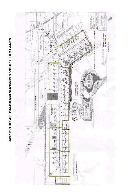
I PARKING STANDS
CARGO APRON
Aircraft Stand
No.
Surface
PCN
Co-ordinates
Suitablility
Type
Parking
guidance
Fuel
Hydrant
C1
CONCRETE
90/R/C/W/T
223909.48N 0882632.73E
B737-200
Power-In/Power-Out
Ground
marking
Not Avbl.
C2
CONCRETE
90/R/C/W/T
223909.36N 0882633.87E
B737-200
Power-In/Power-Out
Ground
marking
Not Avbl.
C3
CONCRETE
90/R/C/W/T
223921.48N 0882636.30E
B747-400
Power-In/Push Back
Ground
marking
Not Avbl.
C4
CONCRETE
90/R/C/W/T
223924.02N 0882636.59E
AN-124
Power-In/Push Back
Ground
marking
Not Avbl.
C5
CONCRETE
90/R/C/W/T
223926.75N 0882636.99E
AN-124
Power-In/Push Back
Ground
marking
Not Avbl.
APRON 1
Aircraft Stand
No.
Surface
PCN
Co-ordinates
Suitablility
Type
Parking
guidance
Fuel
Hydrant
13
BITUMEN
32/F/C/W/T
223905.90N 0882636.86E
DO-228
Power-In/Power-Out
Ground
marking
Not Avbl.
14
BITUMEN
32/F/C/W/T
223906.01N 0882635.63E
DO-228
Power-In/Power-Out
Ground
marking
Not Avbl.
15
CONCRETE
79/R/C/W/T
223900.43N 0882635.72E
A300
Power-In/Power-Out
Ground
marking
Avbl.
16
CONCRETE
79/R/C/W/T
223858.77N 0882635.54E
A300
Power-In/Power-Out
Ground
marking
Avbl.
17
CONCRETE
79/R/C/W/T
223857.05N 0882635.32E
A300
Power-In/Power-Out
Ground
marking
Avbl.
18
CONCRETE
60/R/C/W/T
223854.77N 0882634.70E
B737-800
Power-In/Pushback
Ground
marking
Avbl.
19
CONCRETE
60/R/C/W/T
223853.42N 0882634.50E
B737-800
Power-In/Pushback
Ground
marking
Avbl.
20
CONCRETE
32/R/C/W/T
223850.76N 0882634.11E
B737-800
Power-In/Power-Out
Ground
marking
Avbl.
21
CONCRETE
32/R/C/W/T
223849.38N 0882633.88E
B737-800
Power-In/Power-Out
Ground
marking
Avbl.
41
CONCRETE
50/R/C/W/T
223902.83N 0882628.58E
B747-400
Power-In/Pushback
Ground
marking
stand
identification
signs
Avbl.
42
CONCRETE
50/R/C/W/T
223900.49N 0882628.20E
B747-400
Power-In/Pushback
Ground
marking
stand
identification
signs
Avbl.
43
CONCRETE
50/R/C/W/T
223858.20N 0882627.89E
B747-400
Power-In/Pushback
Ground
marking
stand
identification
signs
Avbl.
44
CONCRETE
60/R/C/W/T
223855.26N 0882627.53E
B747-400
Power-In/Pushback
Ground
marking
stand
identification
signs
Avbl.
45
CONCRETE
103/R/C/W/T
223853.31 N 0882627.45E
B747-400
Power-In/Pushback
Ground
marking
stand
identification
signs
Avbl.
46
CONCRETE
60/R/C/W/T
223850.85N 0882627.18E
B747-400
Power-In/Pushback
Ground
marking
stand
identification
signs
Avbl.
APRON 2
22
CONCRETE
103/R/C/W/T
223843.95N 0882633.52E
B738
Power-In/Power-Out
Ground
marking
Avbl.
23
CONCRETE
103/R/C/W/T
223842.44N 0882633.35E
B738
Power-In/Power-Out
Ground
marking
Avbl.
24
CONCRETE
103/R/C/W/T
223841.03N 0882632.25E
B738
Power-In/Power-Out
Ground
marking
Avbl.
25
CONCRETE
103/R/C/W/T
223839.73N 0882631.97E
B738
Power-In/Power-Out
Ground
marking
Avbl.
26
CONCRETE
103/R/C/W/T
223835.74N 0882632.54E
B738
Power-In/Power-Out
Ground
marking
Avbl.
27
CONCRETE
106/R/C/W/T
223834.45N 0882632.39E
B738
Power-In/Power-Out
Ground
marking
Not Avbl.
28
CONCRETE
106/R/C/W/T
223833.01N 0882632.11E
B738
Power-In/Power-Out
Ground
marking
Not Avbl.
29
CONCRETE
106/R/C/W/T
223831.69N 0882631.94E
B738
Power-In/Power-Out
Ground
marking
Not Avbl.
30
CONCRETE
80/R/C/W/T
223830.15N 0882631.71E
B738
Power-In/Power-Out
Ground
marking
Not Avbl.
31
CONCRETE
80/R/C/W/T
223828.79N 0882631.52E
B738
Power-In/Power-Out
Ground
marking
Not Avbl.
32
CONCRETE
80/R/C/W/T
223827.50N 0882631.37E
B738
 
Power-In/Power-Out
Ground
marking
Not Avbl.
48
CONCRETE
60/R/C/W/T
223844.57N
0882626.69E
A300
Power-In/Pushback
VDGS,
Ground
marking,
stand
identification signs and
aircraft stand
manoeuvring
guidance
lights with
stop position
lights
Avbl.
 
49
CONCRETE
60/R/C/W/T
223842.24N 0882626.30E
A300
Power-In/Pushback
VDGS,
Ground
marking,
stand
identification signs and
aircraft stand
manoeuvring
guidance
lights with
stop position
lights
Avbl.
50
CONCRETE
106/R/C/W/T
223840.40N 0882626.26E
A300
Power-In/Pushback
VDGS,
Ground
marking,
stand
identification signs and
aircraft stand
manoeuvring
guidance
lights with
stop position
lights
Avbl.
51
CONCRETE
106/R/C/W/T
223838.90N 0882626.33E
B738
Power-In/Pushback
VDGS,
Ground
marking,
stand
identification signs and
aircraft stand
manoeuvring
guidance
lights with
stop position
lights
Avbl.
52
CONCRETE
111/R/C/W/T
223837.60N 0882626.15E
B738
Power-In/Pushback
VDGS,
Ground
marking,
stand
identification signs and
aircraft stand
manoeuvring
guidance
lights with
stop position
lights
Avbl.
53
CONCRETE
111/R/C/W/T
223836.19N 0882625.88E
B738
Power-In/Pushback
VDGS,
Ground
marking,
stand
identification signs and
aircraft stand
manoeuvring
guidance
lights with
stop position
lights
Not Avbl.
54
CONCRETE
80/R/C/W/U
223834.4N
0882625.3E
A321
Power-In/Pushback
VDGS,
Ground
marking,
stand
identification signs and
aircraft stand
manoeuvring
guidance
lights with
stop position
lights
Not Avbl.
55R
CONCRETE
80/R/C/W/U
223833.1N
0882626.1E
A321
Power-In/Pushback
VDGS,
Ground
marking,
stand
identification signs and
aircraft stand
manoeuvring
guidance
lights with
stop position
lights
Not Avbl.
55
CONCRETE
80/R/C/W/U
223832.5N
0882625.9E
B744
Power-In/Pushback
VDGS,
Ground
marking,
stand
identification signs and
aircraft stand
manoeuvring
guidance
lights with
stop position
lights
Not Avbl.
55L
CONCRETE
80/R/C/W/U
223831.7N
0882626.6E
A321
Power-In/Pushback
VDGS,
Ground
marking,
stand
identification signs and
aircraft stand
manoeuvring
guidance
lights with
stop position
lights
Not Avbl.
56R
CONCRETE
80/R/C/W/U
223830.5N
0882625.8E
A321
Power-In/Pushback
VDGS,
Ground
marking,
stand
identification signs and
aircraft stand
manoeuvring
guidance
lights with
stop position
lights
Not Avbl.
56
CONCRETE
80/R/C/W/U
223829.8N
0882625.6E
B744
Power-In/Pushback
VDGS,
Ground
marking,
stand
identification signs and
aircraft stand
manoeuvring
guidance
lights with
stop position
lights
Not Avbl.
56L
CONCRETE
80/R/C/W/U
223829.9N
0882626.3E
A321
Power-In/Pushback
VDGS,
Ground
marking,
stand
identification signs and
aircraft stand
manoeuvring
guidance
lights with
stop position
lights
Not Avbl.
57R
CONCRETE
100/R/C/W/U
223829.1N
0882625.0E
A321
Power-In/Pushback
VDGS,
Ground
marking,
stand
identification signs and
aircraft stand
manoeuvring
guidance
lights with
stop position
lights
Not Avbl.
57
CONCRETE
100/R/C/W/U
223827.2N
0882624.8E
A380
Power-In/Pushback
VDGS,
Ground
marking,
stand
identification signs and
aircraft stand
manoeuvring
guidance
lights with
stop position
lights
Not Avbl.
57L
CONCRETE
100/R/C/W/U
223826.2N
0882625.0E
A321
Power-In/Pushback
VDGS,
Ground
marking,
stand
identification signs and
aircraft stand
manoeuvring
guidance
lights with
stop position
lights
Not Avbl.
APRON 3
58R
CONCRETE
103/R/C/W/T
223826.0N
0882623.2E
A321
Power-In/Pushback
VDGS,
Ground
marking,
stand
identification signs and
aircraft stand
manoeuvring
guidance
lights with
stop position
lights
Not Avbl.
58
CONCRETE
103/R/C/W/T
223825.7N
0882622.6E
B744
Power-In/Pushback
VDGS,
Ground
marking,
stand
identification signs and
aircraft stand
manoeuvring
guidance
lights with
stop position
lights
Not Avbl.
58L
CONCRETE
103/R/C/W/T
223825.4N
0882621.9E
A321
Power-In/Pushback
VDGS,
Ground
marking,
stand
identification signs and
aircraft stand
manoeuvring
guidance
lights with
stop position
lights
Not Avbl.
59R
CONCRETE
103/R/C/W/T
223824.9N
0882620.6E
A321
Power-In/Pushback
VDGS,
Ground
marking,
stand
identification signs and
aircraft stand
manoeuvring
guidance
lights with
stop position
lights
Not Avbl.
59
CONCRETE
103/R/C/W/T
223824.7N
0882619.9E
B744
Power-In/Pushback
VDGS,
Ground
marking,
stand
identification signs and
aircraft stand
manoeuvring
guidance
lights with
stop position
lights
Not Avbl.
59L
CONCRETE
103/R/C/W/T
223824.3N
0882619.2E
A321
Power-In/Pushback
VDGS,
Ground
marking,
stand
identification signs and
aircraft stand
manoeuvring
guidance
lights with
stop position
lights
Not Avbl.
60R
CONCRETE
103/R/C/W/T
223823.9N
0882617.9E
A321
Power-In/Pushback
VDGS,
Ground
marking,
stand
identification signs and
aircraft stand
manoeuvring
guidance
lights with
stop position
lights
Not Avbl.
60
CONCRETE
103/R/C/W/T
223823.7N
0882617.2E
B744
Power-In/Pushback
VDGS,
Ground
marking,
stand
identification signs and
aircraft stand
manoeuvring
guidance
lights with
stop position
lights
Not Avbl.
60L
CONCRETE
103/R/C/W/T
223823.4N
0882616.6E
A321
Power-In/Pushback
VDGS,
Ground
marking,
stand
identification signs and
aircraft stand
manoeuvring
guidance
lights with
stop position
lights
Not Avbl.
61R
CONCRETE
103/R/C/W/T
223825.7N
0882622.6E
A321
Power-In/Pushback
VDGS,
Ground
marking,
stand
identification signs and
aircraft stand
manoeuvring
guidance
lights with
stop position
lights
Not Avbl.
61
CONCRETE
103/R/C/W/T
223825.4N
0882621.9E
B744
Power-In/Pushback
VDGS,
Ground
marking,
stand
identification signs and
aircraft stand
manoeuvring
guidance
lights with
stop position
lights
Not Avbl.
61L
CONCRETE
103/R/C/W/T
223824.9N
0882620.6E
A321
Power-In/Pushback
VDGS,
Ground
marking,
stand
identification signs and
aircraft stand
manoeuvring
guidance
lights with
stop position
lights
Not Avbl.
Note : -
1. Aerobridge on stand no. 44,48 and 50.
2. All arrival/departure to report aircraft registration on first contact with SMC on 121.9MHz alongwith other details.
3. Parking standC-3,C-4,C-5 are located north of Fire station.
4. For stand no. 52 and 53, departing aircraft will push back on TWY ‘F1’ facing north and starts engine only after
reaching abeam stand no.51.
5. The aircraft allotted stand no.15-16 and 17 will taxi in via TWY “G” &”F”and taxi out via TWY “A”


.
 
 
II. TAXIWAYS
II. TAXIWAYS
Designation
Width
Surface
PCN
Edge Lights (EL) / Centre Line lights
(C/L)
Other lights available
A
23
BITUMEN
55/F/C/W/T
C/L
Guard Lights & Stop Bar
B
23
CONCRETE
35/R/C/W/T
E/L
Guard Lights
C
23
BITUMEN
39/F/C/W/T
E/L
Guard Lights & Stop Bar
D
23
CONCRETE
35102/R/C/W/T
C/L
Guard Lights & Stop Bar
E
15.5
BITUMEN
27/F/C/W/T
E/L
 
F
23
CONCRETE
50/R/C/W/T
E/L
 
F1
23
CONCRETE
50/R/C/W/T
C/L
Apron taxilane
F2
23
CONCRETE
103/R/C/W/T
C/L
Apron taxilane
H
25
CONCRETE
100/R/C/W/U
E/L
 
H1
25
CONCRETE
100/R/C/W/U
E/L & C/L
 
J
25
CONCRETE
100/R/C/W/U
E/L
 
J1
25
CONCRETE
100/R/C/W/U
E/L & C/L
 
K
23
CONCRETE
100/R/C/W/T
E/L & C/L
Guard Lights
R
23
CONCRETE
80/R/C/W/U
E/L
Location: Between Runway19L/01R and Runway19R/01L
Length: 357.85 M
Shoulder: 10.5 M on each side
Edge Light Color: Blue
Edge Light Spacing: 15 M
A Extd. Port.
25
CONCRETE
100/R/C/W/U
E/L
 
1. TWY ‘F’ beginning from TWY ‘A’ upto behind parking stand no. 53 renamed as aircraft stand taxilane ‘F’ and portion
behind TWY ‘G’ upto parking stand no. 25 and 51 alongwith further extention is renamed as ‘F1’ TWY connecting
TWY ‘A’ at the south of TWY ‘C’ upto aircraft stand taxilane ‘F/F1’designated as TWY ‘G’.
2. Mid-RWY transmissometer operational.
3. New TWY designated “TWY hanger 18”connecting TWY ‘A’ with hanger ‘18’is established.TWY hanger 18
available with lead in marking for aircraft operations upto code letter ‘C’ type of aircraft having maximum wing span
upto 35.8 M.
4. Portion of TWY ‘B’ between secondary RWY 19R and TWY ‘A’ available for aircraft operations upto code letter’C’
having a wingspan upto 35.8Mand portion of TWY’B’between RWY 19Land secondary RWY 19R available for
aircraft operations upto code letter ‘C’having a wing span upto 28.3M.
5. RWY 19R/01L extended by 440Mtowards north.PCN of extended portion is 101/R/C/W/T and that of the remaining
part of thr RWY 19R/01Lis 45/F/C/W/T.
6. Taxi holding positions for Cat-II ILS operations are available at 120M at TWY “C” and TWY”D” from the centerline
of RWY 19L/01R.Lighted decorated boards have been provided for identification.
7. Following intermediate holding position(IHP) has been provided
• On TWY ‘A’in between TWY ‘C’ and ‘D’ short of ‘G’.
• On TWY ‘A’ in between TWY ‘A’ and ‘B’.
8. The erected structure of Vidyasagar setu (second Hoogly bridge) position 223315N 0881942E with two pairs of high
rise height 424 Ft AGL / 436 Ft AMSL each at two banks of the river 458 Mtrs apart. Distance / Direction / Bearing
from Kolkata airport 16.5 Km/ SW/228 degree .Obstruction marked by four red coloured aviation obstruction lights
and additionally four lights at intermediate level.
9. Chimney approx 285 M(935 Ft) AMSL height at location 222750N0880748E, not yet marked, temporarily six neon
obstruction lights (CFL)provided during night.Aircraft operating in the vicinity exercice caution.
10. Four flood lighting steel tower height 83M AMSL erected in Eden.-garden stadium position 223348N 0882044E, 14.3
Km SW from ARP Kolkata and 7850M NE from ARP Behala.
11. Parking Stands No. 22 to 25 have been provided Power out guideline marking from parking Stands no. 22 to 25 joining
TWY “A” has A gradient of 1.5 % Slope
12. ASMGCS available at KOLKATA
13. Gradient Slop of Parking Stands NO. 30,31 and 32 is 0.50 %
14. Gradient Slop of Parking Stands NO. 22 and 25 is 1.50 %.
15. Gradient Slop of Parking Stand NO. 27 is 1.50 %
16. Gradient Slop of Parking Stand NO. 26is 1.50 %
17. Gradient Slop of Parking Stands NO. 28 and 29is 1.5 %
18. Aircraft fromParking Stands Number 51,52 and 53 shall Pushback facing north or south as per RWY in use.
19. Taxiway K available for unrestricted operation for aircraft upto Code letter E. Fillets are provided on taxiway K at
junction with Runway 19L/01R. Taxiway Centreline Lights available on Taxiway K upto Runway Holding Position. Take
off distance from Taxiway K Intersection for Runway 19L is 2645M.
20. Lock turn on Runway 19L/01R at Taxiway K intersection not permitted. Pilots are advised to make U turn abeam
Taxiway K by using the fillet for reducing the runway occupancy time.
21. Two number of Drishti Transmissometer (CAT III B compliant) installed at Runway 01R Mid, End Point and both are
operational.
III. LOW VISIBILITY PROCEDURES
 
1. DEFINITIONS & ABBREVIATIONS: -
1.1 Instrument Approach Operations. An approach and landing using instruments for navigation guidance based on an instrument approach procedure. There are two methods for executing instrument approach operations:
a) a two-dimensional (2D) instrument approach operation, using lateral navigation guidance only; and
b) a three-dimensional (3D) instrument approach operation, using both lateral and vertical navigation guidance.
 
Note. -- Lateral and vertical navigation guidance refers to the guidance provided either by:
a) a ground-based radio navigation aid; or
b) computer-generated navigation data from ground-based, space-based, selfcontained navigation aids or a combination of these.
Instrument approach operations shall be classified based on the designed lowest operating minima below which an approach operation shall only be continued with the required visual reference as follows:
a) Type A: a minimum descent height or decision height at or above 75 m (250 ft); and
b) Type B: a decision height below 75 m (250 ft).
Type B instrument approach operations are categorized as:
1) Category I (CAT I): a decision height not lower than 60 m (200 ft) and with either a visibility not less than 800 m or a runway visual range not less than 550 m;
2) Category II (CAT II): a decision height lower than 60 m (200 ft), but not lower than 30 m (100 ft) and a runway visual range not less than 300 m;
3) Category IIIA (CAT IIIA): a decision height lower than 30 m (100 ft) or no decision height and a runway visual range not less than 175 m;
4) Category IIIB (CAT IIIB): a decision height lower than 15 m (50 ft), or no decision height and a runway visual range less than 175 m but not less than 50 m; and
5) Category IIIC (CAT IIIC): no decision height and no runway visual range limitations.
 
Note 1. -- Where decision height (DH) and runway visual range (RVR) fall into different categories of operation, the instrument approach operation would be conducted in accordance with the requirements of the most demanding
category (e.g. an operation with a DH in the range of CAT IIIA but with an RVR in the range of CAT IIIB would be considered a CAT IIIB operation or an operation with a DH in the range of CAT II but with an RVR in the range of CAT I would be considered a CAT II operation).
 
Note 2. -- The required visual reference means that section of the visual aids or of the approach area which should have been in view for sufficient time for the pilot to have made an assessment of the aircraft position and rate of change of position, in relation to the desired flight path. In the case of a circling approach operation the required visual reference is the runway environment.
 
Note 3. -- Guidance on approach classification as it relates to instrument approach operations, procedures, runways and navigation systems is contained in the All Weather Operations Manual (Doc 9365).
1.2 Decision Height: A specified altitude or height in a 3D instrument approach operation at which a missed approach must be initiated if the required visual reference to continue the approach has not been established.
Note. -- Decision altitude (DA) is referenced to mean sea level and decision height (DH) is referenced to the threshold elevation.
 
1.3 ILS Critical Area: An area of defined dimensions about the localizer and glide path antennas where aircraft and vehicles are excluded during all ILS operations. The critical area is protected because the presence of vehicles / or aircraft inside its boundaries will cause unacceptable disturbance to the ILS signal-in-space.
 
1.4 ILS Sensitive Area: An area extending beyond the ILS critical area where the parking and/or movement of vehicles, including aircraft, are controlled to prevent the possibility of unacceptable interference to the ILS signal during ILS operations. The sensitive area is protected to provide protection against interferences cause by large moving objects
outside the critical area but still normally within the airfield boundary.
 
1.5 Low Visibility Procedures: Specific procedures applied at an aerodrome for the purpose of ensuring safe operations during Categories II and III approaches and/or low visibility take-offs.
 
1.6 Low Visibility Take-Off (LVTO): A term used in relation to flight operations referring to a take-off on a runway where the RVR is less than 400m.
 
1.7 Obstacle Free Zone: The airspace above the inner approach surface, inner transitional surface and balked landing surface and that portion of the strip bounded by these surfaces, which is not penetrated by any fixed obstacle other than of low mass and frangible mounting, required for air navigation purposes.
 
1.8 Runway Visual Range: The range over which the pilot of an aircraft on the centerline of a runway can see the runway surface markings or the lights delineating the runway or identifying its centerline.
 
1.9 Safeguarding Procedures: Safeguarding Procedures (SP) are instructions for relevant airport departments and airside operators to prepare ground services and facilities for low visibility operations, in order that when LVP are implemented all SP are complete and airport is configured for Low Visibility Procedures and Low Visibility Take-offs.
 
1.10 Missed approach procedure: The procedure to be followed if the approach cannot be continued.
 
1.11 Aerodrome Operating Minima- The limits of usability of an aerodrome for:
a) take-off, expressed in terms of runway visual range and / or visibility and, if necessary, cloud conditions;
b) landing in 2 D instrument approach operations, expressed in terms of visibility and/or runway visual range; minimum descent altitude/height (MDA/H) and, if necessary, cloud conditions; and
c) landing in 3D instrument approach operations, expressed in terms of visibility and/or runway visual range and decision altitude/height(DA/H) appropriate to the type and/or category of the operation.
1.12 Touchdown Zone- The portion of a runway, beyond the threshold, where it is intended landing aeroplanes first contact the runway.
 
1.13 Visibility- Visibility for aeronautical purposes is the greater of:
a) the greatest distance at which a black object of suitable dimensions, situated near the ground, can be seen and recognized when observed against a bright background;
b) The greatest distance at which lights in the vicinity of 1 000 candelas can be seen and identified against an unlit background.
 
Note 1. -- The two distances have different values in air of a given extinction coefficient, and the latter b) varies with the background illumination. The former a) is represented by the meteorological optical range (MOR).
 
Note 2. -- The definition applies to the observations of visibility in local routine and special reports, to the observations of prevailing and minimum visibility reported in METAR and SPECI and to the observations of ground visibility.
 
1.14 The abbreviations used in descriptions of Low Visibility Procedures have the following meanings:
 
ADC : AERODROME CONTROL
AFSS : AIRPORT FIRE SAFETY SERVICES
ARFF : AIRPORT RESCUE & FIRE FIGHTING
AGL : AERONAUTICAL GROUND LIGHT
AOCC : AIRPORT OPERATIONS CONTROL CENTRE
ATC : AIR TRAFFIC CONTROL
ATIS : AUTOMATIC TERMINAL INFORMATION SERVICE
FAP : FINAL APPROACH POINT
GP : GLIDE PATH
ILS : INSTRUMENT LANDING SYSTEM
IHP : INTERMEDIATE HOLDING POSITION
LOC : LOCALIZER
LSA : LOCALIZER SENSITIVE AREA
LVP : LOW VISIBILITY PROCEDURE
MET : METEOROLOGY
MID : MID POINT
OFZ : OBSTACLE FREE ZONE
RVR : RUNWAY VISUAL RANGE
SMC : SURFACE MOVEMENT CONTROL
SP : SAFE GUARDING PROCEDURES
SSO : CNS SHIFT SUPERVISORY OFFICER
TSO : TOWER SUPERVISORY OFFICER
TDZ : TOUCHDOWN ZONE
WSO : WATCH SUPERVISORY OFFICER
ASMGCS : ADVANCED SURFACE MOVEMENT GUIDANCE AND CONTROL SYSTEM
 
2. INTRODUCTION
2.1 General
2.1.1 At NSCBI Airport, Kolkata, Runway 01R is equipped with ILS CAT-II/CATIIIA/CAT-IIIB facilities while Runway 19L is equipped with ILS CAT II facilities. Low visibility procedures (LVP) shall be implemented at the airport before the
conduct of ILS CAT-II/CAT-IIIA/ CAT-IIIB Operations and/or Departures in visibility/RVR less than 800M/550M.
2.1.2 LVP shall only be implemented when Safeguarding Procedures (SP) have been completed and the airport is configured for low visibility operations.
2.1.3 The pilot shall ensure that he/she is suitably qualified and certified to carry out the required category of ILS approach. It shall be the responsibility of the Pilot to decide the category of ILS Approach he/she may wish to carry out under the given conditions
 
2.2 EQUIPMENT
2.2.1 The following equipment shall be serviceable to the required standard.
a) ILS localizer Transmitters (Both Main and Stand by)
b) ILS glide path Transmitter (Both Main and Stand by)
c) ILS DME or Outer Marker
d) Airfield ground lighting system (AGL) according to the requirement of Para 2.2.2.
e) Instrumented RVR system: (TDZ, MID & END for CAT III; TDZ & MID for CAT II)
f) Standby power supply for ILS
g) UPS/ Standby DG Set power for aeronautical ground lighting system.
h) Surface Movement Radar (ASMGCS (SMR) for CAT II/CAT IIIA/CAT IIIB operations/ LVTO (for RVR below 400M).
 
(DGCA CAR Section 4 Series B Part 1, Para 9.8.7. -- Surface movement radar for the maneuvering area shall be provided at an aerodrome intended for use in runway visual range conditions less than a value of 350 m.)
 
When any equipment and facilities listed in Para 2.2.1 above becomes unserviceable during periods of LVP, the concerned ATC unit shall advise all aircraft and accordingly suspend CAT II/CAT IIIA/CAT IIIB/LVTO operations.
Information to this effect shall be included in ATIS broadcast.
 
The pilot shall ensure that he is suitably qualified and certified to carry out the required category of ILS approach.
2.2.2 The unserviceability of the above mentioned items will affect the operations as given in the table Below.:
Facility
Unserviceability
Restrictions
Arrivals
Departures
ILS
Localizer
One transmitter
unserviceable
Suspend CAT-II /
CAT-IIIA / CAT-IIIB
operations
No restriction
ILS Glide
Path
One transmitter
unserviceable
Suspend CAT-II /
CAT-IIIA / CAT-IIIB
operations
No restriction
ILS DME
One transmitter
unserviceable
Suspend CAT-II / CATIIIA / CAT-IIIB
operations.
No restriction
RVR
System
TDZ RVR
Suspend CAT-II /
CAT-IIIA / CAT-IIIB
operations.
Suspend Departures
below 800 M
Visibility.
MID RVR
Suspend CAT-IIIA /
CAT-IIIB operations.
Suspend Departures
below 400M RVR
END RVR
Suspend CAT-IIIA /
CAT-IIIB operations.
Suspend Departures
below 400 M RVR
MID and END
RVR
Suspend CAT-II /
CAT-IIIA / CAT-IIIB
operations
Suspend Departures
below 400 M RVR
Stand By
Power
Supply
Generator
unserviceable
Suspend CAT-II /
CAT-IIIA / CAT-IIIB
operations
Suspend Departures
below 400 M RVR
Stop Bars
 
Suspend CAT-IIIA /
CAT-IIIB operations
Suspend Departures
below 400 M RVR
Approach
Lights
The inner 450
meters- more
than 5 % of all
lights
Suspend CAT-II /
CAT-IIIA/ CAT-IIIB
operations
No restriction
Beyond 450
meters more
than 15% of all
lights
Suspend CAT-II /
CAT-IIIA/ CAT-IIIB
operations
No restriction
Runway
Edge lights
More than 5% of
all Lights
Suspend CAT-II /
CAT-IIIA/ CAT-IIIB operations
Suspend Departures
below 800 M Visibility.
Two adjacent lamps
Runway
Center-line
lights
More than 5% of
all Lights
Suspend CAT-II /
CAT-IIIA/ CAT-IIIB operations
 
Suspend Departures below 400 M RVR
Two adjacent lamps
 
Touchdown
Zone lights
More than 10%
of all Lights
Suspend CAT-II /
CAT-IIIA/ CAT-IIIB operations
 
No restriction
Two lamp in Barrette
Threshold
lights
More than 5% of
all Lights
Suspend CAT-II /
CAT-IIIA/ CAT-IIIB operations
No restriction
 
Two adjacent lamps
 
Runway
End lights
More than 25% of
all Lights
Suspend CAT-II /
CAT-IIIA/ CAT-IIIB operations
 
Suspend Departures
below 800 M/550 M VIS/RVR
Two adjacent lamps
 
Taxiway
Centre-line
lights
Not applicable to
CAT-II
operation
Close affected
taxiways, use alternate
taxi route
Close affected
taxiways, use alternate
taxi route.
Alternate stop
departures below 400
M RV
Two adjacent
lamps
NOTE 1: For operations in RVR less than a value of 350 m the serviceability requirement of STOPBAR lights are:
a) no more than two lights will remain unserviceable; and
b) two adjacent lights will not remain unserviceable unless the light spacing is significantly less than that specified. (Ref Para 10.5.8, DGCA- CAR Section 4 Series B Part 1).
 
NOTE 2: For operations in RVR less than a value of 350 m, no two adjacent taxiway centre line lights be unserviceable.
 
NOTE 3: Un-serviceability of any of the following facilities does not affect CAT-II/CAT-IIIA/CAT-IIIB operations:
i) PAPI
ii) Taxiway edge lights on curves.
 
2.3 ILS SENSITIVE AND CRITICAL AREAS
2.3.1 The ILS critical and sensitive areas have been shown in ANNEXURE C1-C4. Protection of these areas during CAT-II/CAT-III operations will be ensured as per Standard Operating Procedures.
Note: Signage indicating the limits of localizer and glide paths sensitive areas are provided.
2.3.2 Diagram indicating the Critical and Sensitive area of ILS for all runways shall be available with apron control, control tower and WSO.
 
2.4 REPORTING OF RVR VALUES
2.4.1 Touch-down zone RVR needs to be reported for Cat I operations; touch-down and mid zone RVR for Cat II operations; touch-down, mid and roll-out zone RVR for Cat III operations. In all cases, touch-down zone RVR will always be controlling RVR. However, if any other RVR is reported and is relevant (operator shall not define relevant depending on runway length/aircraft stopping distance unless approved by FSD, DGCA) it also becomes controlling. The mid zone and roll-out zone can be lower than the touch-down zone provided conditions enumerated in Note 1 below are satisfied. The following table should be used for reference;
Table 2-1
Type of Operation
RVR
 
Touch-down
Zone
Mid zone
Roll-out zone
CAT I
550 m
125 m
125 m
CAT II
300 m
125 m
125 m
CAT III A
175 m
125 m
125 m
CAT III B (with
roll-out guidance)
75/50 m
75/50 m
75/50 m
Note 1: The use of minimum RVRs in the table above is subject to:
- operator authorization;
- aeroplane authorization;
- flight crew training and qualification; and
- aerodrome facilities.
Note 2: The use of minimum RVR of 75m or 50m depends on value approved for operators and aeroplanes with roll-out guidance system.
Note 3: The values in bold font are required for the type of operation.
 
3. SAFEGUARDING AND LOW VISIBILITY PROCEDURE
 
3.1 SAFEGUARDING PROCEDURES-.
3.1.1 Criteria for Initiation of Safeguarding Procedures:
Safeguarding Procedures shall be initiated when:
a) The RVR is less than 1200 m or visibility is forecast to deteriorate to 800m or less; and/or
b) The cloud ceiling is 400 ft and forecast to fall to 200 ft or less.
 
3.1.2 Necessary actions to prepare the airport for Low Visibility Procedures:
a. inspection of aeronautical ground lighting system,
b. termination of all work in progress in the localizer and glide path sensitive area and the maneuvering area,
c. removal of all equipment/material from localizer and glide path sensitive area and the maneuvering area,
d. restrictions on the movement of vehicles on the maneuvering area and aprons.
 
3.1.3 Process of initiation of Safeguarding Procedures:
a) When meteorological conditions meet the criteria for initiation of SP as stipulated in Para 3.1.1, the Watch Supervisory Officer will inform AOCC, SSO, TSO and Duty Met Officer.
b) On receipt of the above information the concerned agencies will take action as mentioned in Chapter 6.
c) When all the concerned agencies have completed their necessary actions they shall report to WSO that their Safeguarding Procedure (SP) is completed and the airport is safeguarded for LVP operations.
 
 
3.2 LOW VISIBILITY PROCEDURES (LVP)
 
3.2.1 Criteria for implementation of Low Visibility Procedures:
Low Visibility Procedures shall be implemented when -
a) Either, TDZ, MID or END RVR is less than 800 m; and/or Cloud ceiling is less than 200 ft; and
b) Safeguarding Procedures (SP) have been completed and the airport is safeguarded.
(Note: Though LVP is implemented when RVR is less than 800m, ILS CAT I operation will continue till TDZ RVR is not less than 550m)
 
3.2.2 Actions to be taken upon Implementation of Low Visibility Procedures
 
3.2.3.1 When meteorological conditions meet the criteria for LVP as stipulated in Para 3.2.2, and airport is safeguarded, WSO shall implement Low Visibility Procedure and inform:
a) Aerodrome Tower Supervisor (TSO).
b) Approach Radar Controller (TAR)
c) Communication/Technical Shift Supervisory Officer (SSO)
d) Duty Met. Officer
 
3.2.3.2 Upon implementation of LVP, Tower Supervisor (TSO) will inform:
a) Fire station
b) AOCC
And ensure that “LOW VISIBILITY PROCEDURE IN FORCE” is included in ATIS Broadcast.
 
3.3 ACTIONS TO BE TAKEN BY VARIOUS AGENCIES DURING LVP AND SP ARE ENUMERATED IN
ANNEXURE A.
 
3.4 CANCELLATIONS OF SAFEGUARDING PROCEDURES (SP) & LOW VISIBILITY PROCEDURE (LVP)
 
3.4.1. WSO may terminate LVP when:
a) Meteorological conditions improve and TDZ, MID & END RVR are 800 m or more and/or the cloud ceiling is 200 ft or higher, and trend is for improvement for both runways; or,
b) Facilities and equipment (listed in Para 2.2.1) necessary for CAT II/CATIIIA/CAT IIIB operations are degraded and/or the prevailing conditions are considered unsafe for such operations.
 
3.4.2. On cancellation of LVP by WSO, TSO shall inform all concerned agencies and include “LOW VISIBILITY PROCEDURES ARE CANCELLED” in the subsequent two ATIS broadcasts.
 
3.4.3. In case SP has been completed, but LVP is not initiated and subsequently meteorological conditions improve such that the visibility/RVR is more than 1200m, cloud ceiling is 400 ft or higher and both are forecast to remain above the required SP criteria, WSO may cancel SP.
4 LOW VISIBILITY OPERATING PROCEDURES
 
4.1 AERODROME GROUND LIGHTING
 
4.1.1 When Safeguarding Procedure (SP) is implemented TSO shall ensure appropriate selection of aerodrome ground lighting CAT II /CAT IIIA/CAT IIIB facilities. These facilities shall remain selected until SP and LVP are cancelled.
 
4.1.2 During SP and LVP, AGL Shift Supervisor shall monitor the status of all concerned ground lights and immediately advise ATC Tower of any un-serviceability affecting the operations.
 
4.1.3 TSO shall report any un-serviceability of AGL observed in the Tower indicator or reported by aircraft to AOCC.
 
4.1.4 During the period of LVP, the lights on taxiways that are not being used may be switched off.
 
4.2 LIGHTING INSPECTION PROCEDURES
 
4.2.1. The appropriate aeronautical ground lights must be inspected during the hour preceding implementation of LVP and thereafter every subsequent two-hour period. AGL Shift Supervisor shall carry out close monitoring of serviceability of AGL through monitoring system. The lighting inspections should be accorded high priority and for this purpose aircraft operations may have to be delayed if necessary.
 
4.2.2. AOCC shall be responsible for organizing inspections of the relevant aeronautical ground lighting. To ensure minimum delay in completing the inspection, separate teams may inspect the landing runway, associated taxiways and apron area.
 
4.2.3. Only the lighting for the active runway and associated taxiways are required to be inspected.
 
4.3 APPROACH/ RADAR CONTROL PROCEDURES
 
4.3.1. During LVP the Approach Radar Controller (TAR) shall have the following information
 
a) Status of ILS
b) RVR information of TDZ, MID and END.
 
Note: Any degradation in any of the above facilities shall be immediately intimated to the arriving and departing aircraft by Approach/ Tower controller
 
4.3.2. In addition to the information normally transmitted by Approach Radar Controller, the information specified in 4.1.3 and 4.1.4 must be passed to the arriving aircraft on first contact or as soon as possible along-with the un-serviceability, if any, of any component parts of CAT II/CAT IIIA/ CAT IIIB facilities not previously broadcast on ATIS.
 
4.3.3. When reporting RVR to pilots, the TDZ RVR shall always be passed for the concerned Landing RWY
 
 
4.3.4. In addition to Para 4.3.3
 
a) For CAT II Operations - If TDZ RVR is below 550m then MID RVR shall also be passed.
b) For CAT IIIA Operations - If TDZ RVR is below 300m, MID and END RVR reading shall also be passed. TDZ, MID and END RVR shall be available.
c) For CAT IIIB Operations - If TDZ RVR is below 175m, MID and END RVR shall also be passed. TDZ, MID and END RVR shall be available.
 
4.3.5. Approach/Radar Controller should vector the arriving aircraft to intercept the localizer at a distance not less than 10NM from touchdown.
 
4.3.6. Suitable spacing between the arriving aircraft should be provided to ensure that the arriving aircraft can be given a landing clearance by 2 NM from touchdown. If there is a departure between the two arrivals, the spacing between the arriving aircraft may be suitably increased to ensure that the departing aircraft passes overhead the Localizer before the inbound aircraft reaches 2NM from touchdown
 
4.3.7. Approach Radar Controller shall not subject an aircraft carrying out CAT II/CAT IIIA/CAT IIIB approaches to any speed control when within 20NM from touchdown
4.4 AERODROME CONTROL PROCEDURES
 
4.4.1. Arriving aircraft shall be issued landing clearance not later than 2NM from touchdown. If landing clearance cannot be issued when the aircraft is 2NM from touchdown it shall be instructed to carry out a missed approach.
 
4.4.2. Arriving aircraft should be given unimpeded taxi route to allow it to clear the localizer sensitive area expeditiously.
 
4.4.3. The LSA in front of an arriving aircraft shall not be infringed from the time it is 2NM from the touchdown until it has completed its landing roll.
 
4.4.4. Landing clearance shall not be issued until: -
A preceding landing aircraft has vacated Localizer Sensitive Area (LSA) and confirmed by Pilot.
 
4.4.5. ADC shall initiate emergency action if an aircraft is not seen/observed in ASMGCS/SDD/visually or not in radio contact as expected.
 
4.5 SURFACE MOVEMENT CONTROL PROCEDURES
 
4.5.1 Pilots need additional guidance and information when taxiing during periods of reduced visibility. The view from the cockpit of the aircraft is very limited. Therefore, taxi instructions and essential traffic information should be passed in a clear and concise manner.
 
4.5.2 SMC shall inform all taxiing aircraft of the preceding taxiing or holding aircraft.
 
4.5.3 Aircraft should be assigned taxi-routes in accordance with Tables 4-1 and 4-2, as far as practicable. However, due to infrastructural constraints at NSCBI Airport, Kolkata, there are some conflicting taxiway intersections as well as overlapping portions in arrival and departure taxi routes in the mentioned tables. Sometimes, it may be necessary to route aircraft via alternative taxiways due to operational reasons. However, alternate taxi-route will be exercised during CAT-II conditions only.
 
4.5.4 The following precautions will be observed in conflicting taxi areas:
a. Follow-me service
b. Intermediate Holding Position Markings and Lightings
 
4.5.5 Surface Movement Controller should monitor the progress of arriving aircraft on ASMGCS Display as they vacate the runway after landing and ensure that they do not stop within the Localizer Sensitive Area [LSA] thereby degrading ILS integrity for subsequent landing aircraft. Pilots shall report runway vacated on RTF using the guidance of color coded exit taxiway centerline lights.
 
4.5.6 Vehicle movement, when RVR is less than 550m, should be restricted. Only operationally essential vehicle duly authorized by Apron control should be permitted to operate on the maneuvering area. These vehicles shall remain outside the Localizer Sensitive Area(LSA). Any movement of vehicle on the maneuvering area shall be coordinated with ATC. During CAT II/CATIII operations, vehicle fitted with transponder (vehicle locators) should only be permitted on the maneuvering area.
 
4.6 LOW VISIBILITY PROCEDURE TAXI ROUTE
 
4.6.1 After LVP is declared, AGL Shift Supervisor will ensure that the lead-in lights of all CATII/III compatible stands are switched ON.
 
4.6.2 During CAT II or CAT IIIA or CAT IIIB ILS visibility conditions i.e. when RVR reduced to less than 550 m, ‘Follow me’ service shall be provided whenever deemed necessary by ATC or requested by pilot.
 
4.6.3 Person providing “FOLLOW ME” service shall be trained and fully familiar with the taxi routes intersections and other maneuvering area/apron/parking stands.
 
4.6.4 During CAT II/CAT IIIA/CAT IIIB ILS operations, aircraft should be routed in accordance with the pre-designated taxi routes as given in Table 4-1 and Table 4-2 below, unless otherwise necessitated due operational requirements:


Table 4-1
CAT II, CAT IIIA & CAT IIIB RWY 01R
RWY 01R
Arrival taxi routes to Apron2 &
Apron3
Vacate via TWY A, Cross RWY 01L, taxi via
A, H1, and then via:
i. F1 to stand 48 to 56L (Apron2)
ii. F2 to stand 57 to 61L (Apron3)
Departure taxi routes from
Apron2 & Apron3
Taxi to CAT IIIB holding point RWY 01R via
i. Stands 48 to 56L (Apron2) - F1, J1, A, D
ii. Stands 57 to 61L (Apron3) - F2, J1, A, D
Hotspots
i. Junction of F1, F2, H1, J1
ii. Junction of A, H, H1, A
iii. Junction of A, D, A
Bidirectional taxi routes
i. Portion of A between D & H1
ii. F1
iii. F2
Table 4-2
CAT II RWY 19L
RWY 19L
Arrival taxi routes to Apron2 &
Apron3
Vacate via TWY C or D, taxi via A, H, H1, and
then via:
i. F1 to stand 48 to 56L (Apron2)
ii. F2 to stand 57 to 61L (Apron3)
Departure taxi routes from
Apron2 & Apron3
Taxi to CAT II holding point RWY 19L via
i. Stands 48 to 56L (Apron2) - F1, F, A, K
ii. Stands 57 to 61L (Apron3)- F2, F1, F, A,
K
Note: Aircraft may be permitted to enter Runway 19L via taxiway A, when pilot informs about his intention to depart from ‘A’ intersection or when taxiway K is not available.
Hotspot
i. Junction of F1, F2, H1, J1
Bidirectional taxi routes
i. F1
ii. F2
RWY 19L
(When portion of A north of TWY C not available)
Arrival taxi routes to Apron2 &
Apron3
Vacate via TWY D, taxi via Rwy 19R, J, J1, and
then via:
i. F1 to stand 48 to 56L (Apron2)
ii. F2 to stand 57 to 61L (Apron3)
Departure taxi routes from
Apron2 & Apron3
Taxi to CAT II holding point RWY 19L via
i. Stands 48 to 56L (Apron2)- F1, H1, A, C
ii. Stands 57 to 61L (Apron3)- F2, H1, A, C
Hotspot
i. Junction of F1, F2, H1, J1
Bidirectional taxi routes
i. F1
ii. F2
RWY 19L
(When TWY F not available)
Arrival taxi routes to Apron2 &
Apron3
Vacate via TWY D, taxi via Rwy 19R, J, J1, and
then via:
i. F1 to stand 48 to 56L (Apron2)
ii. F2 to stand 57 to 61L (Apron3)
Departure taxi routes from
Apron2 & Apron3
Taxi to CAT II holding point RWY 19L via
i. Stands 48 to 56L (Apron2)- F1, H1, A, K
ii. Stands 57 to 61L (Apron3)- F2, H1, A, K
Note: Aircraft may be permitted to enter Runway 19L via taxiway A, when pilot informs about his intention to depart from ‘A’ intersection or when taxiway K is not available.
Hotspot
i. Junction of F1, F2, H1, J1
Bidirectional taxi routes
i. F1
ii. F2
Note 1: Apron 2 and Apron 3, preferably in-contact Stands will be used during LVP as far as practicable.
 
Note 2 : Airline operators will be responsible for ensuring that the parking stand area is clear of all equipment when aircraft is taxiing in for parking (airlines may consider engaging wing walkers for the same.)
 
Note 3: The airline operators will ensure that push-back area is clear of all equipment before push back is commenced
4.7 VEHICULAR MOVEMENT
4.7.1 Vehicle movement, when RVR is less than 550m, should be restricted. Only operationally essential vehicle duly authorized by Apron Control should be permitted to operate on the maneuvering area. These vehicles shall remain outside the Localizer Sensitive Area [LSA].
 
4.7.2 Any movement of vehicle on the maneuvering area shall be coordinated with ATC.
 
4.7.3 During CAT II/ CAT III operations, vehicles fitted with squids shall only be permitted on the maneuvering area. However, other vehicles crossing taxiways, on service road and Apron taxiways shall be regulated by AOCC.
 
4.7.4 A diagram showing vehicular lanes is provided in ANNEXURE B.
 
4.8 AIRCRAFT MOVEMENT
 
4.8.1 Aircraft shall not be held at any point closer to the runway than the CAT-II/CATIIIA/CAT-IIIB holding point/ stop-bar.
 
4.8.2 If any portion of taxiways mentioned in Table 4-1 is not available for taxiing, CATIIIA/ CAT-IIIB operation Runway 01R shall be suspended.
 
4.8.3 If any portion of taxi routes mentioned in Table 4-2 is not available for taxiing, CATII operation Runway19L shall be suspended.
 
4.9 LOW VISIBILITY TAKE-OFF (LVTO)
 
4.9.1 LVTO pertains to take off when the RVR is below 400 m and is applicable whenever the reported RVR in any zone (touch-down/mid/roll-out RVR) is below 400 m. The facilities and conditions of Table 4-3 below will be as per the lowest RVR reported in any zone (e.g. if the RVR is 400/300/300 representing the three zones, then the 300 m will be the RVR for reckoning facilities and conditions of Table 4-3. If the RVR is 300/150/Not Reported, then 150 m will be the reckoning RVR and as the RVR is below 200 m all three RVRs are required)
Table 4-3
Take-Off RVR/Visibility
Facilities
RVR/Visibility 1
CAT A, B,C & D
Adequate visual reference 2 (Day only)
500 m
Runway Edge Lights or Runway Center Line Markings 3
400 m
Runway Edge Lights and Runway Center Line Markings 3
300 m
Runway Edge Lights and Runway Center Line Lights
200 m
Runway Edge Lights and Runway Center Line Lights and relevant
RVR information 4
150 m
High Intensity Runway Edge Lights and Runway Center Line Lights
(Spacing 15 m or less) and relevant RVR information 4
125 m
High Intensity Runway Edge Lights and Runway Center Line Lights
(Spacing 15 m or less), approved lateral guidance system and
relevant RVR information 4
75 m
Note 1 - The TDZ RVR/VIS may be assessed by the pilot
Note 2 - Adequate Visual reference means, that a pilot is able to continuously identify the take-off surface and
maintain directional control.
Note 3 - For night operations at least runway edge lights or center line lights and runway end lights are available.
Note 4 - The required RVR must be achieved for all relevant RVR reporting points (touchdown, mid- point and
stop-end/roll-out). The governing RVR shall be the lowest of the reported RVRs.
 
4.9.2 An operator shall not conduct low visibility take-offs in less than 400 m RVR unless approved by DGCA.
 
4.9.3 An operator shall not conduct take-off with visibility/RVR less than Category I conditions unless low visibility procedures are enforced.
 
5. DESCRIPTION OF EQUIPMENT AND SERVICES
 
5.1 RUNWAY VISUAL RANGE (RVR)
 
5.1.1 There are three transmissometers each for RWY 19L and RWY 01R to record RVR values. One transmissometer is located each at touchdown zone, runway midpoint, and end of runway. RVR values always refer to Touchdown RVR (TDZ), Mid-point RVR (MID) and Stop End RVR (END).
 
5.1.2 RVR is reported in the following scales:
 
a) From 2000m to 1200m, increments of 100m
b) From 1200m to 800m, increments of 50m
c) From 800m to 50m, increments of 25m
 
5.1.3 Equipment serviceability for CAT II/CAT IIIA/CAT IIIB operations:
 
a) For CAT II operations TDZ and MID RVR shall be available.
b) For CAT III A/ IIIB operations TDZ, MID and END RVR shall be available.
 
5.2 AERONAUTICAL GROUND LIGHTING(AGL) SYSTEM
 
5.2.1 The Precision Approach lighting system for CAT II/CAT IIIA/CAT IIIB operations are installed for RWY 01R and that for CAT II operations are installed for RWY 19L at NSCBI Airport.
 
5.2.2 The Electrical Power Supply Systems for AGL are so designed that the time interval between failure of the primary source of power and the complete restoration of the services for visual aids associated CATII/ CATIII operations, shall be in accordance with maximum switch-over times in Table 8-1 of Para 8 of DGCA CAR, Section 4 Series B Part I.
 
5.2.3 During the LVP operation, irrespective of RVRs, the state electricity board (CESC) power supply will be the primary source through on line UPS for the systems which require a maximum of one second switchover time and the DG set shall be put into operation mode to meet the requirements in case of power failure. The power change over for other systems which are not covered with the UPS back up shall be getting the power supply through DG Sets within 15 seconds from the time of power failure. For the systems covered with UPS back up, the changeover will be zero seconds.
 
5.2.4 Stop Bars: Stop bars have been provided as follows:
 
a) On taxiway D, at CAT II/ CAT IIIA/B holding position for runway 01R
b) On taxiway A, at CAT II holding position for runway 19L (This stopbar will also cater for CAT II holding position
runway 19L for entry taxiway K).
c) On taxiway C, at CAT II holding position for runway 19L.
 
5.2.5 CAT-III A/CAT-IIIB taxiway centerline lights: Taxiways K, A, D, F1, F2, H1, J1, have been provided with CAT-III A/CAT-IIIB taxiway centerline lights.
 
5.2.6 Entry taxiway lights: The Stop Bars mentioned in Para 5.2.4. have been provided with interlocked Entry taxiway centerline lights.
 
5.2.7 Exit taxiway lights: The alternate yellow and green centerline lights for exit taxiways have been installed on taxiway A for CAT IIIB operation runway 01R and on taxiways C and D for CAT II operation runway 19L.
 
5.2.8 Taxiway edge lights: Taxiway edge lights are available on taxiways B, C, F, H, J, K and Runway19R/01L.
 
5.2.9 Runway Turn pad lights: Lighted guidance (Turn Pad Lighting) is available for making180 degree turn in the beginning of RWY 19L.
5.2.10 Runway Guard lights: Runway Guard lights have been provided at CAT I holding positions on taxiways A, B, C and D and at 108M from Runway 19L centerline on taxiway K.
 
5.2.11 Parking Stands: The following parking stands have been provided with the CAT IIIB Centerline lighting system:
 
a) Parking stand 48, 49, 50, 51, 52, 53, 54, 55L, 55, 55R, 56L, 56, 56R in Apron-2
b) Parking stand 57L, 57, 57R, 58L, 58, 58R, 59L, 59, 59R, 60L, 60, 60R, 61L, 61 and 61R in Apron-3
Note: Stands in Apron -1 do not have parking stand manoeuvring guidance lights.
 
5.2.12 Intermediate Holding Position (IHP) lights: Intermediate Holding Position (IHP) lights have been provided on the following taxiways:
 
i. F1 Short of junction of F1, F2, H1, J1
ii. F2 Short of junction of F1, F2, H1, J1
iii. H1 Short of junction of F1, F2, H1, J1
iv. J1 Short of junction of F1, F2, H1, J1
v. A North of junction of A & D
vi. A South of junction of A & D
vii. A North of junction of A, H & H1
viii. A South of junction of A & H1
 
5.2.13 When LVP is in force the AERODROME GROUND LIGHTING must comply with the minimum serviceability requirement given in Table 5.1:
Table 5.1
AGL Facility
CAT II/CATIIIA/CATIIIB
Unserviceability
Restrictions
Approach Lights
The inner 450 meters- more than 5 % of all lights
Suspend CAT II / CATIIIA / CAT IIIB operations
Beyond 450 meters more than 15% of all lights
Runway Edge lights
More than 5% of all Lights
Suspend CAT II / CATIIIA / CAT IIIB operations
Two adjacent lamps
Runway Center-line lights
More than 5% of all Lights
Suspend CAT II / CATIIIA / CAT IIIB operations
Two adjacent lamps
Touchdown Zone lights
More than 10% of all Lights
Suspend CAT II / CATIIIA / CAT IIIB operations
Two adjacent lamps
Threshold lights
More than 5% of all Lights
Suspend CAT II / CATIIIA / CAT IIIB operations
Two adjacent lamps
Runway End lights
More than 25% of all Lights
Suspend CAT II / CATIIIA / CAT IIIB operations
Two adjacent lamps
Taxiway Centre-line lights
Not applicable to CATII operation
Close affected taxiways, use alternate taxi route.
Two adjacent lamps
Standby Generators
Generators in any one substation
Suspend CATII/CATIIIA /CAT IIIB operations in the affected Runway
NOTE 1: For operations in RVR less than a value of 350 m the serviceability requirement of STOPBAR lights are:
 
a) no more than two lights will remain unserviceable; and
b) two adjacent lights will not remain unserviceable unless the light spacing is significantly less than that specified. (Ref Para 10.5.8, DGCA CAR Section 4 Series B Part 1, Para 9.8.7)
 
NOTE 2: For operations in RVR less than a value of 350 m, no two adjacent taxiway centre line lights be unserviceable.
 
NOTE 3: Un-serviceability of any of the following facilities does not affect CATII/CAT-IIIA/ CAT-IIIB operations:
 
(i) PAPI
(ii) Taxiway edge lights on curves.
 
5.3 NON-VISUAL GROUND SURVEILLANCE SYSTEM:
 
5.3.1 NSCBI Airport has been equipped with (Advanced Surface Movement Guidance and Control System) ASMGCS, which has been approved for level 1 operations. The system provides non-visual electronics surveillance of manoeuvring area and facilitates the controllers to identify potential ground conflict and runway incursions.
 
5.3.2 For CAT IIIA/CATIIIB and CAT II operations below 350m availability of NonVisual Surveillance System such as ASMGCS is mandatory.
 
5.4 NAVIGATIONAL AIDS
 
5.4.1 RWY 01R has been equipped with Instrument Landing System (ILS) for CATII/CATIIIA /CAT IIIB operations while RWY 19L has been equipped with Instrument Landing System (ILS) for CATII operations.
 
5.4.2 The ILS Category Monitor Panel at the Control Tower and Approach Radar consoles indicate availability of ILS category by displaying the status of the following equipment:
i. Localizer transmitters
ii. Glide path transmitters
iii. ILS DME
Note: Since indicators in Tower and Approach Radar display status of only the operating localizer and Glide-path transmitters, SSO shall promptly inform WSO and TSO about failure of any of main and/or standby transmitters of any unit, even if nonoperative.
 
5.4.3 ILS equipment serviceability required for CAT II/CAT IIIA/CAT IIIB operations: -
i. Both main and standby localizer transmitters;
ii. Both main and standby glide path transmitters;
iii. Main and Standby power supply for each unit of ILS.
iv. ILS DME
 
5.5 AIRPORT RESCUE & FIRE FIGHTING SERVICE (ARFF)
5.5.1 During LVP following predetermined positions will be taken by ARFF vehicles:
i. Near cargo bay C5
ii. In front of existing Fire Station
iii. Near bay no. 22
iv. Near bay no. 32
 
5.5.2 Consequent upon commissioning of new fire Station at eastern side of RWY 19L/01R, the following predetermined positions will be taken by ARFF vehicles instead of 5.5.1:
a) Near newly constructed isolation bay
b) In front of new fire station
c) Near taxiway B (at western side of RWY 19L/01R)
d) Near Cargo bay C5
 
5.5.3 ARFF vehicles shall move from PDPs only after positive clearance from ATC.
 
5.5.4 In the event of an incident when LVP are in force, ADC and SMC should provide the maximum assistance in directing ARFF to required location.
ANNEXURE “A”
ACTIONS TO BE TAKEN BY VARIOUS AGENCIES
 
6.1 Before commencement of winter season, a meeting will be held by Airport Director NSCBI Airport, AAI along with all stake-holders, in the month of November every year to inform all airlines and agencies operating at airport about their roles/ responsibilities and create awareness to ensure cooperation for safe airport operations during periods of low visibility.
 
6.2 All the agencies shall ensure that staff and drivers are suitably trained during LVP operations.
 
6.3 ACTION BY WATCH SUPERVISORY OFFICER (WSO), AAI
 
6.3.1 Implementation of Safeguarding Procedures - When RVR is less than 1200m and visibility is forecast to deteriorate 800m or below and/or the cloud ceiling is 400ft and is forecast to fall to 200ft or less, WSO shall initiate Safeguarding Procedures and inform:
a) AOCC
b) Communication/ Technical supervisor (SSO)
c) Tower Supervisor (TSO).
d) Duty Met Officer
 
6.3.2 Implementation of LVP
 
6.3.2.1 WSO shall implement Low Visibility Procedures when either
a) TDZ, MID or END RVR is less than 800m; and/or Cloud ceiling is less than 200ft.
and
b) Safeguarding Procedures (SP) have been completed and the airport is configured for Low Visibility Operations.
 
6.3.2.2 WSO shall inform:
a) Aerodrome Tower Supervisor (TSO).
b) Approach Radar Controller (TAR)
c) Communication/Technical Shift Supervisory Officer (SSO)
d) Duty Met. Officer
 
6.3.3 Termination of LVP/ SP:
 
6.3.3.1. WSO may terminate LVP when;
a) Meteorological conditions improve and TDZ, MID & END RVR are 800 m or moreand the cloud ceiling is 200 ft or higher, and trend is for improvement for both runways, or
b) Facilities, equipment and services necessary for CAT II/CAT III operations are degraded and/or the prevailing conditions are considered unsafe for such operations.
6.3.3.2. WSO should intimate cancellation of LVP to:
a) Aerodrome Tower Supervisor (TSO).
b) Approach Radar Controller (TAR)
c) Communication/Technical Shift Supervisory Officer (SSO)
 
6.3.3.3. In case SP has been completed, but LVP is not initiated and subsequently meteorological conditions improve such that the visibility/RVR is more than 1200m, cloud ceiling is 400 ft or higher and both are forecast to remain above the required SP criteria, WSO may cancel SP.
 
6.4 ACTION BY TOWER SUPERVISOR:
 
6.4.1 On being notified by WSO that Safeguarding Procedures have been initiated, TSO shall:
 
a) inform Aerodrome Rescue & Fire Fighting Services,
b) check ILS status
c) check that AGL is correctly selected and operating properly
d) check RVR displays
e) check ASMGCS status (for operations below RVR 350 m )
 
6.4.2 On commencement of Low Visibility Procedures, TSO shall:
 
a) inform Aerodrome Rescue & Fire Fighting Services & AOCC
b) Check ATIS broadcast and include the message that “ILS CAT II/CAT III Low Visibility Procedures in Force”.
c) Ensure that record of all actions pertaining to ATC is maintained with time and signed by the officer taking action.
 
6.4.3 TSO shall promptly inform SSO and/or AOCC, as appropriate, of any unserviceability of ILS/ AGL observed or reported.
 
6.4.4 On cancellation of LVP by WSO, TSO shall inform all concerned agencies and include “LOW VISIBILITY PROCEDURES ARE CANCELLED” in the subsequent two ATIS broadcasts.
 
6.5 ACTION BY TOWER CONTROLLER
 
6.5.1 After the commencement of Low Visibility Procedures, Tower Controller shall:
a) Give landing clearance to aircraft not later than 2NM from touchdown.
b) Inform changes in RVR readings to the landing aircraft.
c) Give an unimpeded taxi route to arriving aircraft to allow it to clear the Localizer Sensitive Area expeditiously.
d) Inform pilots about failures of ILS, lighting system, transmissometer relevant to ILS CAT II/ CAT III Low Visibility Operations.
e) Initiate emergency action if aircraft on CAT II/ CAT III ILS is not seen (on radar display or otherwise) or not in radio contact, as expected.
6.6 ACTION BY SURFACE MOVEMENT CONTROLLER
 
6.6.1 During the period the Low Visibility Procedures are effective the Surface Movement Controller shall:
a) Monitor all surface movement of aircraft and vehicles on the manoeuvring area.
b) Inform all taxiing aircraft of the preceding taxiing or holding aircraft.
c) Hand over only one aircraft at a time to Tower Controller.
d) Permit only the vehicles equipped with squids in the manoeuvring area during CAT IIIB operations. However, other vehicles crossing taxiway-service road crossings, shall be regulated by AOCC.
 
6.6.2 Pilots need additional guidance and information when taxiing during periods of reduced visibility. The view from the cockpit of the aircraft is very limited. Therefore, taxi instructions and essential traffic information should be passed in a clear and concise manner.
 
6.6.3 Aircraft should be assigned taxi-routes in accordance Tables 4-1 & 4-2, as far as practicable. However, due to infrastructural constraints at NSCBI Airport, Kolkata, there are some conflicting taxiway intersections as well as overlapping portions in arrival and departure taxi routes in Table 4-1& 4-2. Sometimes, it may be necessary
to route aircraft via alternative taxiways due to operational reasons.
 
6.7 ACTION BY APPROACH/RADAR CONTROLLER
 
6.7.1 On being advised by WSO that ILS CAT II/CAT III Low Visibility Procedures are in force, the Approach/Radar Controller shall: -
a) Inform the arriving aircraft “ILS CAT II/CAT IIIA/CAT IIIB “Low Visibility Procedures in Force”.
(Note: Ensure that Pilot acknowledges of being cleared for ILS CAT II/CAT IIIA/CAT IIIB approach.)
b) Inform TDZ RVR to arriving aircraft and in addition:
(i) For CAT II operations - If TDZ RVR is below 550m then MID RVR shall also be passed.
(ii) For CAT IIIA operations - If TDZ is below 300m, then MID & End RVR readings shall also be passed.
(iii) For CAT IIIB operations - If TDZ is below 175m then MID and END RVR shall also be passed
NOTE: After an aircraft is 8NM from Touch Down or has passed outer marker, RVR observations need not be passed unless there is changes in RVR values.
c) Vector the aircraft to intercept the localizer not less than 10NM from touchdown.
d) Not subject an aircraft to any speed control when within 20NM from touchdown.
e) Provide suitable spacing so as to ensure that landing clearance can be issued to arriving aircraft not later than 2NM from touchdown.
6.8 ACTION BY CNS SHIFT SUPERVISORY OFFICER (SSO)
 
6.8.1 On receipt of “Outlook for LVP” from the WSO/TSO, SSO shall:
a) inform the Duty Officer, Equipment Room
b) check the status of:
i. Main and standby ILS system (LLZ/Glide Path/ILS-DME); and
ii. Indicators in the ATC units.
iii. ASMGCS
c) Inform WSO/Tower Supervisor of any un-serviceability in the equipment which is likely to affect ILS CAT-II/CAT-IIIA/CAT-III-B operation.
 
6.8.2 On receipt of “Advisory Message” from WSO that LVP are to be made effective SSO shall maintain continuous monitor the performance of ILS equipment and will inform WSO of any un-serviceability which may affect ILS CAT II/CAT III operation.
 
6.9 ACTION BY DUTY OFFICER, METEOROLOGICAL OFFICE
 
6.9.1 Duty Met Officer shall issue an 'Outlook for Low Visibility Procedures' to the Watch Supervisory Officer [WSO] whenever RVR Runway 19L/01R is 1200m or less and visibility/RVR is forecast to deteriorate to 800 meters or less and/or cloud ceiling is 400 ft or less and expected to fall to 200 feet or less.
 
6.9.2 Whenever RVR Runway 19L/01R is likely to fall below 800 meters and/or cloud ceiling is likely to fall to 200 feet or less within next two hours, the Duty Met Officer shall issue an 'Advisory Message' to WSO. (All the relevant transmissometer are serviceable.
 
6.9.3 Whenever the RVR and/or cloud ceiling are 800 meter or more and/or 200 feet or more respectively with trend towards improvement, the Duty Met Officer shall advise WSO about such improving weather conditions for the purpose of termination of LVP operation.
 
6.9.4 The Duty Met Officer shall ensure that the all the Met equipment including RVR displays in ATC units in the Control Tower and Approach Control are serviceable. He shall also ensure that RVR/visibility recorders of Touch down zone, Mid-Point and Roll-out positions are serviceable.
 
NOTE : Due to high variability of meteorological elements in space and time and the limitations of forecasting techniques available, it may not be always possible to issue a precise forecast of RVR particularly in case of transient weather phenomenon within two hours.
6.10 ACTION BY AOCC:
 
6.10.1 ACTION BY DUTY MANAGER, APRON CONTROL/ AOCC
 
6.10.1.1 On receipt of instruction regarding implementing Safeguarding Procedure (SP) from ATC, duty Manager Apron Control/AOCC shall initiate following actions:
a. Inform all users of apron (airlines/stakeholders) regarding initiation of SP through email by using the following text: "SAFEGUARDING PROCEDURE IMPLEMENTATION IN PROGRESS".
b. Restrict vehicular traffic on movement area. This shall be achieved by advising CISF Control Room (39874573) to stop entry of vehicles through vehicle entry gate nos. 01, 05 and 07.
c. Close the available gates on perimeter road leading to critical / sensitive area of navigational aids:-
i. Gate opposite watch tower no. 04
ii. Gate opposite watch tower no. 07
iii. Gate near glide path RWY 19L (opposite watch tower no. 11)
iv. Provide temporary barriers to stop the vehicular traffic on outer perimeter road:
v. Near Bakra gate no. 07 (towards Cargo apron).
vi. Near watch tower no. 02.
d. Temporary barriers to stop the' movement of vehicular traffic on Apron be provided at the following locations:
i. On vehicular lane junction opposite Air India hanger.
ii. On vehicular lane adjacent to parking stand no. 6l.
iii. On vehicular lane in between parking stand no. 56 and 57;
iv. On vehicular lane leading to Apron (in between stand no, 46 and 48),
v. On vehicular lane leading to Apron (in between stand no. 43 and 44).
vi. On vehicular lane adjacent to stand no. 41.
vii. On vehicular lane opposite parking stand no. C-2
e. Vehicles fitted with Squid shall only be permitted to operate on maneuvering area.
f. Inform AGL shift supervisor over walkie-talkie to check and confirm serviceability/availability of UPS & Generator and keep the DG Set in to Auto operation mode.
 
g. Inform Civil and Electrical Maintenance Division to suspend all works in progress in operational area and removal of men, machinery and material from the work site, if in progress.
h. Inspect following facilities with AGL Shift supervisor to ensure serviceability / availability:-
i. RWY 01R ALS (CAT-III B),
ii. Runway edge lights,
iii. Runway threshold and end lights,
iv. Runway Centre line lights,
v. Runway touchdown lights,
vi. Runway guard light and stop bar lights,
vii. Taxiway edge lights and taxiway centre line lights,
viii. Taxi-holding position lights
i. Inform WSO/TSO regarding completion of Safeguarding Procedures
j. Inform all users of Apron (airlines/stakeholders) regarding completion of safeguard procedure and/or enforcement of Low Visibility Procedure through e-mail by using the following text-
"Safeguard Procedure Implemented”, and/ or “Low Visibility Procedure Enforced" respectively and thereafter confirm compliance to ATC Tower.
k. In case of continuous departure (gap between the departures is 10 minutes or less) or otherwise, as and when aircraft is pushed back for departure under LVP, ensure that AGL is running on UPS and Genset in Auto Mode.
l. Switch-off secondary power supply in co-ordination with ATC Tower if there is no arrival and/or departure
m. Ensure availability of 'Follow Me' service to aircraft as and when requested by ATC.
n. No vehicle on Apron shall enter / cross in the vicinity of runway or any taxiway without permission from ATC tower.
o. Positive co-ordination to be ensured with ATC tower, if any vehicle of Fire Services, Civil/Electrical Division or any other agency has to enter the runway or taxiways for urgent operational requirement.
p. As and when ATC notify tor withdrawal of Safeguard Procedure, all concerned may be intimated through e-mail by using the following text.
"SAFEGUARD PROCEDURE WITHDRAWAL IN PROGRESS”
q. When Safeguard Procedure is withdrawn, cancellation of LVP shall be intimated to all concerned through e-mail by using the following text -
"SAFEGUARD PROCEDURE WITHDRAWN AND LOW VISIBILITY PROCEDURE CANCELLED"
and confirm compliance to ATC Tower.
 
6.11 ACTION BY SHIFT ENGINEERS (ELECTRICAL)
6.11.1 On receipt of notification to implement Safeguarding Procedures / Low Visibility Procedures from AOCC/Apron Control, AGL Shift Supervisor will initiate following actions:
a. Check in co-ordination with Apron Control that following visual aids associated with RWY 01R/ RWY 19L are serviceable and can be operated at full intensity.
i. RWY 01R ALS (CAT-III B)/ RWY 19L ALS (CAT - II),
ii. Runway edge lights,
iii. Runway threshold and end lights,
iv. Runway Centre line lights,
v. Runway touchdown lights,
vi. Runway guard light and stop bar lights,
vii. Taxiway edge lights and taxiway centre line lights,
viii. Taxi-holding position lights,
Note: No adjustment of light intensities shall be made without permission from Control Tower.
b. Inform the serviceability of above visual lighting aids to Airport Manager, AOCC.
c. Ensure that AFL Sub Station and CCR Hall is manned and position himself at CCR Hall AGL SCADA Monitoring Station and ensure the power supply arrangements as specified at Para 5.2.3 above.
d. Inform the un-serviceability or any change in status of any facility/systems to Airport Manager, Apron Control/AOCC immediately.
e. Ensure that no electrical maintenance works is carried out during LVP either in power house or on any other electrical facilities used during CAT II/CAT III operations
f. Maintain a constant listening watch on R/T 146.2 MHz
 
6.12 ACTION BY SHIFT ENGINEERS (CIVIL)
6.12.1 On receipt of notification to implement Safeguarding procedure / Low Visibility Procedures from AOCC/Apron Control, Shift Engineer, Civil Section will initiate following actions and confirm to AOCC/apron Control.
a. Stop the work, if in progress, in the operational area.
b. Remove men, machinery and material from the work site and ensure that they should leave the operational area.
c. Resuming of work shall only be initiated after obtaining positive clearance from Apron Control/ AOCC.
 
6.13 ACTION BY AIRPORT MANAGER (DEPARTURE)
6.13.1 The Airport Manager (departure) will be overall responsible for ensuring smooth coordination between all AAI units and other concerned agencies. He will also ensure that all entry/exit through NTS gates to airside are restricted and all gates shall remain closed during LVP
 
6.14 ACTION BY AIRPORT RESCUE & FIRE FIGHTING SERVICE (ARFFS)
6.14.1 On receipt of notification of implementation of safeguarding procedures/LVP, Airport Rescue arid Fire Fighting Service (ARFFS) will proceed to Pre-determined Positions (PDPs) after obtaining positive clearance from ATC prior before entering maneuvering area. ADC and SMC should provide the maximum assistance in directing ARFFS to required location
 
6.15 ACTION BY AIRPORT SECURITY POLICE (CISF)
 
6.15.1 On receipt of notification from Apron Control that safeguarding procedure is being implemented, CISF Control Room shall initiate following actions:
a. Inform all access gates leading to operational area and CISF Posts under their respective controls in operational area to STOP entry of vehicles/personnel.
b. Confirm compliance on above to Apron Control.
c. Only essential vehicles may be permitted to use service road.
d. For carrying out security checks of CISF security personnel, security vehicles will be escorted by Follow-me service in co-ordination with Apron Control.
e. The Inspector in-charge shall ensure that movement of security personnel is restricted through NTB gate only Officer shall ensure by deploying adequate manpower that power house and other vital electrical installations are properly
secured and protected against any unauthorized intrusion.
 
6.16 ACTION BY OTHER AIRPORT AGENCIES (AIRLINES, REFUELING COMPANIES, CATERING AGENCIES, AIRPORT POLICE, CUSTOMS, IMMIGRATION, HEALTH ETC.) :
 
6.16.1 All agencies operating in the operational area shall ensure that minimum number of their vehicles, as are absolutely essential for aircraft operations, operate in the operational area. The drivers of these vehicles should keep a look out for taxiing aircraft and other vehicles to prevent accidents.
 
6.16.2 All the vehicles must have their obstruction lights "ON" during operation of low visibility procedures.
 
6.16.3 Follow all instructions/sign boards provided for vehicular movement area/service roads.
 
6.16.4 No vehicle/equipment/personnel shall enter in and around the vicinity of the runways or taxi-tracks except with prior permission of AAI Apron Control who in turn shall coordinate with aerodrome control tower.


IV TRANSPONDER OPERATING PROCEDURES
For Departure:
1.At The Gate/Stand: Select Stby and enter the Discrete SSR Code received from Clearance Delivery and the three letter ICAO Designator followed by the Flight Identification Number through the FMS or the Transponder Control Panel,depending on the Airborne Equipment.
2.On requesting Pushback/Taxi (Whichever is earlier): Select Transponder or equivalent and auto if available
3.When Lining Up: Select TCAS only after receiving the clearance to Line Up
 
For Arrival:
1.When on the Runway keep TCAS(TA/RA) selected
2.After vacating the Runway: Select Transponder or equivalent and Auto if available TCAS shall be deselected when vacating the Runway.
3.Parked on Stand: Select Stby:
 
Note:When on ground the aircraft must squawk Mode C,in order to provide the altitude information to the Surveillance System.

VECC

AD 2.24

CHARTS RELATED TO AN AERODROME

1.

ILS (Z) Procedure RWY 01R

2.

ILS (Z) (CAT-II/III-A/III-B) Procedure RWY 01R

3.

ILS (Y) Procedure RWY 01R

4.

ILS (Z) (CAT-I) Procedure RWY 19L

5.

ILS (Z) (CAT-II) Procedure RWY 19L

6.

ILS (Y) (CAT- I) Procedure RWY 19L

7.

ILS (Y) (CAT- II) Procedure RWY 19L

8.

ILS Procedure Runaway 19R

9.

VOR Procedure RWY 01L

10.

VOR Procedure RWY 01R

11.

VOR Procedure RWY 19L

12.

VOR Procedure RWY 19R