|
1
|
Aerodrome reference point coordinates and its site
|
314238N 0744801E
MAG. BRG. 345.96° /1653M From Physical Beginning of RWY-34
|
|
2
|
Direction and distance of aerodrome reference point from the center of the city or town which the aerodrome serves
|
325 DEG /11KM from Amritsar
|
|
3
|
Aerodrome elevation and reference temperature
|
760 FT / 40.0 DEG C
|
|
4
|
Magnetic variation, date of information and annual change
|
1.50 DEG E (2010) /0.033 DEG E
|
|
5
|
Name of aerodrome operator, address, telephone, telefax, e-mail address, AFS address, website (if available)
|
Airport Director Airports Authority of India Sri Guru Ram Dass Jee International Airport, Amritsar-143101,
|
|
Telephone:
|
+91-183-2214118 +919464662200
|
|
Fax:
|
+91-183-2214358
|
|
AFS:
|
VIARYHYX
|
|
Email:
|
apdasr@aai.aero
|
|
6
|
Types of traffic permitted (IFR/VFR)
|
IFR/VFR
|
|
7
|
Remarks
|
Elevation in EGM08
|
|
1
|
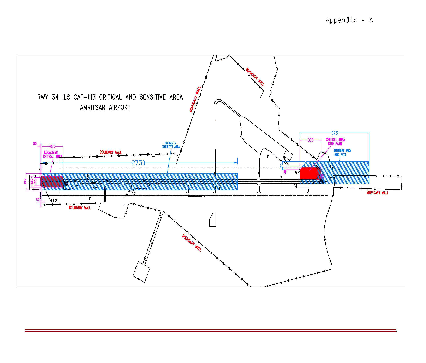
Designation, surface and strength of aprons
|
Refer Aircraft Parking/Docking Chart
|
|
2
|
Designation, width, surface and strength of
taxiways
|
Refer Aircraft Parking/Docking Chart
|
|
3
|
Location and elevation of altimeter checkpoints
|
Location At Holding Point of TWY ‘F’ (Coordinate:314214.19N 0744803.77E) Elevation 753.2 FT
|
|
4
|
Location of VOR checkpoints
|
TWY E: 314232.88N 0744754.99E / ELEV 758FT
TWY F: 314215.14N 0744806.44E / ELEV 756FT
|
|
5
|
Position of INS checkpoints
|
NIL
|
|
6
|
Remarks
|
1. Coordinates of Runway Holding Position:
i. TWY C: 314230.58497N 0744748.41049E/ELEV: 754FT
ii. TWY E (CAT-I): 314232.83063N 0744754.86087E/
ELEV: 755FT
iii. TWY E (CAT-II): 314233.68718N 0744757.32778E/
ELEV: 755FT
iv. TWY F(CAT-I): 314214.21651N 0744803.80603E/
ELEV: 753FT
v. TWY F(CAT-II): 314215.09550N 0744806.30009E/
ELEV: 753FT
vi. TWY P: 314158.31089N 0744815.53098E/ELEV: 752FT
2. Coordinates of RWY & Taxi Intersection:
i. TWY F: 314213.13199N 0744800.58800E/ELEV: 757FT
ii. TWY E: 314231.75901N 0744751.59001E/ELEV: 758FT
3. Elevations in EGM08
|
|
1
|
Use of aircraft stand identification signs, taxiway guidelines and visual docking/parking guidance system at aircraft stands
|
Taxiing guidance signs AVBL. Guidelines at Apron. Nose-in Guidance at aircraft stands, VDGS AVBL for parking bays 3 & 5.
|
|
2
|
Runway and taxiway markings and lights
|
RWY
Markings
Designation, Aiming Point, THR, TDZ, Centreline, Edge, Fillet, Side Strip,
Lighting
Centreline, TDZ, THR, RWY edge, RWY end.
TWY
Markings Centreline, Edge, Fillet
Lighting Edge
|
|
3
|
Stop bars (if any)
|
At TWY E, F and P.
|
|
4
|
Remarks
|
Acft Stand Manoeuvring Guidance Lights:-
Avbl On Bay 3,4,5 And 11.
|
|
In Approach/Take-off/Circling Area and at AD
|
|---|
|
1
|
2
|
3
|
4
|
5
|
6
|
|---|
|
RWY/Area affected
|
Obstacle type
|
Coordinates
|
Elevation
(EGM-08)
|
Marking/LGT
|
Remarks
|
|---|
|
34/TKOF
16/APCH
|
ANTENNA
|
314345.7N
0744719.3E
|
783 FT
|
NIL
|
Antenna on LOC Hut (Hut Top 234.9M)
|
|
34/TKOF
16/APCH
|
OTHER
|
314444.8N
0744626.6E
|
928 FT
|
NIL
|
Cell Phone Tower
|
|
34/TKOF
16/APCH
|
TREE
|
314357.7N
0744714.0E
|
812 FT
|
NIL
|
Group of Trees
|
|
34/TKOF
16/APCH
|
TREE
|
314356.4N
0744715.5E
|
814 FT
|
NIL
|
Group of Trees
|
|
34/TKOF
16/APCH
|
TREE
|
314357.4N
0744706.6E
|
828 FT
|
NIL
|
Group of Trees
|
|
34/TKOF
16/APCH
|
TREE
|
314355.6N
0744703.1E
|
823 FT
|
NIL
|
Tree
|
|
34/TKOF
16/APCH
|
TREE
|
314359.3N
0744710.4E
|
818 FT
|
NIL
|
Tree
|
|
34/TKOF
16/APCH
|
TREE
|
314438.3N
0744636.7E
|
914 FT
|
NIL
|
Group of Trees
|
|
34/TKOF
16/APCH
|
TREE
|
314356.4N
0744704.8E
|
822 FT
|
NIL
|
Group of Trees
|
|
34/APCH
16/TKOF
|
FENCE
|
314142.5N
0744818.2E
|
764 FT
|
NIL
|
Airport Boundary Wall Fencing On Top
|
|
34/APCH
16/TKOF
|
TREE
|
314139.8N
0744820.1E
|
779 FT
|
NIL
|
Group of Trees
|
|
34/APCH
16/TKOF
|
TREE
|
314142.2N
0744820.5E
|
777 FT
|
NIL
|
Group of Trees
|
|
34/APCH
16/TKOF
|
TREE
|
314141.8N
0744819.5E
|
778 FT
|
NIL
|
Group of Trees
|
|
34/APCH
16/TKOF
|
TREE
|
314138.9N
0744812.8E
|
782 FT
|
NIL
|
Group of Trees
|
|
34/APCH
16/TKOF
|
POLE
|
314143.9N
0744819.8E
|
768 FT
|
NIL
|
Perimeter Light Pole
|
|
34/APCH
16/TKOF
|
POLE
|
314144.5N
0744820.1E
|
771 FT
|
NIL
|
Perimeter Light Pole
|
|
34/APCH
16/TKOF
|
TREE
|
314124.1N
0744816.7E
|
816 FT
|
NIL
|
Group of Trees
|
|
34/APCH
16/TKOF
|
BUILDING
|
314143.7N
0744819.7E
|
763 FT
|
NIL
|
Security Hut
|
|
34/APCH
16/TKOF
|
BUILDING
|
314140.3N
0744810.4E
|
762 FT
|
NIL
|
Security Hut
|
|
34/APCH
16/TKOF
|
TREE
|
314121.0N
0744820.1E
|
827 FT
|
NIL
|
Group of Trees
|
|
34/APCH
16/TKOF
|
TREE
|
314131.0N
0744816.8E
|
802 FT
|
NIL
|
Tree
|
|
34/APCH
16/TKOF
|
TREE
|
314127.1N
0744817.9E
|
796 FT
|
NIL
|
Group of Trees
|
|
34/APCH
16/TKOF
|
TREE
|
314117.4N
0744838.1E
|
825 FT
|
NIL
|
Group of Trees
|
|
34/APCH
16/TKOF
|
POLE
|
314143.5N
0744819.0E
|
763 FT
|
NIL
|
Perimeter Light Pole
|
|
34/APCH
16/TKOF
|
TREE
|
314101.8N
0744849.1E
|
860 FT
|
NIL
|
Group of Trees
|
|
34/APCH
16/TKOF
|
OTHER
|
314143.2N
0744817.7E
|
769 FT
|
NIL
|
Mobile Road Traffic (Road Elev. 229.5M+5M Mobile
Traffic)
|
|
34/APCH
16/TKOF
|
TREE
|
314135.0N
0744814.1E
|
793 FT
|
NIL
|
Group of Trees
|
|
34/APCH
16/TKOF
|
FENCE
|
314139.8N
0744810.5E
|
763 FT
|
NIL
|
Airport Boundary Wall Fencing On Top
|
|
34/APCH
16/TKOF
|
FENCE
|
314143.8N
0744820.9E
|
765 FT
|
NIL
|
Airport Boundary Wall Fencing On Top
|
|
34/APCH
16/TKOF
|
OTHER
|
314140.7N
0744810.2E
|
771 FT
|
NIL
|
Mobile Road Traffic
(Road Elev.
230.1M+5M Mobile
Traffic)
|
|
34/APCH
16/TKOF
|
OTHER
|
314145.8N
0744819.3E
|
770 FT
|
NIL
|
Mobile Road Traffic
(Road Elev.
229.6M+5M Mobile
Traffic)
|
|
In circling area and at AD
|
BUILDING
|
314334.9N
0744726.9E
|
767 FT
|
NIL
|
Bird Chaser Hut
|
|
In circling area and at AD
|
ANTENNA
|
314328.1N
0744729.1E
|
769 FT
|
NIL
|
MET VRF Antenna
|
|
In circling area and at AD
|
ANTENNA
|
314329.0N
0744728.7E
|
769 FT
|
NIL
|
MET VRF Antenna
|
|
In circling area and at AD
|
ANTENNA
|
314157.3N
0744812.7E
|
761 FT
|
NIL
|
MET VRF Antenna
|
|
In circling area and at AD
|
BUILDING
|
314158.1N
0744812.9E
|
761 FT
|
NIL
|
Bird Chaser Hut
|
|
In circling area and at AD
|
ANTENNA
|
314159.5N
0744811.5E
|
763 FT
|
NIL
|
MET VRF Antenna
|
|
In circling area and at AD
|
ANTENNA
|
314158.6N
0744811.9E
|
763 FT
|
NIL
|
MET VRF Antenna
|
|
In circling area and at AD
|
ANTENNA
|
314159.4N
0744812.1E
|
771 FT
|
NIL
|
Antenna
|
|
In circling area and at AD
|
NAVAID
|
314154.7N
0744814.7E
|
772 FT
|
NIL
|
G.P. Monitor Antenna
|
|
In circling area and at AD
|
NAVAID
|
314157.2N
0744813.5E
|
801 FT
|
NIL
|
G.P. Antenna
|
|
In circling area and at AD
|
NAVAID
|
314157.2N
0744813.3E
|
772 FT
|
NIL
|
G.P./DME Antenna
|
|
In circling area and at AD
|
BUILDING
|
314157.3N
0744813.3E
|
765 FT
|
NIL
|
GP Hut
|
|
In circling area and at AD
|
BUILDING
|
314241.4N
0744752.5E
|
766 FT
|
NIL
|
Structure
|
|
In circling area and at AD
|
ANTENNA
|
314238.0N
0744751.8E
|
764 FT
|
NIL
|
MET VRF Antenna
|
|
In circling area and at AD
|
ANTENNA
|
314239.5N
0744751.3E
|
766 FT
|
NIL
|
MET VRF Antenna
|
|
In circling area and at AD
|
ANTENNA
|
314240.4N
0744750.9E
|
766 FT
|
NIL
|
MET VRF Antenna
|
|
In circling area and at AD
|
BUILDING
|
314308.7N
0744740.9E
|
789 FT
|
NIL
|
Watch Tower
|
|
In circling area and at AD
|
TREE
|
314250.5N
0744728.7E
|
856 FT
|
NIL
|
Tree
|
|
In circling area and at AD
|
ANTENNA
|
314227.4N
0744746.3E
|
790 FT
|
NIL
|
Antenna on Building
|
|
In circling area and at AD
|
OTHER
|
314226.1N
0744747.2E
|
777 FT
|
NIL
|
Wind Direction Indicator
|
|
In circling area and at AD
|
OTHER
|
314337.2N
0744720.0E
|
762 FT
|
NIL
|
APP Light
|
|
In circling area and at AD
|
TREE
|
314336.1N
0744711.3E
|
803 FT
|
NIL
|
Tree
|
|
In circling area and at AD
|
TREE
|
314139.3N
0744827.2E
|
811 FT
|
NIL
|
Tree
|
|
In circling area and at AD
|
POLE
|
314146.8N
0744821.1E
|
784 FT
|
NIL
|
Perimeter Light Pole
|
|
In circling area and at AD
|
POLE
|
314146.5N
0744820.0E
|
784 FT
|
NIL
|
Perimeter Light Pole
|
|
In circling area and at AD
|
POLE
|
314145.0N
0744820.9E
|
784 FT
|
NIL
|
Perimeter Light Pole
|
|
In circling area and at AD
|
POLE
|
314145.3N
0744821.9E
|
784 FT
|
NIL
|
Perimeter Light Pole
|
|
In circling area and at AD
|
POLE
|
314146.3N
0744819.2E
|
765 FT
|
NIL
|
Perimeter Light Pole
|
|
In circling area and at AD
|
TREE
|
314240.6N
0744756.6E
|
818 FT
|
NIL
|
Tree
|
|
In circling area and at AD
|
ANTENNA
|
314241.9N
0744752.4E
|
763 FT
|
NIL
|
MET VRF Antenna
|
|
In circling area and at AD
|
BUILDING
|
314250.2N
0744750.0E
|
790 FT
|
NIL
|
Watch Tower
|
|
In circling area and at AD
|
TREE
|
314252.4N
0744748.3E
|
778 FT
|
NIL
|
Tree
|
|
In circling area and at AD
|
TREE
|
314344.4N
0744726.7E
|
823 FT
|
NIL
|
Tree
|
|
In circling area and at AD
|
OTHER
|
314228.7N
0744749.5E
|
785 FT
|
NIL
|
Wind Direction Indicator
|
|
In circling area and at AD
|
OTHER
|
314340.7N
0744709.8E
|
792 FT
|
NIL
|
Lightning Rod (L)
|
|
In circling area and at AD
|
SIGN
|
314150.8N
0744812.9E
|
757 FT
|
NIL
|
Sign Board
|
|
In circling area and at AD
|
ANTENNA
|
314159.5N
0744811.6E
|
761 FT
|
NIL
|
MET VRF Antenna
|
|
In circling area and at AD
|
OTHER
|
314329.1N
0744728.6E
|
766 FT
|
NIL
|
MET VRF Box
|
|
In circling area and at AD
|
OTHER
|
314324.6N
0744728.7E
|
761 FT
|
NIL
|
PAPI
|
|
In circling area and at AD
|
OTHER
|
314324.3N
0744727.8E
|
761 FT
|
NIL
|
PAPI
|
|
In circling area and at AD
|
OTHER
|
314241.0N
0744749.4E
|
758 FT
|
NIL
|
Elect Circuit Box
|
|
In circling area and at AD
|
SIGN
|
314235.0N
0744751.6E
|
758 FT
|
NIL
|
Sign Board
|
|
In circling area and at AD
|
SIGN
|
314229.4N
0744754.3E
|
759 FT
|
NIL
|
Sign Board
|
|
In circling area and at AD
|
SIGN
|
314216.4N
0744800.5E
|
759 FT
|
NIL
|
Sign Board
|
|
In circling area and at AD
|
SIGN
|
314210.7N
0744803.3E
|
758 FT
|
NIL
|
Sign Board
|
|
In circling area and at AD
|
OTHER
|
314204.8N
0744806.4E
|
759 FT
|
NIL
|
Elect Circuit Box
|
|
In circling area and at AD
|
OTHER
|
314204.4N
0744806.5E
|
759 FT
|
NIL
|
Elect Circuit Box
|
|
In circling area and at AD
|
OTHER
|
314156.4N
0744806.3E
|
756 FT
|
NIL
|
PAPI
|
|
In circling area and at AD
|
OTHER
|
314156.5N
0744806.6E
|
756 FT
|
NIL
|
PAPI
|
|
In circling area and at AD
|
OTHER
|
314156.7N
0744807.0E
|
756 FT
|
NIL
|
PAPI
|
|
In circling area and at AD
|
SIGN
|
314203.4N
0744803.5E
|
760 FT
|
NIL
|
Sign Board
|
|
In circling area and at AD
|
SIGN
|
314213.2N
0744758.9E
|
759 FT
|
NIL
|
Sign Board
|
|
In circling area and at AD
|
SIGN
|
314230.1N
0744750.7E
|
759 FT
|
NIL
|
Sign Board
|
|
In circling area and at AD
|
SIGN
|
314236.1N
0744747.7E
|
759 FT
|
NIL
|
Sign Board
|
|
In circling area and at AD
|
OTHER
|
314240.0N
0744745.9E
|
758 FT
|
NIL
|
Elect Circuit Box
|
|
In circling area and at AD
|
OTHER
|
314240.1N
0744745.9E
|
758 FT
|
NIL
|
Elect Circuit Box
|
|
In circling area and at AD
|
SIGN
|
314243.3N
0744744.4E
|
759 FT
|
NIL
|
Sign Board
|
|
In circling area and at AD
|
SIGN
|
314249.6N
0744741.1E
|
760 FT
|
NIL
|
Sign Board
|
|
In circling area and at AD
|
SIGN
|
314317.0N
0744727.8E
|
761 FT
|
NIL
|
Sign Board
|
|
1
|
Name of the associated meteorological office
|
Amritsar
|
|
2
|
Hours of service and, where applicable, the designation of the responsible meteorological office outside these hours
|
H24
|
|
3
|
Office responsible for preparation of TAFs and periods of validity and interval of issuance of the forecasts
|
Delhi
9Hrs
|
|
4
|
Availability of the trend forecast for the aerodrome and interval of issuance
|
AVBL, issued every half an hour BTN 0800 IST and 2000 IST
|
|
5
|
Information on how briefing and/or consultation is provided
|
AVBL with prior coordination
|
|
6
|
Types of flight documentation supplied and language(s) used in flight documentation
|
Tabular Form (English)
|
|
7
|
Charts and other information displayed or available for briefing or consultation
|
NIL
|
|
8
|
Supplementary equipment available for providing information on meteorological conditions, e.g. weather radar and receiver for satellite images;
|
RVR Transmissometer instrument AVBL at TDZ, MID and end of RWY16/34.
|
|
9
|
The air traffic services unit(s) provided with meteorological information
|
VIAR Amritsar TWR/APP
|
|
10
|
Additional information, e.g. concerning any limitation of service.
|
Class III Met Office. RVR system 'DRISHTI' commissioned at RWY34 end. The system provides RVR data BTN 50M to 2000M. Instrument RVR observation AVBL in ATC tower.
|
Facility
|
Unserviceability
|
Restrictions
|
Arrivals
|
Departures
|
ILS Localizer
|
One transmitter
unserviceable
|
Suspend CAT II /
CATIIIA / CATIIIB
operations.
|
No restriction
|
ILS Glide
Path
|
One transmitter
unserviceable
|
Suspend CAT II /
CATIIIA / CATIIIB
operations.
|
No restriction
|
ILS DME
|
One transmitter
unserviceable
|
Suspend CAT II /
CATIIIA / CATIIIB
operations.
|
No restriction
|
RVR System
|
TDZ RVR
|
Suspend CAT II /
CATIIIA / CATIIIB
operations.
|
Suspend
Departures below
800 M Visibility.
|
MID RVR
|
Suspend CATIIIA / CATIIIB
operations.
|
Suspend
Departures below
400 M RVR.
|
END RVR
|
Suspend CATIIIA / CATIIIB
operations.
|
Suspend
Departures below
400 M RVR.
|
MID and END RVR
|
Suspend CAT II /
CATIIIA / CATIIIB
operations.
|
Suspend
Departures below
400 M RVR.
|
Stand By
Power Supply
lights
|
Generator
unserviceable
|
Suspend CAT II /
CATIIIA / CATIIIB
operations
|
Suspend
Departures below
400 M RVR.
|
Stop Bars
|
|
Suspend CATIIIA / CATIIIB
operations
|
Suspend
Departures below
400 M RVR.
|
Approach
Lights
|
The inner 450
meters- more than
5 % of all lights
|
Suspend CAT II /
CATIIIA / CATIIIB
operations
|
No restriction
|
Beyond 450
meters more than
15% of all lights
|
Runway Edge
lights
|
More than 5% of
all Lights
|
Suspend CAT II /
CATIIIA / CATIIIB
operations
|
Suspend
Departures below
800 M Visibility
|
Two adjacent
lamps
|
Runway
Center-line
|
More than 5% of
all Lights
|
Suspend CAT II /
CATIIIA / CATIIIB
operations
|
Suspend
Departures below
400 M RVR
|
Two adjacent
lamps
|
Touchdown
Zone lights
|
More than 10%
of all Lights
|
Suspend CAT II /
CATIIIA / CATIIIB
operations
|
No restriction
|
Two lamp in
Barrette
|
Threshold
lights
|
More than 5% of
all Lights
|
Suspend CAT II /
CATIIIA / CATIIIB
operations
|
No restriction
|
Two adjacent
lamps
|
Runway End
lights
|
More than 25% of
all Lights
|
Suspend CAT II /
CATIIIA / CATIIIB
operations
|
Suspend
Departures below
800 M/550M Visibility/RVR
|
Two adjacent
lamps
|
Taxiway
Centre-line
lights
|
Not applicable to
CATII operation
|
Close affected
taxiways, use alternate
taxi route.
|
Close affected taxiways, use
alternate taxi route.
Alternate stop departures below 400 M RVR
|
Two adjacent
lamps
|