1. SATELLITE-BASED AUGMENTATION SYSTEMS (SBAS)
1.1 A satellite-based augmentation system (SBAS) augments core satellite constellations by providing integrity and correction information via geostationary satellites. The system comprises a network of ground reference stations that observe satellite signals and master stations that process observed data and generate SBAS messages for uplink to the geostationary satellites, which broadcast the SBAS messages to the users.
1.2 Key to providing accurate and high integrity approach capability with SBAS is correction for the signal delay caused by the ionosphere. This requires a relatively dense network of reference stations to measure ionospheric characteristics and provide information to the SBAS Master Station
2 GPS AIDED GEO AUGMENTED NAVIGATION (GAGAN) SYSTEM
2.1 Airports Authority of India (AAI) in collaboration with Indian Space Research Organisation (ISRO) has developed the Indian SBAS called GPS Aided GEO Augmented Navigation (GAGAN) System to improve the accuracy, integrity and
availability of GPS signals. GAGAN allows use of GPS as the aviation navigation system, from take-off through near Category I precision approach. GAGAN is a critical component of the AAI's strategic plan to establish a seamless satellite navigation system for civil aviation for enhancing capacity and safety.
2.2 The International Civil Aviation Organization (ICAO) has defined Standards and Recommended Practices (SARPs) for satellite-based augmentation systems (SBAS). SBAS, such as the Wide Area Augmentation System of USA (WAAS), the European Geostationary Navigation Overlay System (EGNOS) and Multifunctional Transport Satellite (MTSAT) Satellite-based Augmentation System (MSAS) of Japan are operational and are providing various levels of SBAS Services. These systems are interoperable with each other. The Indian SBAS (GAGAN) is compliant to all the provisions of ICAO SARPS and interoperable with other SBAS. The interoperability among these systems create a worldwide seamless navigation capability, similar to GPS but with greater accuracy, availability and integrity.
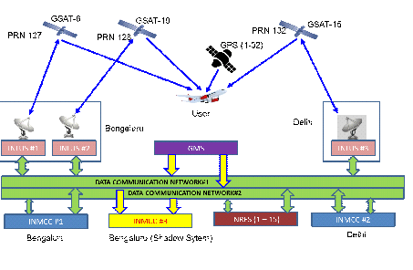
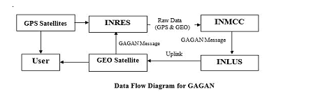
2.3 Unlike conventional ground-based navigation aids, with line-of-sight operation as a limiting factor, GAGAN covers a larger service area. Signals from the GPS satellites are monitored by widely spread network of Indian Reference Stations (INRES) to determine satellite clock and ephemeris corrections and to model the propagation effects of the ionosphere. Each station in the network relays the observed data to Indian Master Control Centres (INMCC) where the correction information and integrity bounds are computed. A correction message is prepared and uplinked to a geostationary satellite (GEO) via Indian Land Uplink Stations (INLUS). The message is then broadcasted on the same frequency as GPS (L1, 1575.42 MHz) to SBAS receivers within the coverage area of the GAGAN GEO.
2.4 The integrity of GPS is improved through real-time monitoring, and the accuracy is improved by providing differential corrections to reduce errors. The performance improvement is sufficient to enable approach procedures with vertical guidance (APV).
2.5 GNSS navigation, including GPS and GAGAN, is referenced to the WGS-84 coordinate system. It would only be used where the Aeronautical Information Publications (including electronic data and aeronautical charts) conform to WGS-84
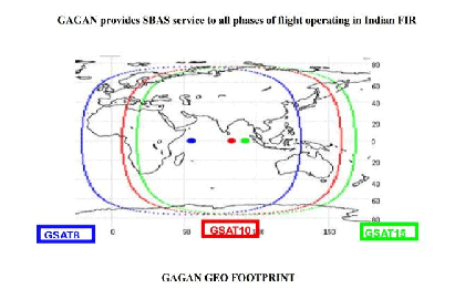
2.6 GAGAN system is certified by Director General of Civil Aviation, India and presently GAGAN Signal-in-Space is available over Indian Airspace through GSAT-8 (PRN127), GSAT-10 (PRN-128) and GSAT-15 (PRN-132
3 SBAS (GAGAN) STANDARD CONDITIONS
All classes of SBAS avionics may be used to fly existing GNSS RNAV departure procedures. Display scaling and mode transitions are equivalent to Basic GNSS. SBAS meets or exceeds Basic GNSS accuracy, integrity, availability and continuity requirements for Basic GNSS departure
The entire departure procedure shall be selected from on-board database. Manual entry of the departure procedure is not authorized. When integrity requirements cannot be met to support the SBAS departure operation, the SBAS receiver will annunciate the procedure is not available.
Performance requirements for SBAS in the arrival phase are the same as for Basic GNSS.
4. INSTRUMENT APPROACH CAPABILITIES
4.1 A new class of approach procedures which provides vertical guidance, but which does not meet the DGCA CAR,
Section-9 Air Space and Air Traffic Management, Series-D Part-II, Issue-II requirements for precision approaches has been developed to support satellite navigation use for aviation applications worldwide.These procedures called Approach with
Vertical Guidance (APV) include approaches such as the LNAV/VNAV procedures which are flown with Barometric Vertical Navigation (Baro-VNAV). These approaches provide vertical guidance, but do not meet the more stringent standards of a precision approach. Certified SBAS receivers can able to fly these LNAV/VNAV procedures using a GAGAN electronic glide path, which eliminates some errors that can be introduced by using Barometric altimetry, such as temperature.
4.2 SBAS (GAGAN) based LPV/LP approach procedures, in addition to LNAV, LNAV/VNAV are being implemented to take advantage of high accuracy guidance and increased integrity provided by GAGAN. At present, GAGAN allows APV-1/Cat 1 type ‘A’ approach upto a decision height of 250 ft with a visibility minima close to ILS approach.
4.3 When equipped with appropriate avionics, GAGAN will provide a level of service that supports all phases of flight, including RNAV (GNSS) approaches to LNAV, LNAV/VNAV and LPV lines of minima within the defined GAGAN service volume. Some locations close to the edge of the coverage may have a lower availability of approaches that provide vertical guidance.
SBAS avionics accurately calculate position, and ensure integrity in the calculated position for a given approach operation type.
The necessary level of integrity for each of these approach types is established by specific horizontal and vertical alert limits called HAL and VAL. These limits are analogous to the monitoring limits for ILS. These alert limits form the region of
maximum error that shall be satisfied to meet the integrity requirements for a given approach type.
4.6 SBAS avionics ensure integrity in the calculated position for a given approach type, by continuously calculating the horizontal and vertical protection level estimates (HPL and VPL) and comparing the calculated values with HAL and VAL respectively. When either HPL or VPL exceeds the specific alert limits, HAL or VAL, for a specific type of approach operation, the pilot is alerted to suspend the current operation. The pilot only receives the alert and is not required to monitor VPL or HPL.
5.1 These procedures are designed for following types of operations:
a) 2 D approach operation type A: LP minima
b) 3 D approach operation type A: LPV minima (APV)
c) 3 D approach operation type A or B: LPV minima (Cat 1)
Note: Published temperature restrictions for barometric VNAV procedures do not apply to SBAS approach operations.
5.2 SBAS equipment may be used to operate on procedures based on baro-VNAV criteria. In such cases published temperatures restrictions for barometric VNAV procedures do not apply.
6 GENERAL REQUIREMENTS FOR SBAS (GAGAN) OPERATIONS
6.1.1. SBAS avionics equipment classification and capabilities
There are four separate SBAS avionics equipment classes. The different equipment classes provide for different performance capabilities. The minimum performance capability exists with Class 1 equipment. This equipment supports oceanic and domestic en-route, terminal and LNAV approach operations. Class 2 SBAS equipment supports Class 1 capabilities and LNAV/VNAV approach operations. Class 3 and 4 equipment support Class 2 SBAS equipment capabilities plus LP & LPV approach operations. Class 4 equipment supports only the final approach segment operation. This class of equipment is intended to serve as an ILS alternative that supports LP and LPV operations with degradation (fail-down) from LPV to lateral only (LNAV).
6.1.2. The avionics shall be certified in accordance with Technical Standard Order (TSO) TSO-C145, Airborne Navigation Sensors Using the (GPS) Augmented by Satellite Based Augmentation System; or TSO-146, Stand-Alone Airborne Navigation Equipment Using the Global Positioning System (GPS) Augmented by the Satellite Based Augmentation System, and installed in accordance with FAA Advisory Circular (AC) 20-130A, Airworthiness Approval of Navigation or Flight Management Systems Integrating Multiple Navigation Sensors, or AC 20-138 Airworthiness Approval of Global Positioning System (GPS) Navigation Equipment for Use as a VFR and IFR Navigation System.
NOTE: The terms APV-I refer to a performance level of GNSS approach and landing operations with vertical guidance, and this term is not intended to be used and these terms are not necessarily intended to be used operationally. For charting of the minima lines, the term LPV is applied to align with SBAS avionics annunciation requirements.
6.1.3. SBAS Avionics Annunciation Requirements
6.1.3.1.The avionics are required to annunciate the most accurate level of service supported by the combination of the SBAS signal, the receiver, and the selected approach, using the naming conventions on the minima lines of the selected approach procedure. This annunciation is the function of:
a) Avionics capability associated with the SBAS equipment capability;
b) SBAS signal-in-space performance accomplished through the comparison of VPL and HPL with the procedure required VAL and HAL; and
c) Published procedure availability that is identified in the database.
6.2. GPS/GAGAN operation must be conducted in accordance with the approved aircraft flight manual (AFM) and flight manual supplements. Flight manual supplements shall state the level of approach procedure that the receiver supports. IFR approved SBAS receivers support all GPS only operations as long as lateral capability at the appropriate level is functional. GAGAN monitors both GPS and GAGAN satellites and provides integrity alerting.
6.3. GPS/GAGAN equipment is inherently capable of supporting oceanic and remote operations if the operator obtains a fault detection and exclusion (FDE) prediction program.
6.4. Air carrier and commercial operators must meet the appropriate provisions of their approved operations specifications.
6.5. Prior to GNSS/GAGAN IFR operation, the pilot must review appropriate Notices to Airmen (NOTAMs) and aeronautical information. AAI will provide NOTAMs to advise pilots of the status of the GAGAN and level of service available.
a) Area-wide GAGAN UNAVAILABLE NOTAMs indicate loss or malfunction of the GAGAN system. In flight, pilots who request a RNAV (GNSS) approach will be advised by Air Traffic Control, of GAGAN UNAVAILABLE NOTAMs
if not contained in the ATIS broadcast. Since the GNSS/SBAS receiver will revert to a GNSS receiver in this instance, GNSS-based approaches may still be conducted if the receiver indicates that service is available.
NOTE: Area wide GAGAN UNAVAILABLE NOTAMs apply to all airports in the GAGAN UNAVAILABLE area
designated in the NOTAM, including approaches.
6.6. SBAS Receivers have been developed to be used within SBAS GEO coverage (GAGAN or other interoperable system) without the need for other radio navigation equipment appropriate to the route of flight to be flown. Outside the GAGAN coverage or in the event of a GAGAN failure, GNSS/GAGAN equipment reverts to GNSS-only operation and satisfies the requirements for basic GPS equipment.
7 FLYING PROCEDURES WITH GAGAN
7.1. On-board SBAS receivers support all basic GNSS approach functions and provide additional capabilities. One of the major improvements is the ability to generate glide path guidance, independent of ground equipment or barometric aiding. This eliminates several problems such as hot and cold temperature effects, incorrect altimeter setting or lack of a local altimeter source. It also allows approach procedures to be built without the cost of installing ground stations at each airport or runway. Some approach certified receivers may only generate a glide path with performance similar to Baro-VNAV and
are only approved to fly the LNAV/VNAV line of minima on the RNAV (GNSS) approach charts. Receivers with additional capability (including SBAS, faster update rates and smaller integrity limits) are approved to fly the LPV line of minima. The lateral integrity changes dramatically from the 0.3 NM (556 meters) limit for GNSS LNAV and LNAV/VNAV approach mode, to 40 meters for LPV. It also provides vertical integrity monitoring, which bounds the vertical error to 50 meters for LNAV/VNAV and LPVs with minima of 250 FT or above.
7.2. APPROACH PROCEDURE
7.2.1. When an approach procedure is selected and active, the receiver will notify the pilot of the most accurate level of service supported by the combination of the GAGAN signal, the receiver, and the selected approach, using the naming conventions on the minima lines of the selected approach procedure. For example, if an approach is published with LPV minima and the receiver is only certified for LNAV/VNAV, the equipment would indicate “LNAV/VNAV available,” even though the GAGAN signal would support LPV. If flying an existing LNAV/VNAV procedure with no LPV minima, the receiver will notify the pilot “LNAV/VNAV available,” even if the receiver is certified for LPV and the signal supports LPV. If the signal does not support vertical guidance on procedures with LPV and/or LNAV/VNAV minima, the receiver annunciation will read “LNAV available.” On lateral only procedures with LNAV minima, the receiver will indicate “LNAV available”. Once the level of service notification has been given, the receiver will operate in this mode for the duration of the approach procedure, unless that level of service becomes unavailable. The receiver cannot change back to a more accurate level of service until the next time an approach is activated.
Note: Mode selections may be different in some receivers
7.2.2. Another additional feature of SBAS receivers is the ability to exclude a bad GPS signal and continue operating normally. This is normally accomplished by the GAGAN correction information. Outside GAGAN coverage or when GAGAN is not available, it is accomplished through a receiver algorithm called FDE. In most cases this operation will be invisible to the pilot since the receiver will continue to operate with other available satellites after excluding the "bad" signal. This capability increases the reliability of navigation.
Note: FDE is also installed in many Non- SBAS receivers.
7.3. MISSED APPROACH
7.3.1. General:
SBAS provides guidance in the missed approach segment. Activation of missed approach guidance generally occurs during
a high pilot workload period. SBAS avionics standards, described in RTCA DO- 229D have significantly improved the
pilot/avionics interface for activating missed approach guidance, when compared to basic GNSS avionics standards. SBAS avionics minimum operating performance requirements specify much more standardization in the pilot/avionics interface than was present in the specifications for basic GNSS avionics. Because of this standardization, and other SBAS avionics missed approach requirements, pilots will be able to more efficiently and easily initiate the sequencing to the missed approach segment.
7.3.2. With SBAS avionics, missed approaches may be initiated under four different conditions. The conditions are:
a) the pilot initiates the missed approach sequence prior to arriving at the landing threshold point/fictitious threshold point (LTP/FTP);
b) the pilot initiates the missed approach sequence after the LTP/FTP but prior to the departure end of runway (DER);
c) the pilot does not initiate missed approach sequencing prior to reaching the DER. In this case, the avionics will automatically initiate the missed approach; and
d) the pilot cancels the approach mode prior to the LTP/FTP.
7.4. Publication and minima line description for APV:
The charted minima lines associated with SBAS APV-I performance levels are labelled “LPV” (localizer performance with vertical guidance). This labelling is consistent with existing SBAS avionics standard annunciations and indicates that the lateral performance is equivalent to an ILS localizer lateral performance.
NOTE: The term APV-I refers to a performance level of GNSS approach and landing operations with vertical guidance, and this term is not intended to be used and these terms are not necessarily intended to be used operationally. For charting of the minima lines, the term LPV is applied to align with SBAS avionics annunciation requirements.
8 PROMULGATION
8.1. The instrument approach chart for an SBAS Approach Procedure shall be identified by the title RNAV (GNSS) or RNP Rwy ‘XX’
8.2. Minima Box:
All APV 1 and Cat 1 SBAS OCA/Hs are promulgated as LPV lines of minima. All NPA SBAS OCA/Hs shall be promulgated on LP lines of minima.
8.3. SBAS FAS DB information to be promulgated:
The following information shall be promulgated for SBAS APV procedures: -
(a) Channel number
(b) Reference path Identifier (RPI)
(c) SBAS service provider
(d) FPAP and LTP orthometric height
8.4. Non-applicability of the charted temperature restriction for SBAS LNAV/VNAV procedures:
Charted barometric VNAV temperature restrictions do not apply when vertical guidance is provided by SBAS.
8.5. Promulgation of information concerning SBAS NOTAM service.
The information that has to be promulgated to the pilot is the identification of the level
of SBAS NOTAM service that is provided in specific locations. AAI is responsible to
identify the level of SBAS NOTAM service that is available.
9 OPERATIONAL BENEFITS OF GAGAN
9.1 SBAS avionics enable aircraft navigation during all phases of flight, from take-off through vertically guided approaches and guided missed approaches. SBAS avionics with an appropriate airworthiness approval can enable aircraft to fly to the LPV, LNAV/VNAV, and LNAV lines of minima on RNAV (GNSS) approaches. One of the major improvements GAGAN provides is the ability to generate vertical guidance independent of ground equipment. Temperature and pressure extremes do not affect GAGAN vertical guidance--unlike where baro-VNAV is used to fly to LNAV/VNAV line of minima. However, like most other navigation services, GAGAN too has service volume limits. Some airports on the fringe of GAGAN coverage may experience reduced availability of GAGAN vertical guidance. When a pilot selects an approach procedure, SBAS avionics display the best level of service supported by the combination of the GAGAN signal-in-space, the aircraft avionics, and the selected RNAV (GPS) instrument approach.
Note: RNAV (GNSS) approach operations to LNAV, LNAV/VNAV, and LPV and LP lines of minima are classified as an RNP approach (RNP APCH) in the ICAO PBN Manual.
Major benefits of GAGAN for civil aviation include:
• Flight Management System (FMS) based on GAGAN saves operators’ time and money by managing climb, descent, and engine performance profiles.
• The FMS based on GAGAN improves the efficiency and flexibility by increasing the use of Trajectory Based Operations (TBO)
• Improve airport and airspace access in all weather conditions, and the ability to meet the environmental and obstacle clearance constraints.
• Enhance reliability and reduce delays by defining more precise terminal area procedures that feature parallel routes and environmentally optimized airspace corridors.
• Increase safety by using a three-dimensional approach operation with course guidance to the runway, which will reduce the risk of Controlled Flight Into Terrain (CFIT).
• GAGAN also offers high position accuracies over a wide geographical area. These positions accuracies are simultaneously available to all airports and airfields.
• Provide near precision approach, at airports where it is impossible or uneconomical to install terrestrial Navigational aids because of terrain.
• Enhance Air-to-Air Surveillance (ADS-B)
• Direct routes - Increased fuel savings
• Availability of Minimum Safe Altitude Warning (MSAW) facility
From the perspective of the aircrew, a GNSS anomaly occurs when navigation guidance is lost or when it is not possible to trust GNSS guidance. In this respect, an anomaly is similar to a service outage. An anomaly may be associated with a receiver or antenna malfunction, insufficient satellites in view, poor satellite geometry or masking of signals by the airframe. The perceived anomaly may also be due to signal interference, but such a determination requires detailed analysis based on all available information.
a) reporting the situation to ATC as soon as practicable and requesting special handling as required;
b) forwarding the aircraft call sign, location, altitude and time of occurrence to ATC; and
c) forwarding information to the designated authority as soon as possible, including a description of the event (e.g. how the
avionics failed/reacted during the anomaly).
The form to be used by pilots to report any anomaly related to performance of GPS/GAGAN is given below for ready reference. The list of anomaly given in below form is not exhaustive. These anomalies may be annunciated on cockpit displays, include those listed below, several of which may occur simultaneously: Please put (✓) mark in the box/boxes, as applicable.
[ ] Large position errors (details):
[ ] Loss of integrity (RAIM warning/alert)
[ ] Loss of satellites in view (details):
[ ] Lateral indicated performance level changed from ___ to ___
[ ] Vertical indicated performance level changed from ___ to ___
[ ] Indicated dilution of precision changed from ___ to ___
[ ] information on PRN of affected satellites (if applicable)
[ ] Low signal-to-noise (density) ratio
[ ] GPS 1 Invalid/GPS 2 Invalid
[ ] Switching to an alternate navigation mode (such as IRS updating or
[ ]Observation of a “map shift” on navigation display
[ ] Enhanced ground proximity warning alerts
[ ] Sustained loss of automatic dependent surveillance (ADS) reporting
Annexure 1
DEFINITIONS
a) Area Navigation (RNAV): A method of navigation which permits aircraft operation on any desired flight path within the coverage of ground or space-based Navigational Aids (NAVAID) or within the limits of the capability of self-contained aids, or a combination of these.
b) RNAV System: A navigation system which permits aircraft operation on any desired flight path within the coverage of ground or space-based NAVAIDs or within the limits of the capability of self-contained aids, or a combination of these. An RNAV system may be included as part of a flight management system (FMS).
c) Barometric Aiding (Baro-Aiding): A method of augmenting the GPS integrity solution in receiver autonomous integrity monitoring (RAIM) by using a barometric altitude input source. Baro-aiding requires four satellites and a barometric altimeter to detect an integrity anomaly (the current altimeter setting may need to be entered into the receiver as described in the operating manual). Baro-aiding satisfies the RAIM requirement in lieu of a fifth satellite.
d) Barometric Vertical Navigation (Baro-VNAV): An RNAV system function which uses barometric altitude information from the aircraft’s altimeter to compute and present a vertical guidance path to the pilot. The specified vertical path is computed as a geometric path, typically computed between two waypoints or an angle based computation from a single way point.
e) Decision Altitude (DA): In an approach with approved vertical guidance, DA is a specified altitude expressed in feet above mean sea level (MSL) at which a missed approach must be initiated if the required visual references to continue the approach have not been established.
f) Fault Detection and Exclusion (FDE): A receiver autonomous integrity monitoring (RAIM) algorithm that can automatically detect and exclude a faulty satellite from the position solution when measurements from six or more satellites are available. SBAS equipment uses FDE for integrity whenever a SBAS signal is not available to permit continued operation from en route through approach operations.
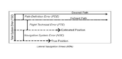
g) Flight Technical Error (FTE): FTE is the accuracy with which an aircraft is controlled, as measured by the indicated aircraft position with respect to the indicated command or desired position. It does not account for procedural blunder errors.
h) Global Navigation Satellite System (GNSS): GNSS refers collectively to the worldwide positioning, navigation, and timing determination capability available from one or more satellite constellations in conjunction with a network of ground stations.
i) Global Positioning System (GPS): GPS refers to the worldwide positioning, navigation and timing determination capability available from the U.S. satellite constellation. The service provided by GPS for civil use is defined in the GPS Standard Positioning System Performance Standard. The GPS coordinate system is the Cartesian earth-centered earth-fixed coordinates as specified in the World Geodetic System 1984 (WGS-84).
j) Integrity: Integrity is a measure of the trust that can be placed in the correctness of the information supplied by the total system. Integrity includes the ability of a system to provide timely and valid warnings to the user (alerts).
k) Lateral Navigation (LNAV): An RNAV function that computes, displays, and provides horizontal approach navigation without approved vertical guidance.
l) Lateral Navigation/Vertical Navigation (LNAV/VNAV): An RNAV function that computes, displays, and provides both horizontal and approved vertical approach navigation. Both SBAS vertical guidance and baro-VNAV support approaches to
m) Localizer Performance with Vertical Guidance (LPV) : An RNAV function requiring SBAS, using a final approach segment (FAS) data block, which computes, displays and provides both horizontal and approved vertical approach navigation to minimums as low as 200ft ceiling and ½ mile visibility.
n) Minimum Descent Altitude (MDA): In an approach without approved vertical guidance, MDA is a specified minimum altitude expressed in feet above MSL, below which descent must not be made
o) Receiver Autonomous Integrity Monitoring (RAIM) : An algorithm that verifies the integrity of the position output using measurements from five or more GPS satellites, or four or more GPS satellites and baro-aiding.
p) Required Navigation Performance (RNP): RNP is a statement of the 95 percent navigation accuracy performance that meets a specified value for a particular phase of flight or flight segment and incorporates associated on-board performance monitoring and alerting features to notify the pilot when the RNP for a particular phase or segment of a flight is not being met.
q) Required Navigation Performance Approach (RNP APCH): RNP APCH is a navigation specification based on area navigation that includes the requirement for onboard performance monitoring and alerting features to notify the pilot when the RNP for the approach phase of flight is not being met. (LPV and LP operations are found in the RNP APCH navigation specifications of the International Civil Aviation Organization (ICAO) Performance-based Navigation Manual.)
r) Satellite-Based Augmentation System (SBAS): SBAS is a wide area coverage augmentation system. The user receives GPS constellation augmentation information from a geostationary satellite-based transmitter. SBAS complements the core GPS satellite constellation by increasing navigation accuracy, integrity, continuity, and availability provided within a service area. The Indian SBAS is GAGAN.