ENR 1.9 AIR TRAFFIC FLOW MANAGEMENT AND AIRSPACE MANAGEMENT

1.

Introduction

1.1

Air Traffic Flow Management (ATFM) is a service established in order to contribute to a safe, orderly and expeditious air traffic movement, ensuring that air traffic volume is compatible with capacities declared by the ATS authority.

1.2

ATFM is primarily meant to address the balancing of demand against the capacity to achieve optimum utilization of the major resources viz., Airport, Airspace and aircraft at every Indian airport where there is a capacity constraint.

1.3

The function of balancing demand and capacity consists of evaluating the air traffic flows and taking timely and appropriate measures for reducing the effects of limitations of the ATM system to a minimum. A process of collaboration is adopted for efficient management of system-wide air traffic flows through timely information sharing on air traffic, the weather conditions and other resources available among all stakeholders.

1.4

By creating optimum balance between demand and capacity, the ATFM system enables airspace users to participate in the ATM system in an optimal manner, mitigating at the same time constraints related to the airspace and aerodrome capacity. The collaborative decision-making process ensures greater equitable access and a more efficient use of the airport and airspace resources.

1.5

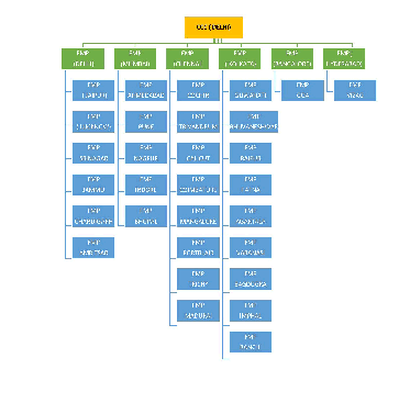
Airports Authority of India (AAI) has established a Central Air Traffic Flow Management (C-ATFM) system in India. The C-ATFM network consist of a Central Command Center (CCC) at Delhi supported by Flow Management Positions (FMPs) at major Area Control Centres (ACCs) and ATC towers across the country. The CCC provides ATFM service in conjunction with the FMPs.

2.

Applicability of C-ATFM

2.1

The C-ATFM system provides ATFM services covering all the four Indian FIRs including the oceanic airspace areas of Bay of Bengal, Indian Ocean and Arabian Sea, designated to India for the provision of ATS Services. This is called Indian Air Traffic Flow and Capacity Management (ATFCM) area.

2.2

The CCC Traffic Flow Manager, using the C-ATFM system, may apply ATFM

Measures to flights which

• Depart and land within the Indian ATFCM area

2.3

ATFM measures are not applicable to flights which

• Depart from Indian ATFCM area for destinations which are outside the Indian ATFCM area.

• Arrive at airports within Indian ATFCM area from airports which are outside Indian ATFCM area.

3.

ATFM Process

3.1

ATFM - CDM (Collaborative Decision Making) Concept

3.1.1

The functioning of C-ATFM involves ATFM community participation, which includes air space users, airport operators, military, regulator (DGCA) and Airports Authority of India.

3.1.2

Members of ATFM community participate and collaborate in the planning, development, use, regulation, operation and maintenance of the ATFM system, within the framework of the concept of Collaborative Decision Making (CDM), elucidated by ICAO in the Global Air Traffic Management Operational Concept (Doc. 9854 AN/458), Global Air Navigation Plan (Doc. 9750 AN/963) and Manual on Collaborative Air Traffic Flow Management (Doc 9971 AN/485).

3.1.3

The application of CDM will facilitate to reach an acceptable solution in which requirements of all participants and effective operation of ATM system will be considered.

3.2

ATFM Implementation in India

3.2.1.

Airports Authority of India, in accordance with ICAO guidelines on PANS-ATM has established Central Air Traffic Flow Management system (C-ATFM) in India.


3.2.2.

In phase I, Flow Management Positions (FMPs) of six airports namely Delhi, Mumbai, Bengaluru, Chennai, Kolkata and Hyderabad, which account for 60 % Air Traffic handled at Indian Airports, have become operational to provide support to Central Command Center (CCC).


3.2.3.

In Phase II, FMPs will be made operational in a phased manner at additional 30 airports. The locations of the FMPs is provided in para 13. The FMPs will be operational as per the operational watch hours of the respective airport.


3.2.4.

The C-ATFM system, provides AAI and Aircraft Operators with significant capabilities to perform strategic, pre-tactical, and tactical ATFM and CDM associated with departures and arrivals into the six airports. The Phase II capabilities will include extending flow management capabilities to additional 30 airports and airspace sectors.


3.2.5.

The C-ATFM system is designed for easy access through web based application. Authorized users are able to access the C-ATFM system through secured log in process and participate in the CDM process.

3.3.

C-ATFM Operating Process

3.3.1.

Strategic Slot Allocation

3.3.1.1.

The Jt. Director General, DGCA approves the summer and winter flight schedules for domestic scheduled airlines on bi-annual basis under the provision of Rule 140A of the Aircraft Rule 1937. The Summer Flight Schedule is valid for a period from last Sunday of the month of March to last Saturday of the month of October of every year whereas the Winter Flight Schedule is valid from last Sunday of the month of October to last Saturday of the month of March ever year.

3.3.1.2.

A slot coordination meeting is convened by AAI, inviting all the stakeholder’s participation under the Chairmanship of DGCA. During the slot coordination meeting, filed slots for each airport by airlines are discussed in respect of runway closure and other safety concerns and in accordance with guidelines for slot allocation issued by Ministry of Civil Aviation & worldwide slot allocation guideline issued by IATA.


3.3.1.3.

Based on the deliberations during the meeting such as agreement on slot finalisation between airline and airport operators, redressal of call sign conflicts & block hour related issues, approval to the airline-wise flight schedule is accorded. The approved flight schedule forms the basis for strategic air traffic flow management planning.

3.3.2.

Demand-Capacity Balancing in ATFM

3.3.2.1.

With access to approved flight schedules, Flight Plans and operational flight data from AAI’s ATC automation system, strategic and pre-tactical demand predictions are provided by the C-ATFM (“SKYFLOW”) system to determine periods of excess demand compared to the Declared/ Practiced airport Capacity.

3.3.2.2.

C-ATFM operates on the principle of primarily making efforts towards efficient capacity management followed by application of ATFM regulation (delaying aircraft on the ground).

3.3.2.3.

C-ATFM will, when necessary, apply ATFM measures such as Ground Delay Programs (also known as Airport Delay Program-ADP) and/or Ground Stop (also known as Airport Stop Program- ASP) Programs, by issuance of “Calculated Take Off Time” (CTOT). ATFM Measures are collaborated with airspace users and airport operators as an integral part of the CDM process.

3.3.2.4.

Alternative ATFM measures, which will be operational in phase II, include re-routing of aircraft both strategically and tactically, fix balancing, Miles-In-Trail (MILT), Minutes-In-Trail (MINT) and Level Capping.


3.3.2.5.

Once an ATFM Measure is implemented, CCC will monitor updated demand predictions. Updated predictions are driven by tactical flight data updates from the automation systems as well as flight specific updates provided by aircraft operators.


3.3.2.6.

Airspace Users (AU)/Aircraft Operators (AO) are provided capabilities to monitor the SKYFLOW system and may request CCC for schedule management adjustments (e.g., slot substitutions) to optimize their operations consistent with the available capacity.


3.3.2.7.

A web portal access to the SKYFLOW system is provided via www.atfmaai.aero which is compatible with all the browsers. The SKYFLOW system provides the stakeholders a common situational awareness of the current ATFM status and information about ATFM measures in India. (A hyperlink to the ATFM system is provided on www.aai.aero). AU/AOs will be able to view flight details and their own slots during an ATFM Measure. ATS Units and aerodrome operators will also be able to view all flights arriving and departing from their aerodrome.

3.3.2.8.

C-ATFM system provides post operational reports to help AAI and their stakeholders to evaluate system performance and lessons learnt.

3.4.

ATFM Regulation Process

3.4.1.

At times when air traffic demand exceeds available capacity, a regulation (ATFM measure) will be applied by C-ATFM system and departure times will be issued in the form of a Calculated Take off Time (CTOT). This is facilitated by the SKYFLOW automated system algorithm at the CCC.

3.4.2.

For flights subject to a regulation, CCC will allocate a CTOT, not later than two hours before Estimated off- Block Time (EOBT). This information can be accessed through SKYFLOW log-in. The information may also be sent to the aerodrome operator, ATC and the Aircraft Operator as an e-mail message.

3.4.3.

Recipients of the CTOT messages as above are required to comply with the issued departure slot time. The AUs shall arrange their flights so as to take-off within the slot tolerance window (-5 to +10 minutes of the CTOT). ATC shall ensure that the departures comply with the CTOT regulations so that excessive holdings and diversions are avoided.

3.4.4.

When AUs are unable to meet the departure slot window, they shall inform respective ATC unit with a revised EOBT. ATC or/and the local FMP will in turn inform CCC about the revised EOBT and when possible will receive a revised CTOT to be passed on to the aircraft.

3.4.5.

Full details of the ATFM regulation process and procedures related to Flight Planning and C-ATFM are published in the ATFM User’s Manual section of the C-ATFM Operations handbook.

4.

Flight Planning in the context of ATFM

4.1.

All Airline Operators should adhere to Flight Planning requirements as stated below:

a) Flight plans shall be submitted at least 3 hours before the EOBT;

b) The window for filing FPL is between 3 Hours and 120 Hours (Five days) before the EOBT. Earlier filing of FPL will give a realistic demand data to the CCC and hence the requirement of ATFM measures can be identified early for better planning. Late filing of a flight plan will lead to inaccuracies in predicting the demand and may lead to a delay;

c) All flights departing, arriving or overflying India subject to a change in an EOBT of more than 15 minutes shall notify the change to the C-ATFM system through AFTN message. All ATS messages such as FPL, CNL, DLA, CHG shall be addressed to VIDPCTFM also.

d) It is in the best interest of Aircraft Operators to initiate prompt revisions or cancellations, thus permitting the ATFM system to maximize use of available capacity and minimize delay. The later the revision is made the greater is the probability of a delay.

e) Originators of all NOTAM, AIS and MET messages pertaining to Indian airports/FIRs shall include VIDPCTFM additionally in the addressee list of such messages.

f) Full details of flight planning requirements are included in the ATFM User’s Manual section of C-ATFM Operations Handbook.

4.2.

Flights Exempted From ATFM Measure

4.2.1.

The following flights are exempted from the ATFM Measures:

a. Flights experiencing an emergency, including aircraft subjected to unlawful interference;

b. Flights in search and rescue or fire-fighting missions;

c. Urgent medical evacuation flights specifically declared by medical authorities where flight delays would put the life of the patients at risk;

d. Flights with “Head of State” status;

e. Military Aircraft; and

f. Other flights specifically identified by appropriate authorities.

Note: After medical flights have completed their mission, they shall be subject to ATFM measures. Scheduled passenger transfer flights are, by their nature, non-urgent and should not be given priority under normal operational situation.

4.2.2.

Flights exempted from ATFM measures shall indicate the exemption in their flight plan (Field 18 - STS/HEAD, STS/MEDEVAC etc.).

4.3.

Modification of EOBT

4.3.1.

In order to comply with a CTOT, Aircraft Operators should plan its off-block time consistent with the CTOT, taking into account the taxi time;

4.3.2.

Any change to the EOBT of more than 15 minutes (+ or -) for any IFR flight shall be communicated to ATC and ATFM, by appropriate ATS message;

4.3.3.

If the original EOBT can no longer be met, then the AO shall communicate the new EOBT by use of a DLA or CHG message. When an AO submits an amendment message to ATC and ATFM, they must always give an EOBT which indicates the time the AO wants to be off-blocks;

4.3.4.

The procedure to be followed to modify the EOBT is as follows:

a) To amend the EOBT to a later time, a DLA or CHG message shall be sent to ATC and CATFM;

b) To amend the EOBT to an earlier time, a CNL message must be sent to ATC and CATFM which cancels the earlier FPL. It shall be followed five minutes later by a new flight plan with new EOBT indicated.

4.3.5.

Whenever the EOBT of a flight is changed sufficiently in advance, the SKYFLOW system may allocate a revised CTOT. In any case, the CTOT of the flight will always be later than the new EOBT plus the taxi-time.

4.3.6.

However, if the EOBT is revised closer to the actual time of operations, ATFM system will not be in a position to issue a revised CTOT. In this case the flight is treated on its merits and may be subjected to tactical ATC delay in coordination with FMP/CCC.

5.

Responsibilities of Aircraft Operators

5.1.

Aircraft operators shall

5.1.1.

Provide RPL data to ATS units and subsequent changes if any in RPL, as per laid down procedures;

5.1.2.

Update RPL data and subsequent changes in the SKYFLOW system after approval of schedule by DGCA;

5.1.3.

Ensure that the details given in the FPL are consistent with that of the RPL/ Flight Schedules;

5.1.4.

Monitor ATFM Daily Plan (ADP);

5.1.5.

Comply with a CTOT;

5.1.6.

Comply with the provisions of filing of flight plans and for amending of EOBT; and

5.1.7.

Obtain ADC number from IAF MLU if necessary, in case of revised EOBT.

6.

Responsibilities of FMP

6.1.

Each FMP shall:

6.1.1.

Disseminate ADP and CTOTs to the concerned ATC centres in a timely manner.

6.1.2.

Coordinate with CCC for cancellation of CTOTs or for any contingency events affecting capacity.

6.1.3.

Participate in national CDM.

7.

Responsibilities of Air Traffic Services

7.1.

Concerned ATC centre shall:

7.1.1.

Facilitate/monitor CTOT compliance by aircraft;

7.1.2.

Coordinate with the respective FMPs for revisions to EOBT when flights are unable to adhere to their slot;

7.1.3.

Keep FMP informed about any changes or occurrences that can affect the capacity of the aerodrome; and

7.1.4.

Accord priority for push-back /start/departure to aircraft subject to CTOT.

8.

Responsibilities of Airport Operator

8.1.

Airport operator shall:

8.1.1

Provide, at the earliest opportunity, but at least 14 days in advance, details of any event that may lead to an hourly increase in demand, e.g. sports event, trade fair, Government/Public meeting, air show etc;

8.1.2

Send such Event-related information to: Email: ccc_catfm@aai.aero Fax: + 91-11-25652131;

8.1.3

Coordinate with local ATC and FMP for allocation/revision of airport slots;

8.1.4

Notify concerned FMP of events/maintenance works etc., that may impact airport capacity;

8.1.5

Participate in the C-ATFM activities and CDM and;

a) Provide updated flight schedules to CCC for accurate demand predictions;

b) Participate in CTOT communication flow.

9.

Role of Military as a CDM Participant

9.1

C-ATFM operating concept envisages active civil-military coordination & cooperation on sharing of data and other resources, thus enabling an optimal use of national airspace system. Further it may be noted that, in case of exigencies, the Defence liaison at CCC will be the focal point of contact for all required coordination between C-ATFM and Defence.

9.2

Military ATC unit shall liaise with the respective airports/ concerned Defence authorities for information on Special User Airspace

10.

ATFM Operational Letters of Agreement

10.1

The roles and responsibilities of all stakeholders for the collaborative decision making of ATFM are being jointly developed and agreed upon. The applicable common rules will be published in a document called “Common Business Rules” (CBR).

11.

ATFM Documentation

11.1

Specific C-ATFM procedures and information will be available in the C-ATFM Operations Handbook published by the ATFM Directorate of AAI and can be downloaded from: http://www.atfmaai.aero

11.2

The C-ATFM Operations Handbook containing comprehensive information and procedures on ATFM includes:

11.2.1

General and C-ATFM Systems: this section contains details of the C-ATFM and CCC organization, area of responsibility of various stakeholders and a description of CATFM systems.

11.2.2

The ATFM User’s Manual: this is a self-contained user’s manual for aircraft operators and ATC units describing C-ATFM operating procedures in the context of the SKYFLOW system.

11.2.3

Flight Planning User’s Manual: this is a self-contained user’s manual describing operating procedures for flight plan filing in the context of ATFM.

12.

General ATFM Enquiries


12.1 General ATFM enquiries should be addressed to:

Executive Director (Air Traffic Flow Management)

Airports Authority of India, Rajiv Gandhi Bhavan

Safdarjung Airport, New Delhi -110003

Phone: +91-11-24610776

Fax: +91-11-24657898

Email: edatfm@aai.aero

13.

Location of FMPs


IMMAGINE DA METTERE

14.

Flexible Use of Airspace

14.1

Introduction

14.1.1

Flexible Use of Airspace (FUA) is an airspace management concept based on the principle that airspace should not be designated purely as civil or military, but rather as a continuum in which all user requirements are accommodated to the greatest possible extent.

14.1.2

The Government of India approved implementation of Flexible Use of Airspace in India in March 2013.

14.2

Definitions

a) Airspace Management Cell (AMC) is a joint civil/military cell responsible for the day-today management and temporary allocation of national airspace under the FUA concept.

b) Airspace Use Plan (AUP) is an ASM message of NOTAM status notifying the daily decision of an Airspace Management Cell on the temporary allocation of the airspace within its jurisdiction for a specific time period, by means of a standard message format.

c) Approved Agency (AA) is a unit, which has been authorised by an Airspace User to deal with an Airspace Management Cell for airspace allocation and utilisation matters.

d) Centralised Airspace Data Function (CADF) is an ASM function performed by the National AMC (N-AMC) for consolidating the AUPs / UUPs published by the Regional AMCs (R-AMC) and publishing them on the ATFM portal as electronic AUP (eAUP) / electronic UUP (eUUP).

e) Collaborative Decision-Making (CDM) is a process whereby all ATM decisions, except for tactical ATC decisions are based on the exchange of all relevant information for transit operations between civilian and military parties.

f) Conditional Route (CDR) is a non-permanent ATS route or part of it that can be planned and used under special conditions.

g) General Air Traffic (GAT) encompasses all flights conducted in accordance with the rules and procedures of ICAO and/or the national civil aviation regulations and legislation.

h) Operational Air Traffic (OAT) encompasses all flights which do not comply with the provisions stated for GAT and for which rules and procedures have been specified by appropriate authorities.

i) Prior Coordination Airspace (PCA) is a portion of airspace of defined dimensions within which individual GAT is permitted to fly “off-route” only after prior co-ordination initiated by GAT controllers with OAT controllers.

j) Reduced Coordination Airspace (RCA) is a portion of airspace of defined dimensions within which GAT is permitted to fly “off-route” without requiring coordination between controllers.

k) Special Use Airspace (SUA) is the term used for airspace wherein activities must be confined because of their nature, or wherein limitations are imposed on aircraft operations that are not a part of those activities, or both. SUA is a generic term used to refer to Restricted Areas, Danger Areas, Prohibited Areas, TRA and TSA.

l) Temporary Reserved Area (TRA) is an airspace temporarily reserved and allocated for the specific use of a particular user during a determined period of time, through which other flights may pass with permission from Air Traffic Control (ATC).

m) Temporary Segregated Area (TSA) is an airspace temporarily reserved and allocated for the exclusive use of a specific user during a determined period of time, through which no other flights may pass.

14.3

FUA Organizational Structure

a) NHLAPB: Implementation of Flexible Use of Airspace is the responsibility of National High Level Airspace Policy Body (NHLAPB). NHLAPB is the high level body chaired by Secretary (Civil Aviation) and ex-officio members from Ministry of Defence (MoD), Indian Air Force (IAF), Indian Navy (IN), Indian Space Research Organization (ISRO), Directorate General of Civil Aviation (DGCA) and Airports Authority of India (AAI).

b) NAMAC: National Airspace Management Advisory Committee (NAMAC) is a national airspace management body that is constituted to provide assistance and advice to the NHLAPB in formulating the national ASM policy and carry out the necessary strategic planning work, taking into account the requirements of civil and military airspace users and ATS providers.

c) FUA Secretariat: FUA Secretariat is a working level body residing within Directorate of Airspace Management of AAI, which carries out necessary facilitation for implementation for FUA concept.

d) AMC: Airspace Management Cells (AMC) are joint civil/military cells responsible for the day-today management and temporary allocation of national airspace under the FUA concept. AMCs will be established at metro ATC centres across the country.

e) Airspace Users: Airspace Users include both civil and military users who coordinate with AMCs for pre-tactical and tactical allocation of temporary airspaces (TSA & TRA) and conditional routes (CDR).

14.4

Airspace Management under FUA

14.4.1

The FUA Concept is based on three levels of Airspace Management, which correspond with the associated civil / military ATM coordination tasks. The three levels of ASM have specific timeframes matching with the availability of associated FUA structures like TSA, TRA and CDR.

14.4.2

The three levels of ASM are:

a) Strategic ASM, also referred to as ASM Level 1,

a) Pre-Tactical ASM, also referred to as ASM Level 2, and

b) Tactical ASM, also referred to as ASM Level 3.

14.4.3

Strategic ASM (ASM Level 1) consists of a joint civil-military process for formulating the national ASM policy and to carry out the necessary strategic planning work for conducting airspace management activities, taking into account national and international airspace users’ requirements, within the framework of national security requirements. Strategic ASM activities include periodic review of national airspace and creation of airspace structures such as TSA, TRA and CDR. The procedures to be followed at pre-tactical and tactical ASM levels, the priority rules and the negotiation procedures for airspace allocation at these levels should be determined at the strategic level.

14.4.4

Pre-Tactical ASM (ASM Level 2) consists of the day-to-day management and temporary allocation of airspace by Regional and National AMCs. AMCs are joint civil/military ASM focal-points which have the authority to conduct ASM within the framework of the national airspace structures, priority rules and negotiation procedures as laid down by the NHLAPB. AMCs collect and analyse airspace requests from various airspace users. After coordination with stakeholders, the AMCs promulgate the airspace allocation as an Airspace Use Plan (AUP) and changes thereto as Updated Airspace Use Plans (UUP).

14.4.5

Tactical ASM (ASM Level 3) consists of the real-time activation, deactivation or real-time reallocation of the airspace allocated at ASM Level 2 and the resolution of specific airspace problems and/or traffic situations between civil and military ATS units and/or controlling military units and/or controllers, as appropriate.

14.5

Flexible Airspace Structures and Procedures

14.5.1

The FUA concept uses airspace structures and procedures that are particularly suited for temporary allocation and/or utilization, such as Conditional Routes (CDR), Temporary Reserved Areas (TRA), Temporary Segregated Areas (TSA), Reduced Coordination Airspace (RCA) and Prior Coordination Airspace (PCA). The use of these airspace structures is enabled through specific processes and procedures described hereafter.

14.5.2

Conditional Routes

14.5.2.1

A Conditional Route (CDR) is an ATS route or a portion thereof which can be planned and/or used under certain specified conditions only. CDRs permit the definition of more direct and alternative routes by complementing and linking to the existing ATS route network.

14.5.2.2

CDRs can be established through Strategic ASM (ASM Level 1) processes:

• through areas of potential temporary reservations (e.g. TRA or TSA), with opening/ closure conditions resulting from associated military activities; and/or

• to address specific ATC conditions (e.g. traffic restrictions or ATC sectorisation compatibility) with opening/closure conditions resulting from purely civil needs.

14.5.2.3

The properties of CDRs, including their categories, alignment and route designator, are published in AIP-India.

14.5.2.4

CDRs are divided into three categories according to their estimated period of availability and flight planning possibilities:

14.5.2.4.1

CDR1 - Permanently Plannable CDR

• CDR1 are available for flight planning during periods of time published in the AIP.

• When a CDR is expected to be available for most of the time, it should be declared as permanently plannable for stated time periods and published as CDR1 in the AIP.

• CDR1 can either be established on H 24 basis or for fixed time periods and/or at fixed flight level bands.

• The closure of a CDR1, which requires re-filing of the affected flight plans, has to be published in the form of a NOTAM with appropriate advance notification, not less than 7 days. The closure information should also be included in the relevant AUP / UUPs.

14.5.2.4.2

CDR2 - Non-Permanently Plannable CDR

• CDR2 may be available for flight planning. Flights may only be planned on a CDR2 in accordance with conditions published daily in the AUP/UUP.

• CDR2 form part of predefined routing scenarios depending on the allocation of associated AMC-Manageable Areas or for addressing specific ATC conditions.

• CDR2 availability can be requested by the Flow Management Positions (FMPs) or ACCs to adjust traffic flow, when a capacity shortfall has been identified and after consideration of relevant ATC factors.

• CDR2 when not available according to AUP/UUP publication may also be managed tactically, whenever conditions allow short-notice usage, subject to coordination between responsible ATS and/or controlling military units.

14.5.2.4.3

CDR3 - Not Plannable CDR

• CDR3 are not available for flight planning. Flights must not be planned on these routes but ATC units may issue tactical clearances on such route segments, when made available.

• CDR3 are those CDRs that are expected to be available at short notice when the pre-notified activity in the associated AMC-Manageable Areas has ceased, or for addressing specific ATC conditions.

• After coordination with the associated military ATS unit or Controlling Authority of the associated AMC-Manageable Area(s), the controller responsible may offer an aircraft a short-notice routing through the area using a predefined CDR3.

• CDRs3 are published in AIPs as CDRs usable on ATC instructions only and are not subject to pre-tactical allocation by AMCs.

14.6

Temporary Airspace Reservation and Allocation

14.6.1

Temporary Airspace Allocation (TAA) process consists of the allocation of airspace of defined dimensions, either notified in AIP as “AMC Manageable” Areas (TRA / TSA / AMC-Manageable Danger/Restricted Areas) or published through NOTAM as user-defined temporary Danger or Restricted areas, which may also be AMC manageable. Airspaces designated as Permanent Restricted Areas (PRA) are not AMC-manageable.

14.6.2

Temporary airspaces are established in response to the need for civil, military, R&D, training, test flights or activities of temporary nature, in accordance with national policy and allocated by AMCs for specific activities. Temporarily reserved airspaces, which are published in AIP, can be classified into the following two types, based on whether the airspace offers transit possibility to non-participating aircraft:

a) Temporary Reserved Area (TRA)

b) Temporary Segregated Area (TSA)

14.6.3

The fundamental difference between TRA and TSA lies is in the fact that, if, due to the nature of the activity, segregation is needed to protect participating and non-participating traffic, only TSA applies. Tactical crossing of the area should not be allowed when the TSA is activated. TRA allows tactical crossing of the area in coordination with the Controlling Authority.

14.6.4

In the context of the FUA Concept, all TRAs and TSAs are airspace reservations subject to management and allocation at ASM Level 2 through AMCs.

14.7

Priority Rules

14.7.1

The following general rules, as detailed below, shall apply in determining the order of priority of aircraft operations:

a) An aircraft which is known or believed to be in emergency compelling it to land without delay; e.g. aircraft experiencing engine failure, acute shortage of fuel or total communication failure.

b) Military fighter flights invariably experience shortage of fuel if not allowed to proceed as per the planned operations. Any alteration to their optimum flight profile (flight path/level) should be avoided / minimized in general. The ground time limitations of military fighter aircraft entail that the departures are accommodated from intended Civil/Military aerodromes without any delay.

c) An aircraft engaged in a live scramble.

d) An aircraft carrying sick or injured persons, requiring urgent medical attention or carrying out approved medical evacuation (Medical Flights).

e) An aircraft carrying VVIP as laid down in procedures for their handling.

f) An aircraft proceeding on Search and Rescue missions.

g) Military flight carrying out large integrated formations in military exercises.

h) Aircraft / RPA in approved urgent operational military commitment which has been coordinated with appropriate ATC Centres.

i) Aircraft on large scale weather deviations.

j) Aircraft landing at alternate aerodromes after diversion due adverse operational or weather conditions at their intended destination.

14.8

Pre-tactical Airspace Management - Establishment of AMCs

14.8.1

Pre-Tactical ASM at ASM Level 2 consists of the day-to-day management and temporary allocation of airspace through National or Regional AMCs.

14.8.2

A National Airspace Management Cell (N-AMC) in Delhi and four Regional AMCs (R-AMCs) in the metro Area Control Centres at Chennai, Delhi, Kolkata and Mumbai respectively, established with adequate representation from civil and military ANSP/ATSP, DGCA (in N-AMC only) and airlines shall act as the ASM Level 2 focal-points. The four R-AMCs will be established in a phased manner as explained in Section 21.11.

14.8.3

R-AMCs have been vested with the authority to conduct the ASM function within the framework of national airspace structures, priority rules and negotiation procedures approved by the NHLAPB. R-AMCs (and N-AMC, when required) have adequate authority to efficiently resolve conflicting airspace requests and minimize the necessity for referral to higher authorities.

14.8.4

The N-AMC shall oversee the functions of the R-AMCs and shall act as the facilitator for any negotiation required between R-AMCs and the civil / military airspace users. The N-AMC has been collocated with Central Command Centre (CCC) of the Central Air Traffic Flow Management (CATFM) system and will perform Centralized Airspace Data Function (CADF) functions.

14.8.5

R-AMCs and N-AMC shall engage in Collaborative Decision Making (CDM), within the framework of FUA and within the powers vested in them, by the NHLAPB.

14.8.6

Organizational Structure of the National AMC

14.8.6.1

N-AMC comprises of ATC officers from AAI, IAF & Indian Navy, airline operators, airport operators and DGCA.

14.8.6.2 N-AMC is collocated with CATFM-CCC, presently located in the 4th Floor of the new ATS Complex, IGI Airport, New Delhi.

14.8.7

Organizational Structure of the Regional AMCs

14.8.7.1

R-AMCs will comprise of ATC officers from AAI, IAF & Indian Navy, airline operators and airport operators.

14.8.7.2

The R-AMCs, when established, shall be functionally integrated with the corresponding FMPs. The CDM process will take place between the members of each R-AMC for arriving at decisions during pre-tactical activities, which will be communicated to the N-AMC (CCC) through the respective FMPs.

14.9

Allocation and Notification Process at ASM Level 2

14.9.1

General Provisions

14.9.1.1

Agencies responsible for airspace activities should submit their requests for the allocation of temporary airspaces and conditional routes (TSA / TRA / AMC-Manageable Restricted / Danger Areas and CDR) to the appropriate R-AMC in adherence with the conditions laid down for the TSA/TRA/CDR activation and deactivation. Requests for allocation of temporary airspaces shall be submitted by the Approved Agencies (AA) on behalf of the Controlling Authorities of the concerned temporary airspaces. Similarly, request for allocation of CDRs shall be submitted by the concerned ACC or FMP.

14.9.1.2

After the R-AMC has received, evaluated and de-conflicted the airspace allocation requests, it will convey the allocation plan in advance by publishing an Airspace Use Plan (AUP) on a daily basis. Airspace Use Plan (AUPs) activates Conditional Routes (CDRs) and allocate TSA / TRA / AMC-Manageable Restricted & Danger Areas for specific periods of time.

14.9.1.3

If necessary, changes to pre-tactical airspace allocation is effected by R-AMCs through the publication of Updated Airspace Use Plan (UUP). This Plan notifies the changes to the airspace allocation on the day of operations. The Airspace Use Plan (AUP) and the Updated Airspace Use Plan (UUP) will be published in the prescribed format. The current UUP will completely replace the previously published AUP / UUP.

14.9.1.4

The AUPs published by the R-AMCs are collected by the N-AMC. The N-AMC has been vested with the responsibility of the compilation of AUPs/UUPs published by the R-AMCs and publishing the corresponding eAUP / eUUP in the ATFM portal.

14.9.2

Airspace Requests

14.9.2.1

Units that represent airspace user entities (e.g. squadrons), which need to utilize TRAs / TSAs or AMC-Manageable Restricted / Danger areas are designated as Approved Agencies (AA) by the respective organisations such as IAF, Indian Navy and Indian Army. AAs are permitted to negotiate with R-AMCs for airspace allocation on behalf of the airspace user entities under their jurisdiction. The airspace user for whom the TSA or TRA has been created shall be considered as the priority user for that airspace. However, R-AMC will still be vested with the authority to negotiate with the AA representing the airspace user entity for accommodating allocation request by another user, especially when the requirement of the latter is one of national importance. In general, the requirement of highest national importance will be considered in case of any conflicting demands.

14.9.2.2

Approved Agencies are required to:

a) plan submission of airspace use activities in advance so as to be able to notify their needs for airspace to the R-AMCs on the day before the activity;

b) submit to the R-AMC, on the day before the proposed activity (D-1), requests for airspace utilization and allocation;

c) inform R-AMC of any change in the proposed activity, including cancellations, for the promulgation of UUP;

d) submit a new request for airspace allocation to the R-AMC for the promulgation of UUP; and

e) ensure, on the day of the activity, that the airspace usage is in accordance with the airspace allocation.

14.9.3

Allocation of Conditional Route

14.9.3.1

Requests for allocation of CDRs are based on capacity needs identified by the ACCs and FMPs, in coordination with ATFM CCC in the pre-tactical ATFM phase. ACC/FMP should forward the requests for allocation of specific CDR2 routes to the appropriate R-AMC in the pre-tactical stage (D-1).

14.9.4

Specific Provisions for Airspace Allocation by AMCs

14.9.4.1

The agencies (military or non-military) for which TSAs/TRAs have been created will be considered as priority users consequent to receipt of their requests.

14.9.4.2

The requests for airspace allocation may also contain the priority of a mission-critical exercise from the military authorities and the AMCs shall handle such request by assigning them a suitably high level of priority owing to national security.

14.9.4.3

The R-AMCs shall also collect and analyse all airspace requests which may require temporary airspace segregation, including airspace allocation decisions taken at ASM Level 1 in respect of major military exercises, air shows etc.

14.9.4.4

The R-AMCs shall also analyse the CDR availability requests together with the traffic demand, anticipated ATC capacity problems and expected delay information received from the FMP(s).

14.9.4.5

The R-AMCs shall resolve conflicting requests for TSA/TRA and CDRs utilizing all relevant information, and in general, according priority to national requirements.

14.9.4.6

The R-AMCs shall respond to any additional request for assistance by the CCC for Flow Management, the ACC/FMPs and Approved Agencies or matters arising from major ATS routes inconsistencies or unexpected events.

14.9.4.7

The AMCs are suitably represented by the military airspace users and the decisions made are collective and collaborative.

14.9.4.8

N-AMC and R-AMCs act as ASM Level 2 national and regional ASM focal points, improve civil-military coordination and manage the airspace to ensure its flexible use.

14.9.4.9

AMCs conduct Pre-Tactical ASM Level 2 airspace allocation and management operations in a decisive, timely and efficient manner and resolve conflicting airspace requests and ASM Level 2 problems.

14.9.4.10

After the R-AMC has completed the allocation process through the promulgation of the AUP, modification of the airspace allocation might be necessary. Modifications of the airspace allocation are effected by the R-AMC through an Updated AUP (UUP). UUP will consist of any cancellations or changes within the allocated lateral and vertical limits and the time slot. R-AMC may also consider new requests for allocation, if it does not affect the use any previous allocated airspace or CDR.

14.9.4.11

The R-AMCs will be provided with communications equipment required to facilitate communication/coordination with all appropriate partners (AAs, FMPs, CCC and other R-AMCs). This is possible through the colocation of the R-AMCs in the Metro ATC Centres, which are already equipped with a communication network. The communication channels to be used shall be on mutually agreed terms between the agencies involved.

14.9.5

Aircraft Operator’s (AO) FUA Responsibilities

14.9.5.1

In order to take advantage of available CDRs, AOs are required to submit their flight plans taking into account the latest available information. Flight plans should include route changes and the use of CDRs pertaining to a particular flight.

14.9.5.2

AOs shall have suitable and adequate means of internal distribution of the revised flight plan to all units, especially the pilot-in-command.

14.9.5.3

Use of CDR1

14.9.5.3.1

CDR1 are plannable as permanent ATS routes subject to the conditions published in AIP.

14.9.5.3.2

Any CDR1 closure which requires re-filing of flight plan is published through NOTAM at least 7 days in advance and, for safety reasons, published in AUP/UUP and notified again to the operators by eAUP/eUUP. In such case, any flight plan which uses the CDR1 portion during the affected period is to be cancelled or changed in accordance with the procedures laid down in the AOs’ Operations Manual.

14.9.5.3.3

In case a CDR1 closure is cancelled, a new NOTAM is required to cancel/ replace the existing one. The current AUP / UUP will also indicate the cancellation of the CDR1 closure.

14.9.5.3.4

In the very unlikely event of a short notice unavailability of a CDR1, flights will be instructed by ATC to use alternative routes. Operators should consider the implications of the possible use of the alternate ATS routes published for each CDR1 in the AIP.

14.9.5.4

Use of CDR2

14.9.5.4.1

Flights on CDR2 can only be planned when the CDRs are made available through AUP/UUP. In this respect, the UUP could also notify the closure of CDR2 declared available in AUP and/or previous UUPs. The closure is notified by deleting the (available) CDR2 from the previous AUP/UUP and notified to the AOs by eAUP/eUUP. AOs should also refer to the NOTAMs and ATFM Daily Plan (ADP) for additional information regarding the specific utilization of available CDR2.

14.9.5.4.2

Whenever an operator wishes to take advantage of particular available CDR2 or is required by the Civil ATS unit to use particular CDR2, an individual flight plan should be submitted. It should contain in Item 15 the available CDR2 to be followed. Under these circumstances, any associated RPL shall be cancelled or changed in accordance with the procedures laid down in the AO’s Operations Manual.

14.9.5.5

Use of CDR3

14.9.5.5.1

CDR3 are published in AIP as CDRs that are usable on ATC instructions only. Therefore, flights cannot be planned in advance on CDR3.

14.10

Pre-tactical (ASM Level 2) Information Management

14.10.1

Specific ASM Messages for ASM Level 2 Decisions

14.10.1.1

Airspace Use Plan (AUP)

14.10.1.1.1

The effective application of FUA Concept requires ASM Level 2 airspace allocation decisions to be promulgated daily in an efficient, timely and accurate manner by each R-AMC by means of Airspace Use Plan messages (AUP).

14.10.1.1.2

R-AMCs will publish AUP in the form of a NOTAM as soon as possible and not later than by or 1500 IST (0930 UTC) to cover the 24 hour time period between 0000 to 2359 UTC the next day (0530 IST the next day to 0529 IST the day after). Several AUPs can be sent in one sequence on the last day before the closure of the R-AMC to cover each day of a weekend or a holiday, if required, but with a maximum of seven consecutive days. The AUP shall also be transmitted by the R-AMC through at least one alternate means (FAX / email) to AOs, AAs, ACCs/FMPs, other R-AMCs and the N-AMC.

14.10.1.1.3

The Indian ATFM system is expected to achieve, in near future, the capability of exchanging FUA messages between AAs, ACCs/FMPs, R-AMCs, N-AMC/CCC and AOs through the CATFM web portal. The web portal will also display eAUPs / eUUP, updated on real-time basis.

14.10.1.2

Updated Airspace Use Plan (UUP)

14.10.1.2.1

After the R-AMC has completed the allocation process, modification of the airspace allocation might be necessary in order to take advantage of any cancellation or modification of previously allocated airspace structure(s). This may also have to be resorted to in case of sudden and unexpected requirements of military for additional activation of TRAs/TSAs and/or increased timings for already activated TRAs/TSAs which may lead to closure of certain routes or portions of routes already allocated. Changes to the airspace allocation will be effected by the R-AMC through UUPs.

14.10.1.2.2

UUPs will replace the current AUP and previous UUPs according to the validity time described in the procedure. It reflects the new plan with the aim of improving ATC capacity and reducing aircraft delays through the more efficient use of airspace and also for accommodating tactical military requirements.

14.10.1.2.3

UUP is published in the form of a NOTAM in the same common format of the AUP. The UUP information published by R-AMCs will be used by CCC to publish eUUPs.

14.10.1.2.4

UUP is also be transmitted by the R-AMC through at least one alternate means (FAX / Email) to the AAs, ACCs/FMPs, AOs, other R-AMCs and N-AMC. However, UUP is not published when there are no alterations to the current AUP/UUP.

14.10.1.2.5

R-AMCs must be informed of any proposed activation of Danger (D) and Restricted (R) Areas within Indian airspace. If the proposed activation has been promulgated through a NOTAM, the R-AMC should take the NOTAM into consideration while carrying out the airspace allocation process in pre-tactical and tactical stages (for issue of UUPs on D day, if required). The R-AMCs need not reproduce the contents of NOTAMs in the AUP/UUPs.

14.10.2

ASM Level 2 Timetable

14.10.2.1

Up To 48 Hours in Advance

14.10.2.1.1

Up to 48 hours in advance of the day of operations, the R-AMCs, through the associated FMPs/ACCs and in coordination with the CCC, should assess the expected traffic forecast for the particular day, identify and highlight capacity shortfalls, and agree on the traffic flow adjustment requirements that will be requested on the particular day of operations.

14.10.2.2

The Day before Operations (D-1)

14.10.2.2.1

Before 1100 IST (0530 UTC) on the Day before Operations:

a) the FMPs, along with the concerned ACCs, should compare the CATFM CCC operational requirements for traffic flow adjustment with relevant ACC factors such as sector handling capability, equipment constraints, staff availability and operational factors, and determine the corresponding CDR2 and/or for specific airspace configuration requirements;

b) the ACCs/FMPs should send the CDR2 allocation request and/or specific airspace configuration requests to the R-AMCs, with details of traffic forecasts, capacity shortfalls and delay predictions;

c) the AAs should collect all airspace user requirements for CDRs, TRAs/TSAs, AMC-manageable Restricted / Danger Areas, for the 24-hour period of the day of operations (0530 IST on D to 0529 IST on D + 1) and submit them as the civil/military Airspace Requests to the respective R-AMCs; and

d) the managers of designated Restricted and Danger Areas should advise the R-AMCs of the details of any reduced utilization of these areas.

14.10.2.2.2

Before 1500 IST (0930 UTC) on the Day before Operations:

a) the R-AMCs should collect, collate and analyse all airspace requests, resolve conflicts through negotiation and coordination, respond to any additional requests to resolve route inconsistencies, and decide on allocation of CDRs, TSAs and TRAs in accordance with priority rules established by NHLAPB;

b) the R-AMCs should compose Draft AUP after effecting coordination with other R-AMCs, if required. The R-AMCs should forward their draft UUP to N-AMC by 1300 IST (0730 UTC) at the latest. Between 1300 and 1400 IST (0730 and 0830 UTC), the N-AMC/ CCC should evaluate the impact on the network of the “draft” airspace allocation in close coordination with FMPs

and R-AMCs concerned, identify optimal scenarios and forward proposals to relevant R-AMCs and FMPs. A scenario may contain recommendations on change in CDRs/TRA/TSAs availability details (e.g. flight level band, availability time), sector reconfiguration, etc.;

c) between 1400 and 1500 IST (0830 and 0930 UTC), the R-AMCs should consider the advice/alternatives proposed by the N-AMC and coordinate proposed changes with the Approved Agencies (AAs) that requested airspace reservations, if required. The final airspace allocation decision remains the responsibility of the R-AMC concerned;

d) by 1500 IST (0930 UTC), R-AMCs should promulgate the AUPs in the form of NOTAM for the 24-hour period from 0000 to 2359 UTC on the day of operations (0530 IST D to 0529 IST D+1); and

e) The R-AMCs should send the AUPs through at least one alternate means (FAX / Email) to AAs, FMPs, ACCs, other R-AMCs and AOs.

14.10.2.2.3

Before 1600 IST (1030 UTC) on the Day before Operations:

a) The N-AMC should consolidate the AUP information received from various R-AMCs and ensure that it is published in the ATFM web portal as eAUP.

14.10.2.2.4

After 1600 IST (1030 UTC) on the Day before Operations:

a) AOs should file or re-file their FPLs according to the airspace situation promulgated through AUPs / eAUP.

14.10.3

Alteration of AUP via UUP publication on D-1

14.10.3.1

Airspace Users that have requested airspace allocations should advise the R-AMC about any change in the previously submitted airspace allocation request through the respective AAs. This will enable the associated CDR to be available for additional period(s) than that planned in the earlier AUP.

14.10.3.2

When required, the R-AMC should inform the FMP/ACC and the N-AMC about the new airspace opportunities through an UUP:

a) as from the AUP publication (1500 IST), the Airspace Users that requested airspace allocations should advise the respective AAs, which in turn will inform the respective R-AMC before 1730 IST (1200 UTC), about changes in their planning for the next day, if any (e.g. activity completed earlier than planned, cancelled or reduced in time or volume, etc.);

b) upon reception of a such information, the R-AMCs should check if the airspace is needed by another user;

c) when required, and if there is no requirement for use of that volume of airspace from other users, R-AMCs should inform N-AMC/CCC regarding the intention to lift/decrease airspace segregations (in time and/or space) via the promulgation of UUPs at 1700 IST (1130 UTC) and / or 1800 IST (1230 UTC), as per requirement, to inform stakeholders of the opportunity of additional CDR availability; and

d) The UUPs provide information on the changes starting from 0530 UTC on D to 0529 IST on D+1. Any UUP promulgated by R-AMC should contain full information on airspace allocation, completely replacing the previously issued AUP / UUP.

14.10.4

Activities on the Day of Operations

14.10.4.1

On the day of operations the following actions are applicable:

a) Airspace users should utilize the TRAs, TSAs and other AMC-manageable structures in accordance with the latest AUP/UUP promulgated on D-1 or anytime thereafter;

b) ACCs should utilize the CDR1 and CDR2 in accordance with the latest AUP/UUP; and

c) AOs should flight plan the CDR1 in accordance with AIP /NOTAM and CDRs2 according to the latest AUPs/UUPs.

14.10.4.2

On the Day of Operation (D), Airspace Users that requested airspace should advise the AAs about any change in their planned activities (e.g. activity completed earlier than planned, cancelled or reduced in time or volume, etc.) or in exceptional circumstances, any additional requirements in terms of time/airspace. AAs will, in turn, inform the corresponding R-AMCs if functional, or the affected ACC / FMP, regarding the change. This will facilitate the associated CDR to be available / unavailable for additional period(s) than that planned in the AUP/UUP.

a) Upon reception of such information, the concerned R-AMC should check if airspace is needed by another user(s); and

b) The R-AMC will inform FMP and CCC about the new airspace opportunities and publish additional UUPs, if required, from 0900 IST (0330 UTC) every hour up to 1800 IST (1230 UTC). Each UUP promulgated by R-AMC completely supersedes the previous one(s) for the particular day of operation.

14.11

Plan for Phased Establishment of AMCs

14.11.1

One of the major objectives of AMC is pre-tactical allocation of temporary FUA structures such as TRA, TSA and CDR. The allocation of FUA structures within each FIR will be carried out by the respective R-AMCs in coordination with the N-AMC.

14.11.2

As on date, India has published 27 TRA/TSA and 10 CDR. The limited number of FUA structures available for pre-tactical allocation does not require simultaneous establishment of four R-AMCs and one N-AMC. The existing number of FUA structures available for allocation can be managed by a single AMC.

14.11.3

It is planned to establish an R-AMC at Delhi, which will, for the time being, act as the R-AMC for all four FIRs. It is also planned that Delhi R-AMC will also function as N-AMC until such time more R-AMCs are established, which will in turn, be merged with CCC during the hours of operation of ATFM system.

14.11.4

More R-AMCs will be established in a phased manner depending on the number of FUA structures created, which will ensure optimum use of resources and manpower required for manning the AMCs.

14.11.5

The actual date of commencement of operations at the N-AMC and the R-AMCs and their working hours will be published through G-Series NOTAM.


15.

REDUCED VERTICAL SEPARATION MINIMUM (RVSM) - Policy and Procedures in Chennai, Delhi, Kolkata and Mumbai FIR.

15.1

Introduction

15.1.1.

The International Civil Aviation Organization (ICAO) Third Asia/Pacific Regional Air Navigation Meeting recommended that Reduced Vertical Separation Minimum (RVSM) should be introduced in the Asia/Pacific region. The Pacific and South China Sea RVSM implementation programs are complete, and application of RVSM will now expand west to the Bay of Bengal States and adjacent FIR. Aircraft operators and air traffic services (ATS) providers may gain significant benefits.


15.1.2.

ICAO Doc 9574 - Manual on Implementation of a 300M (1000Ft) Vertical Separation Minimum between FL290 and FL410 (both inclusive) contains explanation of RVSM.


15.1.3.

Benefits to be gained from RVSM include:


i) Adoption of an ICAO endorsed navigation requirement;


ii) Improved utilization of airspace for ATC conflict resolution;


iii) Fuel savings of ≅ 1% for flight closer to optimum cruise altitude; and


iv) Reduction in ground delays


15.2.

Content


i. Definitions


ii. Identification of RVSM Airspace


iii. Airworthiness and Operational Approval and Monitoring


iv. ACAS II and Transponder Equipage


v. In-flight Procedures within RVSM Airspace


vi. Special Procedures for In-flight Contingencies in Oceanic Airspace


vii. In-flight Contingency Procedures for Subsonic Aircraft Requiring Rapid Descent, Turn-back or Diversion in Oceanic Airspace


viii. Weather Deviation Procedures


ix. Special Procedures to Mitigate Wake Turbulence Encounters and Distracting Aircraft System Alerts in the Oceanic Airspace


x. Transition Areas


xi. Flight Planning Requirements


xii. Procedures for Operation of Non-RVSM approved Aircraft in Non-exclusive RVSM Airspace


xiii. Procedures for Operation of Non-RVSM approved Aircraft in climbing or descending through Exclusive RVSM airspace


xiv. Special coordination procedures for cruise operation of NON-RVSM approved aircraft in Exclusive- RVSM airspace


xv. Delivery Flights for Aircraft that are RVSM approved on delivery


xvi. Procedures for Suspension of RVSM


xvii. Guidance for Pilot and Controller for Actions in Event of Aircraft System Malfunction or Turbulence Greater than Moderate


xviii. Procedures for Air-Ground Communication Failure

15.3.

Definitions


Exclusive airspace - Airspace in Indian FIRs in which aircraft that are NONRVSM approved are not permitted to flight plan or operate-in unless the provisions of section 14 of this document apply. In regard to the application of RVSM procedures in Indian FIRs aircraft shall be categorized as follows:


i. RVSM Approved - Aircraft, which have gained a RVSM approval from the State of Registry or State of the Operator.


ii. Non-RVSM Approved - Aircraft which do not have a RVSM approval, or was RVSM approved but has become non-approved due to equipment failure.


iii. Approved Non-RVSM - Aircraft which have gained an approval to flight plan in exclusive RVSM airspace, as per special coordination procedures.


15.4.

Identification of RVSM airspace in Indian FIR and the Trasition plan.

15.4.1.

RVSM airspace is prescribed within the Chennai, Delhi, Kolkata and Mumbai FIR within controlled airspace between FL290 and FL410 (both inclusive).

15.4.2.

RVSM airspace in the Indian FIR will be designated as follows-


i. Exclusive RVSM airspace over Bay of Bengal


ii. Exclusive RVSM airspace over Arabian Sea in Mumbai FIR as described in Attachment D


iii. Non-Exclusive RVSM airspace as described in Attachment D

15.4.3.

Deleted

15.4.3.

The Flight Level Allocation Scheme (FLAS) for the Bay of Bengal Airspace, the Indian Continental airspace and Arabian Sea airspace are detailed below. Flight Level Allocation by ATC shall be in accordance with these tables. In addition, operators shall flight plan in accordance with these tables.

15.4.3.1.

FLAS for Bay of Bengal Oceanic airspace

15.4.3.1.1.

West Bound (H24)

Bay of Bengal

Flight level allocation

N877, P628, L759, P570, M300, N563, N571 and P574

FL280, FL300, FL340, FL360, FL380, FL400 are available

(FL360 is available subject to coordination

P646 and L507

All west-bound flight levels are available

P762, L301, N895, L645

FL320, FL360 are available

(FL360 available subject to coordination)

15.4.3.1.2.

East Bound (H24)

Bay of Bengal

Flight level allocation

N877, P628, L759, M770, P570, M300, N563, N571, P574

All east-bound flight levels are available

(except FL290)

P762, L645

FL290 is available as No Pre-Departure

Coordinated Level. All other flight levels are available subject to coordination

P646, L507, L301 and N895

All east-bound flight levels are available

15.4.3.2.

FLAS for international traffic over continental India.

15.4.3.2.1.

West Bound (0001 to 1600UTC)*

Indian continental airspace

Flight level allocation

A325, A791, N877

FL300, FL340, FL360, FL400 are available

(see note below)

FL280, FL320, FL380 available for domestic/international traffic crossing above routes.

∗ All levels available for international flights in the continental airspace from 1601UTC to 0000UTC of the next day.

Note 1 - Airlines to flight plan in accordance with the FLAS mentioned above to cross Indian continental airspace on -

a) N877 between VVZ- NNP- PRA- TASOP


b) A791 between CEA VOR to TASOP


Note - 2 Flight Level changes to meet the requirements of FLAS over continental airspace of India will be done within Indian continental airspace.

15.4.3.2.2.

East Bound (0001 to 1600UTC)*

Indian continental airspace

Flight level allocation

A325, A791, N877

FL310, FL350, FL390, FL410 are available

(see note below)

FL290, FL330, FL370 available for domestic/international traffic crossing above routes.

∗ All levels available for international flights in the continental airspace from 1601UTC to 0000UTC of the next day.

Note - Flight Level changes to meet the requirements of FLAS over continental airspace of India will be done within Indian continental airspace.

15.4.3.3.

The FLAS in Arabian Sea Oceanic airspace (H24)

S

No

ATS

Route

Westbound

Eastbound

Remarks

1

L301,

P574,

N571

All RVSM flight levels

FL300, FL320, FL340,

FL360, FL380, FL400

are available

All RVSM flight levels

FL290, FL310, FL330,

FL350, FL370, FL390,

FL410 available


2

N563

FL320, FL340, FL360,

FL380 &FL400 are

available

FL290, FL310, FL350,

FL370, FL390 & FL410

are available

FL300 & FL330 are

blocked for crossing

routes

3

M300

FL320, FL340, FL360,

FL380 & FL400 are

available

FL290, FL310, FL350,

FL370, FL390 & FL410

are available

FL300 & FL330 are

blocked for crossing

routes

4

P570

FL320, FL340, FL360,

FL380 & FL400 are

available

FL290, FL310, FL350,

FL370, FL390 & FL410

are available

FL300 & FL330 are

blocked for crossing

routes

5

L894

FL280-Other levels may be authorized subject to availability in view of the conflicting traffic

FL350, FL370 & FL390 are available. Other levels may be authorized subject to availability in view of the conflicting traffic

FL300 & FL330 are blocked for crossing routes


6

UL425

FL320, FL340, FL360, FL380 & FL400 are available. Other levels may be authorized subject to availability in view of the conflicting traffic

FL290, FL310 & FL410 are available. Other levels may be authorized subject to availability in view of the conflicting traffic

FL300 & FL330 are blocked for crossing routes


7

P751

FL300

FL330

Other levels may be available subject to availability

8

G450, A474

FL300


FL330

Other levels may be available subject to availability.

9

G465, N628


All levels


All levels


NIL

10

R329


FL280 available as no PDC level. Other levels available with prior coordination

FL290, FL310, FL350, FL370 & FL410 are available

(FL330 not available)


11

B459, G424

All Levels

All Levels

NIL

15.4.3.4.

Flight Level Allocation scheme on ATS route A201 and A599

15.4.3.4.1

All levels available on ATS route A201 and A599.

15.4.3.4.2

Flight level allocation scheme on ATS route W45 to Guwahati and North-East sector

ATS Route

Reporting Point

RVSM Flight Level available East of the waypoint


W45


Kishanganj NDB (KG)

West bound

FL300, FL320, FL340, FL360, FL380 &

FL400

East bound

FL290, FL330, FL370, FL380 & FL410

15.4.3.5

Action by aircraft operators

15.4.3.5.1

All flights departing from Indian airports and requesting FL270 and above are required to indicate their RVSM approval status by inserting W as the second letter in item 10-Equipment of FPL or in item ‘Q’ equipment of RPL for RVSM equipped aircraft.


15.5.

Airworthiness and operational approval and monitoring

15.5.1.

Approval Process - Operators must obtain airworthiness and operational approval from the State of Registry or State of the Operator, as appropriate, to conduct RVSM operations. DGCA India has issued Civil Aviation Requirement (CAR) Section 2 - Airworthiness Series ‘O’, Part XI dated 29th October 1999 on the approval process to be followed by the Operators for Indian registered aircraft.


15.5.2.

Aircraft Monitoring - Operators are required to participate in the RVSM aircraft monitoring program. This is an essential element of the RVSM implementation program in that it confirms that the aircraft altitude-keeping performance standard is being met.


15.5.3.

The DGCA India Civil Aviation Requirement (CAR) referred to in Para 15.5.1 above prescribes the monitoring requirements to be followed by Operators of Indian registered aircraft.


15.6.

ACAS II and transponder equipage

15.6.1.

The ICAO Asia/Pacific RVSM Implementation Task Force recommends that those aircraft equipped with ACAS and operated in RVSM airspace be equipped with ACAS II. (TCAS II systems with Version 7.0 incorporated meet ICAO ACAS II standards)


15.6.2.

Operators must take action in accordance with the DGCA India Civil Aviation Requirement (CAR) section-2, Airworthiness, Series ‘R’, Part IV dated 8th Feb 1994 (Revision-1 dated 7th Sept 1999) regarding ACAS II equipage requirements and plan for compliance. The Asia-Pacific Air Navigation Planning and Implementation Regional Group (APANPIRG) has endorsed early ACAS II equipage in the region.


15.6.3.

International General Aviation (IGA) transponder equipage


15.6.3.1.

ICAO Annex 6, Part II, states that, starting 1st January 2000, IGA airplanes should have been equipped with a pressure altitude reporting transponder certified by the appropriate State authority as meeting the provisions of Annex 10. The Operators are required to follow the policy stated in the DGCA India Civil Aviation Requirement (CAR) referred to in 15.6.2 above, regarding ACAS II equipage requirements and plan for compliance.


15.7.

Procedures within RVSM Airspace

15.7.1.

Before entering RVSM airspace, the pilot should review the status of required equipment. The following equipment should be operating normally


i) Two primary altimetry systems


ii) One automatic altitude-keeping device


iii) One altitude-alerting device, and


iv) One operating transponder with operational Mode ‘C’


15.7.2.

The pilot must notify ATC whenever the aircraft


i) is no longer RVSM compliant due to equipment failure; or


ii) experiences loss of redundancy of altimetry systems; or


iii) encounters turbulence that affects the capability to maintain flight level

15.7.3.

Transition between Flight Levels

15.7.3.1.

During cleared transition between levels, the aircraft should not overshoot or undershoot the assigned FL by more than 150Ft (45M).


15.7.4.

Pilot level call: Except in an ADS or radar environment, pilots shall report reaching any altitude assigned within RVSM airspace.


15.7.5.

Contingency Procedures: Paragraphs 15.8, 15.9, 15.10, and 15.11 below contain procedures for in-flight contingencies that have been updated for RVSM operations. The contingency procedures in paragraphs 15.8, 15.9 and the offset procedures in paragraph 15.11 should be applied in Oceanic operations. The weather deviation procedures in paragraph 15.10 may be applied in all airspace in the region.


15.7.6.

Aircraft on EMARSSH routes

15.7.6.1.

On EMARSSH routes aircraft in flight requiring descent below FL90 for not being RVSM approved due to Technical or Operational reasons, may be allocated Flight Levels below the published lower limit of concerned EMARSSH route, but not below MFA. Concerned ACC/OCC/FIC shall ensure coordination with next ATS unit giving sufficient details for such authorization of lower levels. Allocation of levels lower than the vertical limits of EMARSSH routes will be done in contingency only.

15.7.6.2.

In case of more than one aircraft on adjacent EMARSSH routes request levels lower than the vertical limits of such EMARSSH routes. Same levels on adjacent routes may be allocated as long as the concerned flights are RNP10 capable. If RNP capability of either aircraft degrades, then different flight levels will be allocated to aircraft so cleared to maintain levels below published vertical limits of adjacent EMARSSH routes.


15.8.

Special procedures for in-flight contingencies in oceanic airspace of Chennai, Kolkata and Mumbai FIR.

15.8.1.

Introduction

15.8.1.1.

Although all possible contingencies cannot be covered, the procedures in 15.8.2 and 15.9 provide for the more frequent cases such as:


i) Inability to maintain assigned flight level due to meteorological conditions, aircraft performance; pressurization failure


ii) En-route diversion across the prevailing traffic flow, and


iii) Loss of, or significant reduction in, the required navigation capability when operating in an airspace where the navigation performance accuracy is a prerequisite to the safe conduct of flight operations


15.8.1.2.

With regard to 15.8.1.1 i) and ii), the procedures are applicable primarily when rapid descent and/or turn-back or diversion is required. The pilot’s judgment shall determine the sequence of actions to be taken, having regard to the prevailing circumstances. Air traffic control shall render all possible assistance.


15.8.2.

General procedures

15.8.2.1.

If an aircraft is unable to continue flight in accordance with its air traffic control clearance and/or an aircraft is unable to maintain the navigation performance accuracy specified for the airspace, a revised clearance shall be obtained, whenever possible, prior to initiating any action.

15.8.2.2.

The radio-telephony distress signal (MAYDAY) or urgency signal (PAN-PAN) preferably spoken three times shall be used as appropriate. Subsequent ATC action with respect to that aircraft shall be based on the intentions of the pilot and the overall air traffic situation.

15.8.2.3.

If prior clearance cannot be obtained, an ATC clearance shall be obtained at the earliest possible time and, until a revised clearance is received, the pilot shall-

15.8.2.3.1

Leave the assigned route or track by initially turning 90 DEG to the right or to the left. When possible the direction of the turn should be determined by the position of the aircraft relative to any organized route or track system. Other facts which may affect the direction of the turn are


i) The direction to an alternate airport, terrain clearance,


ii) Any lateral offset be flown, and


iii) The flight levels allocated on adjacent routes or tracks

15.8.2.3.2

Following the turn, the pilot should


i) If unable to maintain the assigned flight level initially minimize the rate of descent to the extent that is operationally feasible.


ii) Take account of other aircraft be laterally offset from its track.


iii) Acquire and maintain in either direction a track laterally separated by 28KM (15NM) from the assigned route, and


iv) Once established on the offset track, climb or descend to select a flight level which differs from those normally used by 150M (500Ft).

15.8.2.3.3

Establish communications with an alert nearby aircraft by broadcasting, at suitable intervals, aircraft identification, flight level, position (including the ATS route designator or the track code, as appropriate) and intentions on the frequencies in use and on 121.5 MHz (or a backup, or the inter-pilot air to air frequency 123.45 MHz)

15.8.2.3.4

Maintain a watch for conflicting traffic visually and by reference to ACAS (if equipped)

15.8.2.3.5

Turn on all aircraft exterior lights (commensurate with appropriate operating limitations)

15.8.2.3.6

Keep the SSR transponder on at all times

15.8.2.3.7

Take action as necessary to ensure the safety of the aircraft.


15.8.2.4.

When leaving the assigned track to acquire and maintain the track laterally separated by 28KM (15NM), the flight crew should, where practicable avoid bank angles that would result in overshooting the track to be acquired, particularly in airspace where a 55.5KM (30NM) lateral separation minimum is applied.

15.8.2.5.

Extended range operations by aeroplane with two turbine power units (ETOPS).

15.8.2.6.

If the Contingency Procedures are employed by a twin engine aircraft as a result of an Engine shutdown or failure of an ETOPS critical system, the pilot should advise ATC as soon as practicable of the situation, reminding ATC of the type of aircraft involved and request expeditious handling.


15.9.

Weather deviation procedure

15.9.1.

General


NOTE The following procedures are intended for deviations around adverse meteorological condition.

15.9.1.1.

When the pilot initiates communications with ATC, a rapid response may be obtained by stating ‘WEATHER DEVIATION REQUIRED’ to indicate that priority is desired on the frequency and for ATC response when necessary, the pilot should initiate the communications using the urgency call ‘PAN-PAN’ (preferably spoken three times)

15.9.1.2.

The pilot shall inform ATC when weather deviation is no longer required, or when a weather deviation has been completed and aircraft has returned to its cleared route.


15.9.2.

Actions to be taken when controller-pilot communications are established

15.9.2.1.

The pilot should notify ATC and request clearance to deviate from track, advising, when possible, the extent of the deviation expected.

15.9.2.2.

ATC will take one of the following actions:

15.9.2.2.1

When appropriate separation can be applied issue clearance to deviate from track; or

15.9.2.2.2

If there is conflicting traffic and ATC is unable to establish appropriate separation ATC shall:


i) Advise the pilot of inability to issue clearance for requested deviation


ii) Advise the pilot of conflicting traffic, and


iii) Request the pilot’s intentions

15.9.2.3.

The pilot should take the following actions:

15.9.2.3.1

Comply with air traffic control clearance issued; or

15.9.2.3.2

Advise ATC of intentions and execute the procedures detailed in para 9.3 below.

15.9.3.

Actions to be taken if a revised air traffic control clearance cannot be obtained


NOTE The provision of this section apply to situations where a pilot needs to exercise the authority of pilot-in-command under the provisions of Annex 2, para 2.3.1.

15.9.3.1.

If the aircraft is required to deviate from track to avoid adverse meteorological conditions and prior clearance cannot be obtained and ATC clearance shall be obtained at the earliest possible time until an ATC clearance is received the pilot shall take the following actions


i) if possible, deviate away from an organized track or route system;


ii) establish communications with and alert nearby aircraft by broadcasting, at suitable intervals: aircraft identification, flight level, position (including the ATS route designator or the track code) and intentions, on the frequency in use and on 121.5MHz (or, as a backup, on the inter - pilot air-to-air frequency 123.45MHz).


iii) watch for conflicting traffic both visually and by reference to ACAS ( if equipped);


Note - If, as a result of action taken under the provisions of 15.9.3.1 ii) and iii) above, the pilot determines that there is another aircraft at or near the same flight level with which a conflict may occur, then the pilot is expected to adjust the path of the aircraft, as necessary, to avoid conflict.


iv) turn on all aircraft exterior lights (commensurate with appropriate operating limitations);


v) for deviations of less than 19KM (10NM) remain at a the level assigned by ATC;


vi) for deviations of greater than 19KM (10NM), when the aircraft is approximately 19KM (10 NM) from track, initiate a level change in accordance with table given below

Route center-line track

Deviation > 19KM (10NM)

Level Change

East

Left

Descend 90M (300Ft)

000 DEG - 179 DEG M

Right

Climb 90M (300Ft)

West

Left

Climb 90M (300Ft)

180 DEG- 359 DEG M

Right

Descend 90M (300Ft)


vii) when returning to track, be at its assigned flight level, when the aircraft is within approximately 19KM (10NM) of the centerline, and


viii) if contact was not established prior to deviating, continue attempt to contact ATC to obtain a clearance. If contact was established, continue to keep ATC advised of intentions and obtain essential traffic information.

15.9.4.

ATS route segments in Oceanic airspace

15.9.4.1.

The segments of ATS routes in Bay of Bengal and Arabian sea, where Strategic Lateral Offset Procedures are applicable are identified below

15.9.4.1.1

Chennai FIR

S.No

ATS

Route

From

To

1

L645

SAMAK

075841.88N 0942500.12E

SULTO

073836.6N 0880151.2E

2

N563

MEMAK

060000N 0930459.88E

AKMIL

115135.4N 0800654.6E

3

P 574

NOPEK

063614.04N 0942500.12E

MMV VOR

125936.1N 0801014.5E

4

N571

IGOGU

073100.84N 0942500.12E

GURAS

140004.8N 0804954.2E

5

N877

LAGOG

083538.5N 0915949.5E

ORARAMANPU

155904.4N 0845452.3E

155904N 0845452E

6

P628

IGREX

094327.84N 0942500.12E

VATLA

144404.9N 0891850.4E

7

L759

MIPAK

115000N 0942500E

NISUN

135605.2N 0921949.2E

8

P762

LULDA

122345N 0942500E

DUGOS

085306.3N 0844752.6E

9

UL425

TVM VOR

082829.3N 0765529.0E

ANODA

095805.8N 0722358.1E

10

P570

TVM VOR

082829.3N 0765529.0E

POMAN

115605.3N 0715958.2E

11

M300

CLC VOR

110806.5N 0755717.5E

IGAMAVASTU

134104.8N 0715958.2E

134105N 0715958E

15.9.4.1.2

Kolkata FIR

S.No

ATS

Route

From

To

1

N877

ORARA

155904.4N 0845452.3E

MANPU

155904N 0845452E

VVZ VOR

174003.9N 0831510.0E

2

L301

RINDA

153500N 0920000E

VVZ VOR

174003.9N 0831510.0E

3

P628

VATLA

144404.9N 0891850.4E

LARIK

185003.6N 0845222.2E

4

L759

LIBDI

141505.1N 0915949.3E

LEMAX

195433.3N 0860921.6E

5

M770

MEPEL

160200N 0920000E

KAKID

203833.1N 0865951.2E

6

M770A

BUBKO

191103.7N 0883950.5E

LEGOS

213802.9N 0880520.6E

7

N895

SAGOD

175548.2N 0915949.1E

BBS VOR

201437.2N 0854846.7E

8

P646

IBITA

191703.8N 0915949.0E

DOPID

205503.2N 0891216.1E

9

L507

TEBOV

202503.5N 0915949.0E

CEA VOR

224033.5N 0882653.3E

15.9.4.1.3

Mumbai FIR

S.No

ATS

Route

From

To

1

UL 425

ANODA

095805.8N 0722358.1E

ASPUX

174403.6N 0600003.8E

2

P 570

POMAN

115605.3N 0715958.2E

KITAL

200300N 0601800E

3

M 300

IGAMAVASTU

134104.8N 0715958.2E

134105N 0715958E

LOTAV

203700N 0605700E

4

N 563

KAKIB

150004.4N 0734707.4E

REXOD

211230N 0613830E

5

P 574

OKILA

163533.9N 0730627.7E

TOTOX

215030N 0622230E

6

N 571

crossing 072 DEG E

PARAR

222630N 0630700E

7

L 301A

EXOLU

201249.8N 0713410.4E

NOBAT

210902.5N 0680000.1E

8

L 301

ACTIV

201502.8N 0731457.6E

RASKI

230330N 0635200E

9

M 638

NOBAT

210902.5N 0680000.1E

SAPNA

233001.7N 0675000.2E

10

A 451

BISET

182321.4N 0691806.5E

ANGAL

161404.1N 0600003.8E

11

G 450

DARMI

174741.6N 0703438.8E

DOGOD

131249.9N 0630002.4E

12

UM 551

DONSA

143518.5N 0651133.4E

ANGAL

161404.1N 0600003.8E

13

B 459

GUNDI

172136.7N 0712936.4E

UBDOR

100005.8N 0655554.0E

14

A 474

ERVIS

170527.8N 0720314.2E

POPET

071342.5N 0681336.0E

15

R 456

BIBGO

073006.5N 0705647.8E

KITAL

200300.0N 0601800.0E

16

P 323

DONSA

143518.5N 0651133.4E

GIDAS

142008.6N 0600003.8E


NOTE: The ATS route segments listed above for the application of special procedures, for in flight contingencies in some cases, encompass a portion of continental airspace of India. This has been done for ease of application of the procedures and to avoid insertion of additional waypoints on the ATS Routes.

15.9.5.

Procedures for Strategic lateral offsets in oceanic and remote continental airspace

15.9.5.1.

The following basic requirements apply to the use of the Strategic Lateral Offset Procedures (SLOP)


i) Strategic Lateral Offset Procedures shall be applied only by aircraft with automatic offset tracking capability.


ii) The decision to apply a strategic lateral offset is the responsibility of the flight crew.


iii) The offset shall be established at a distance of one or two nautical miles to the right of the centerline of the ATS route relative to the direction of flight.


iv) The offsets shall not exceed 2NM right of centerline of the ATS route.


v) The strategic lateral offset procedure has been designed to include offsets to mitigate the effects of wake turbulence of preceding aircraft. If wake turbulence needs to be avoided, one of the three available options (centerline, 1NM or 2NM right offset) shall be used.


vi) In airspace where the use of lateral offsets has been authorized, pilots are not required to inform Air Traffic Control (ATC) that an offset is being applied.


vii) Aircraft transiting areas of radar coverage in airspace where offset tracking is permitted may initiate or continue an offset.


viii) Aircraft without automatic offset tracking capability must fly the centerline of the ATS Route being flown.

15.9.5.2.

For ATS route segment in Oceanic airspace refer para 7.4 above.


15.10.

Special Procedures to mitigate Wake Turbulence Encounters and Distracting Aircraft System Alerts in the Oceanic Airspace of the Chennai, Kolkata and Mumbai FIR.

15.10.1.

The following special procedures are applicable to mitigate wake turbulence or distracting aircraft system alerts [e.g., ACAS, Ground Proximity Warning System (GPWS)] in airspace where RVSM is applied.


NOTE: In the contingency circumstances below, ATC will not issue clearances for lateral offsets and will not normally respond to actions taken by the pilots.

15.10.2.

An aircraft that encounters wake vortex turbulence or experiences distracting aircraft system alerts shall notify ATC and request a flight level, track or speed change to avoid the condition. However, in situations where such a change is not possible or practicable, the pilot may initiate the following temporary lateral offset procedure with the intention of returning to center line as soon as practicable:

15.10.2.1.

the pilot should establish contact with other aircraft, if possible, on the appropriate VHF inter-pilot air to air frequency; 123.45MHz, and

15.10.2.2.

one (or both) aircraft may initiate lateral offset(s) not to exceed 2NM from the assigned track, provided that:


i) as soon as practicable to do so, the offsetting aircraft notify ATC that temporary lateral offset action has beentaken and specify the reason for doing so (ATC will not normally respond); and


ii) the offsetting aircraft notify ATC when re-established on assigned route(s) or track(s) (ATC will not normally respond).

15.11.

Transition areas

15.11.1

Refer Para 15.4.3


15.12.

Flight Planning requirements

15.12.1.

Unless special arrangement is made as detailed below, RVSM approval is required for operators and aircraft to operate within designated RVSM airspace. The operator must determine that the appropriate State authority has granted them RVSM operational approval and they will meet the RVSM requirements for the filed route of flight and any planned alternate routes. The letter .W. shall be inserted in item 10 (Equipment) of the ICAO standard flight plan to indicate that both the aircraft and operator are RVSM approved.

15.12.2.

All operators filing Repetitive Flight Plans (RPL) shall include the letter ‘W’ in Item Q of the RPL to indicate RVSM approval status and include all equipment and capability in conformity with Item 10 of the ICAO Flight Plan.


NOTE: The detailed guidance for flight planning is contained in the DGCA Civil Aviation Requirement (CAR) Section 2 - Airworthiness Series ‘O’, Part XI dated 29th October 1999.

15.12.3.

Procedures for ‘State aircraft’- Aircraft used in military, customs, coast guard, border security force and ARC shall be deemed to be ‘state aircraft’. Flight plans of ‘state aircraft’ shall include letter ‘M’ in item 8(b) of the flight plan to indicate military aircraft and ‘STS/APPROVED NONRVSM’ in item 18 of the flight plan to indicate the NON-RVSM approval status of the flight. Note: The aircraft owned by the state governments will not qualify for State Aircraft status. They will be categorized as General Aviation Aircraft.


15.13.

Procedures for Operation of NON-RVSM Approved Aircraft in Non-Exclusive RVSM Airspace.

15.13.1.

Flight priority - It should be noted that RVSM approved aircraft will be given priority for level allocation over NON-RVSM approved aircraft.


15.13.2.

Vertical Separation applied - The vertical separation minimum between NON-RVSM aircraft operating in the RVSM stratum and all other aircraft is 2000Ft.


15.13.3.

Phraseology. NON-RVSM compliant aircraft operating in RVSM airspace should use the phraseology contained in Attachment ‘B’.


15.14.

Procedures for operation of NON-RVSM approved aircraft climbing or descending through exclusive RVSM airspace.

15.14.1.

NON-RVSM approved aircraft may be cleared to climb to and operate above FL410 or descend to and operate below FL290 provided that they:

15.14.1.1.

Do not climb or descend at less than the normal rate for the aircraft and

15.14.1.2.

Do not level off at an intermediate level while passing through the RVSM stratum.


15.15.

Special coordination procedures for cruise operation of NON RVSM approved aircraft in exclusive RVSM airspace.

15.15.1.

NON-RVSM approved aircraft may not flight plan between FL290 and FL410 (both inclusive) within exclusive RVSM airspace, except for the following situations


i) The aircraft is being initially delivered to the State of Registry or Operator; or


ii) The aircraft was RVSM approved but has experienced an equipment failure and is being flown to a maintenance facility for repair in order to meet RVSM requirements and/or obtain approval; or


iii) The aircraft is transporting a spare engine mounted under the wing; or


iv) The aircraft is being utilized for mercy or humanitarian purposes; or


v) Is a State aircraft (refer Para 11.3 for explanation)


NOTE: The procedures are intended exclusively for the purposes indicated and not as

a means to circumvent the normal RVSM approval process.

15.15.2.

The assignment of cruising levels to NON-RVSM approved aircraft listed in paragraph 15.14.1 (i) to (v) shall be subject to an ATC clearance. Aircraft operators shall include STS/Category of operations (i.e. FERRY/ HUMANITARIAN/MILITARY/CUSTOMS/POLICE)/APPROVED NON-RVSM in Field 18 of the ICAO Flight Plan.


15.15.3.

The operator who intends to operate a flight from, into or through Indian FIRs shall obtain approval for conducting such flights from the WSO of the concerned FIR where he first encounters Indian RVSM airspace.


15.15.4.

Request for approval of such operations shall be made not less than 4 Hrs and not more than 72 Hrs prior to intended time of departure.


15.15.5.

The operator shall be responsible for gaining approval from each FIR the flight will transit.


15.15.6.

Where necessary, the Air Traffic Control Center may be contacted as follows

Contact Officer

Telephone Number

FAX Number

AFTN

Watch Supervisory Officer,

Chennai

91-44-2256 1365

91-44-2256 1365

VOMMZRZX*

Watch Supervisory Officer,

Delhi

91-11-2565 4283

91-11-2565 3284

VIDPZRZX*

Watch Supervisory Officer,

Kolkata

91-33-2511 9520

91-33-2513 0134

VECCZRZX*

Watch Supervisory Officer,

Mumbai

91-22-2682 8088

91-22-2682 8088

VABBZRZX*

∗ The AFTN message to Watch Supervisory Officer must indicate ‘ATTN: WSO’. Where required the WSO of the nearest Area Control Center may also be contacted.

15.16.

Delivery flights for aircraft that are on delivery

15.16.1.

An aircraft that is RVSM approved on delivery may operate in exclusive RVSM airspace provided that the crew is trained on RVSM policies and procedures applicable in the airspace and the responsible State issues the operator a letter of authorization approving the operation. State notification to the Monitoring Agency for Asia Region (MAAR) of AEROTHAI/Asia Pacific Approval Registry and Monitoring Organization (APARMO) should be in the form of a letter, e-mail or fax documenting the one-time flight. The planned date of the flight, flight identification, and registration number and aircraft type/series should be included. The details of such flights shall also be forwarded to the WSO/WSOs of the Indian FIRs through which the operation of such flight is planned at least three days in advance. The details of the contact person are available in Para 15.15.6 above.


15.17.

Procedures for suspension of RVSM

15.17.1.

The Watch Supervisory Officer of the concerned FIR may consider suspending RVSM procedures within affected areas of the FIR under his supervision when there are pilot reports of greater than moderate turbulence. Within areas where RVSM procedures are suspended, the vertical separation minimum between all aircraft will be 2000Ft.


15.18.

Guidance for pilots and controllers for Actions in the event of aircraft system malfunction or turbulence greater than moderate.

15.18.1.

See Attachment A for guidance in these circumstances.


15.19.

Procedures for Air-Ground communication failure

15.19.1.

An aircraft operated as a controlled flight shall maintain continuous air-ground voice communication watch on the appropriate communication channel of, and establish two-way communication as necessary with, the appropriate air traffic control unit. For aircraft forming part of aerodrome traffic at a controlled aerodrome the conditions given in Para 15.19.2 shall apply.

 
NOTE
 

(1) SELCAL or similar automatic signaling devices satisfy the requirement to maintain an air-ground voice communication watch.


(2) The requirement for an aircraft to maintain air ground voice communication watch remains in effect after CPDLC has been established


15.19.2.

Communication failure.


If a communication failure precludes compliance with Para 15.19.1, the aircraft shall comply with the communication failure procedures of Annex 10, Volume II, and with such of the following procedures as are appropriate. In addition, the aircraft, when forming part of the aerodrome traffic at a controlled aerodrome, shall keep a watch for such instructions as may be issued by visual signals.

15.19.2.1.

Action by pilot-in-command


i) if in visual meteorological conditions, the aircraft shall


ii) continue to fly in visual meteorological conditions;


iii) land at the nearest suitable aerodrome; and


iv) report its arrival by the most expeditious means to the appropriate air traffic control unit.

15.19.2.2.

If in instrument meteorological conditions or when conditions are such that it does not appear feasible to complete the flight in accordance with Para 15.19.2.1 (see (i)), the aircraft shall:


i) maintain the last assigned speed and level, or minimum flight altitude if higher, for a period of 20 minutes following the aircraft’s failure to report its position over a compulsory reporting point and thereafter adjust level and speed in accordance with the filed flight plan;


ii) proceed according to the current flight plan route to the appropriate designated navigation aid serving the destination aerodrome and, when required to ensure compliance with (iii) below, hold over this aid until commencement of descent;


iii) commence descent from the navigation aid specified in (ii) at, or as close as possible to, the expected approach time last received and acknowledged; or, if no expected approach time has been received and acknowledged, at, or as close as possible to, the estimated time of arrival resulting from the current flight plan;


iv) complete a normal instrument approach procedure as specified for the designated navigation aid; and


v) land, if possible, within thirty minutes after the estimated time of arrival specified in (iii) or the last acknowledged expected approach time, whichever is later.

 
NOTE
 

(1) As evidenced by the meteorological conditions prescribed therein, Para 15.19.2.2 relates to all controlled flights, whereas Para 19.2.2 relates only to IFR flights.


(2) The provision of air traffic control service to other flights operating in the airspace concerned will be based on the premise that an aircraft experiencing communication failure will comply with the rules in Para 15.19.2.2.

15.19.2.3.

Action by Air Traffic Control Unit


Note 1 - See also Doc 4444, PANS-ATM, Chapter 6, Para 6.3.2.4 concerning departure clearances containing no geographical or time limit for an initial level and procedures to be applied in relation to an aircraft experiencing air-ground communication failure under such circumstances.

15.19.2.3.1

Action by air traffic control units when unable to maintain two-way communication with an aircraft operating in a control area or control zone shall be as outlined in the paragraphs which follow.

15.19.2.3.2

As soon as it is known that two-way communication has failed, action shall be taken to ascertain whether the aircraft is able to receive transmissions from the air traffic control unit by requesting it to execute a specified manoeuvre which can be observed by radar or to transmit, if possible, a specified signal in order to indicate acknowledgement.

15.19.2.3.3

In the continental airspace of Indian FIRs the applicable vertical separation minimum between an aircraft experiencing a communication failure in flight and any other aircraft shall be 600M (2000 Ft), unless an appropriate horizontal separation minimum exists. If the aircraft fails to indicate that it is able to receive and acknowledge transmissions, the separation shall be maintained between the aircraft having the communication failure and other aircraft, based on the assumption that the aircraft will:


i) if, in visual meteorological conditions, comply with the provisions in Para 15.19.2.1 above.


ii) if, in instrument meteorological conditions or when conditions are such that it does not appear feasible to complete the flight in accordance with (i): comply with the provisions in Para 15.19.2.2. above.

 
NOTE
 

(1) Since ATC is often unable to determine the extent of any equipment failure for an aircraft experiencing a communication failure in flight, ATC shall provide a vertical separation as mentioned in Para 15.19.2.2.3 above. However, no specific procedures are prescribed for the flights experiencing a communication failure in the oceanic airspace of Indian FIRs where the communication coverage of the concerned FIR may not be adequate. In such cases, subject to traffic conditions, and coordination with the subsequent FIR/ACC the ATC, may provide additional separation to such flights experiencing a communication failure in the oceanic airspace.


(2) Provisions related to minimum levels are contained in Annex 2, para 5.1.2.


(3) As evidenced by the meteorological conditions prescribed therein, para 15.18.2.2.3 (i) relates to all controlled flights, whereas para 15.19.2.2.3 (ii) relates only to IFR flights.

15.19.2.3.4

Action taken to ensure suitable separation shall cease to be based on the assumption stated in Para 15.19.2.2.3 when:


i) it is determined that the aircraft is following a procedure differing from that in Para 15.19.2.2.3; or


ii) through the use of electronic or other aids, air traffic control units determine that action differing from that required by Para 15.19.2.2.3 may be taken without impairing safety; or


iii) positive information is received that the aircraft has landed.

15.19.2.3.5

As soon as it is known that two-way communication has failed, appropriate information describing the action taken by the air traffic control unit, or instructions justified by any emergency situation, shall be transmitted blind for the attention of the aircraft concerned, on the frequencies available on which the aircraft is believed to be listening, including the voice frequencies of available radio navigation or approach aids. Information shall also be given concerning:


i) weather conditions favourable to a cloud-breaking procedure in areas where congested traffic may be avoided; and


ii) weather conditions at suitable aerodromes.

15.19.2.3.6

Pertinent information shall be given to other aircraft in the vicinity of the presumed position of the aircraft experiencing the failure.

15.19.2.3.7

As soon as it is known that an aircraft, which is operating in its area of responsibility, is experiencing an apparent radio communication failure, an air traffic services unit shall forward information concerning the radio communication failure to all air traffic services units concerned along the route of flight. The ACC in whose area the destination aerodrome is located shall take steps to obtain information on the alternate aerodrome(s) and other relevant information specified in the filed flight plan, if such information is not available.

15.19.2.3.8

If circumstances indicate that a controlled flight experiencing a communication failure might proceed to (one of) the alternate aerodrome(s) specified in the filed flight plan, the air traffic control unit(s) serving the alternate aerodrome(s) and any other air traffic control units that might be affected by a possible diversion shall be informed of the circumstances of the failure and requested to attempt to establish communication with the aircraft at a time when the aircraft could possibly be within communication range. This shall apply particularly when, by agreement with the operator or a designated representative, a clearance has been transmitted blind to the aircraft concerned to proceed to an alternate aerodrome, or when weather conditions at the aerodrome of intended landing are such that a diversion to an alternate is considered likely.

15.19.2.3.9

When an air traffic control unit receives information that an aircraft, after experiencing a communication failure has re-established communication or has landed, that unit shall inform the air traffic services unit in whose area the aircraft was operating at the time the failure occurred, and other air traffic services units concerned along the route of flight, giving necessary information for the continuation of control if the aircraft is continuing in flight.

15.19.2.3.10

If the aircraft has not reported within thirty minutes after:


i) the estimated time of arrival furnished by the pilot;


ii) the estimated time of arrival calculated by the ACC; or


iii) the last acknowledged expected approach time,


whichever is latest, pertinent information concerning the aircraft shall be forwarded to aircraft operators, or their designated representatives, and pilots-in-command of any aircraft concerned and normal control resumed if they so desire. It is the responsibility of the aircraft operators, or their designated representatives, and pilots-in-command of aircraft to determine whether they will resume normal operations or take other action.


15.20.

Radar procedures

15.20.1.

Aircraft radio transmitter failure

15.20.1.1

If two-way communication is lost with an aircraft, the radar controller should determine whether or not the aircraft’s receiver is functioning by instructing the aircraft on the frequency so far used to acknowledge by making a specified manoeuvre and by observing the aircraft’s track, or by instructing the aircraft to operate IDENT or to make code changes.


NOTE: Transponder-equipped aircraft experiencing radio-communication failure will operate the transponder on Mode A, Code 7600.

15.20.1.2.

If the action prescribed in Para 15.20.1.1 is unsuccessful, it shall be repeated on any other available frequency on which it is believed that the aircraft might be listening.

15.20.1.3.

In both the cases covered by Para 15.20.1.1 and Para 15.20.1.2, any manoeuvring instructions shall be such that the aircraft would regain its current cleared track after having complied with the instructions received.

15.20.1.4.

Where it has been established by the action in Para 15.20.1.1 that the aircraft’s radio receiver is functioning, continued control of transponder equipped aircraft where SSR is available can be effected using code changes or IDENT transmissions to obtain acknowledgement of clearances issued to the aircraft.


15.20.2.

Complete aircraft communication failure

15.20.2.1.

When a controlled aircraft experiencing complete communication, failure is operating or expected to operate in an area and at flight levels where radar separation is applied, such separation may continue to be used. However, if the aircraft experiencing the communication failure is not identified, radar separation shall be applied between aircraft under radar control and all unidentified aircraft observed along the expected route of the aircraft with the communication failure, until such time as it is known, or can safely be assumed, that the aircraft with radio failure has passed through the airspace concerned, has landed, or has proceeded elsewhere. Aircraft transponder failure in areas where the carriage of a functioning transponder is mandatory. When an aircraft experiencing transponder failure after departure is operating or expected to operate in an area where the carriage of a functioning transponder with specified capabilities is mandatory, the ATC units concerned should endeavour to provide for continuation of the flight to the aerodrome of first intended landing in accordance with the flight plan. However, in certain traffic situations, either in terminal areas or en-route, continuation of the flight may not be possible, particularly when failure is detected shortly after take-off. The aircraft may then be required to return to the departure aerodrome or to land at the nearest suitable aerodrome acceptable to the operator concerned and to ATC.

15.20.2.2.

In case of a transponder failure which is detected before departure from an aerodrome where it is not practicable to effect a repair, the aircraft concerned should be permitted to proceed, as directly as possible, to the nearest suitable aerodrome where repair can be made. When granting clearance to such aircraft, ATC should take into consideration the existing or anticipated traffic situation and may have to modify the time of departure, flight level or route of the intended flight. Subsequent adjustments may become necessary during the course of the flight.


Attachment ‘A’ Contingency Scenarios


1.

The following paragraphs summarize pilot actions to mitigate the potential for conflict with other aircraft in certain contingency situations. They should be reviewed in conjunction with the expanded contingency scenarios detailed which contain additional technical and operational detail.


2.

Loss or degradation of altimetry system


2.2.

Scenario 1: The pilot is


2.2.1.

Unsure of the vertical position of the aircraft due to the loss or degradation of all primary altimetry systems, or

2.2.2.

Unsure of the capability to maintain cleared flight level (CFL) due to turbulence or loss of all automatic altitude control systems.

The Pilot should

ATC can be expected to

Maintain CFL while evaluating the situation;


Watch for conflicting traffic both visually and by reference to ACAS, if equipped;


If considered necessary, alert nearby aircraft by


1) making maximum use of exterior lights;


2) broadcasting position, flight level, and intentions on the frequency in use , on 121.5 MHz (as a back-up, the VHF inter-pilot air-to-air frequency, 123.45MHz, may be used)


Notify ATC of the situation and intended course of action. Possible courses of action include:

Obtain the pilot's intentions and pass essential traffic information.

1) Maintaining the CFL and route provided that ATC can provide lateral, longitudinal or conventional vertical separation.

1) If the pilot intends to continue in RVSM airspace, assess traffic situation to determine if the aircraft can be accommodated through the provision of lateral, longitudinal, or conventional vertical separation, and if so, apply the appropriate minimum.

2) Requesting ATC clearance to climb above or descend below RVSM airspace if the aircraft cannot maintain CFL and ATC cannot establish adequate separation from other aircraft.

2) If the pilot requests clearance to exit RVSM airspace, accommodate expeditiously, if possible.

3) Executing the contingency maneuver shown in paragraphs 6 and 7 of this AIP Supplement to offset from the assigned track and FL, if ATC clearance cannot be obtained and the aircraft cannot maintain CFL.

3) If adequate separation cannot be established and it is not possible to comply with the pilot's request for clearance to exit RVSM airspace, advise the pilot of essential traffic information, notify other aircraft in the vicinity and continue to monitor the situation


4) Notify adjoining ATC facilities/sectors of the situation

2.3.

Scenario 2 - There is a failure or loss of accuracy of one primary altimetry system (e.g. greater than 200 Ft difference between primary altimeters.

The Pilot should

Cross check standby altimeter, confirm accuracy of the primary altimetry system and notify ATC of the loss of redundancy. If unable to confirm primary altimetry system accuracy, follow pilot actions listed in the preceding scenario

3.

Expanded equipment failure and turbulence encounter scenarios

3.1.

Operators may consider this material for use in training programs

3.2.

Scenario 1 - All automatic altitude control systems fail (e.g. automatic altitude hold)

The Pilot should

ATC can be expected to

Initially, maintain CFL.

Evaluate the aircraft's capability to maintain altitude through manual control.


Subsequently, Watch for conflicting traffic both visually and by reference to ACAS, if equipped.


If considered necessary, alert nearby aircraft by


1) making maximum use of exterior lights;

2) broadcasting position, flight level, and intentions on the frequency in use, on 121.5MHz (as a back-up, the VHF inter -pilot air to-air frequency, 123.45MHz, may be used.)


Notify ATC of the failure and intended course of action. Possible courses of action include:

1) maintaining the CFL and route, provided that the aircraft can maintain level.


1) If the pilot intends to continue in RVSM airspace, assess traffic situation to determine if the aircraft can be accommodated through the provision of lateral, longitudinal, or conventional vertical separation, and if so, apply the appropriate minimum.

2) requesting ATC clearance to climb above or descend below RVSM airspace if the aircraft cannot maintain CFL and ATC cannot establish lateral, longitudinal or conventional vertical separation.

2) If the pilot requests clearance to exit RVSM airspace, accommodate expeditiously, if possible.

3) executing the contingency maneuver shown in paragraphs 6 and 7 of this AIP Supplement to offset from the assigned track and FL, if ATC clearance cannot be obtained and the aircraft cannot maintain CFL.

3) If adequate separation cannot be established and it is not possible to comply with the pilot's request for clearance to exit RVSM airspace, advise the pilot of essential traffic information, notify other aircraft in the vicinity and continue to monitor the situation.


4) Notify adjoining ATC facilities/sectors of the situation.

3.3.

Scenario 2 - Loss of redundancy in primary altimetry system

The Pilot should

ATC can be expected to

If the remaining altimetry system is functioning normally, couple that system to the automatic altitude control system, notify ATC of the loss of redundancy and maintain vigilance of altitude keeping.

Acknowledge the situation and continue to monitor progress

3.4.

Scenario 3 - All primary altimetry systems are considered unreliable or fail.

The Pilot should

ATC can be expected to

Maintain CFL by reference to the standby altimeter (if the aircraft is so equipped).


Alert nearby aircraft by making maximum use of exterior lights; broadcasting position, flight level, and intentions on the frequency in use, on 121.5 MHz (as a backup, the VHF inter-pilot air-to-air frequency, 123.45MHz, may be used).


Consider declaring an emergency. Notify ATC of the failure and intended course of action. Possible courses of action include:

Obtain pilot's intentions, and pass essential traffic information

1) Maintaining CFL and route provided that ATC can provide lateral, longitudinal or conventional vertical separation.

1) If the pilot intends to continue in RVSM airspace, assess traffic situation to determine if the aircraft can be accommodated through the provision of lateral, longitudinal, or conventional vertical separation, and if so, apply the appropriate minimum.

2) Requesting ATC clearance to climb above or descend below RVSM airspace if ATC cannot establish adequate separation from other aircraft

2) If the pilot requests clearance to exit RVSM airspace, accommodate expeditiously, if possible.

3) Executing the contingency manoeuvre shown in paragraphs 6 and 7 of this AIP Supplement to offset from the assigned track and FL, if ATC clearance cannot be obtained.

3) If adequate separation cannot be established and it is not possible to comply with the pilot's request for clearance to exit RVSM airspace, advise the pilot of essential traffic information, notify other aircraft in the vicinity and continue to monitor the situation.


4) Notify adjoining ATC facilities/sectors of the situation.

3.5.

Scenario 4 - The primary altimeters diverge by more than 200Ft (60M)

The Pilot should

Determine the defective system through the normal airplane integrated comparator warning system or in the absence of such a system, establish trouble-shooting procedures comparing the primary altimeters to the standby altimeter (corrected using the correction card)

If the defective system can be determined, couple the functioning altimeter to the altitude keeping device in use

If the defective system cannot be determined, follow the guidance in Scenario 3 for failure or unreliable altimeter indications of all primary altimeters

3.6.

Scenario 5 - Turbulence (greater than moderate) which the pilot believes will impact the aircraft’s capability to maintain flight level.

The Pilot should

ATC can be expected to

Watch for conflicting traffic both visually and by reference to ACAS, if equipped.


If considered necessary, alert nearby aircraft by:


1) making maximum use of exterior lights;


2) broadcasting position, flight level, and intentions on the frequency in use, on 121.5 MHz (as a back up, the VHF inter-pilot air-toair frequency, 123.45MHz, may be used).


Notify ATC of intended course of action as soon as possible. Possible courses of action include:


1) Maintaining CFL and route provided ATC can provide lateral, longitudinal or conventional vertical separation.

1) Assess traffic situation to determine if the aircraft can be accommodated through the provision of lateral, longitudinal, or conventional vertical separation, and if so, apply the appropriate minimum.

2) Requesting flight level change, if necessary.

2) If unable to provide adequate separation, advise the pilot of essential traffic information and request pilot's intentions.

3) Executing the contingency manoeuvre shown in paragraphs 6 and 7 of this AIP Supplement to offset from the assigned track and FL, if ATC clearance cannot be obtained and the aircraft cannot maintain CFL.

3) Notify other aircraft in the vicinity and monitor the situation


4) Notify adjoining ATC facilities/ sectors of the situation.


Attachment ‘B’


Phraseology related to RVSM Operations


1.

Controller-Pilot phraseology

Message

Phraseology

For a controller to ascertain the RVSM approval status of an aircraft:

(call sign) CONFIRM RVSM APPROVED

For a pilot to report NON-RVSM approval status:

NEGATIVE RVSM*

1) on the initial call on any frequency within the RVSM airspace (controllers shall provide a read-back with this same phrase), and


2) in all requests for flight level changes pertaining to flight levels within the RVSM airspace; and


3) in all read-backs to flight level clearances pertaining to flight levels within the RVSM airspace. Additionally, except for State aircraft, pilots shall include this phrase to read back flight level clearances involving the vertical transit through FL 290 or FL410.


See examples that follow.


For a pilot to report RVSM approval status.

AFFIRM RVSM*

For a pilot of a NON-RVSM approved State aircraft to report NON-RVSM approval status, in response to the phrase (call sign) CONFIRM RVSM APPROVED.

NEGATIVE RVSM STATE AIRCRAFT*

Denial of clearance into the RVSM airspace:

(call sign) UNABLE ISSUE CLEARANCE INTO RVSM AIRSPACE, MAINTAIN [or DESCEND TO, or CLIMB TO] FLIGHT LEVEL (number)

For a pilot to report when severe turbulence affects the aircraft’s capability to maintain the height-keeping requirements for RVSM.

UNABLE RVSM DUE TURBULENCE*

For a pilot to report that the aircraft’s equipment has degraded enroute below that required for flight within the RVSM airspace.

(See Attachment A)

(This phrase is to be used to convey both the initial indication of the non-MASPS compliance, and henceforth, on initial contact on all frequencies within the lateral limits of the RVSM airspace until such time as the problem ceases to exist, or the aircraft has exited the RVSM airspace.)

UNABLE RVSM DUE EQUIPMENT*

For a pilot to report the ability to resume operations within the RVSM airspace after an equipment or weather-related contingency.

READY TO RESUME RVSM*

For a controller to confirm that an aircraft has regained its RVSM approval status, or to confirm that the pilot is ready to resume RVSM operations.

REPORT ABLE TO RESUME RVSM


Example 1-


A NON-RVSM approved aircraft, maintaining FL260, subsequently requests a climb to FL320.


Pilot: (call sign) REQUEST FL320, NEGATIVE RVSM


Controller: (call sign) CLIMB TO FL320


Controller: (call sign) CLIMB TO FL320


Example 2


A NON-RVSM approved aircraft, maintaining FL260, subsequently requests a climb to FL430.


Pilot: (call sign) REQUEST FL430, NEGATIVE RVSM


Controller: (call sign) CLIMB TO FL430


Pilot: (call sign) CLIMB TO FL430, NEGATIVE RVSM


Example 3


A NON-RVSM approved aircraft, maintaining FL360, subsequently requests a climb to FL380.


Pilot: (call sign) REQUEST FL380, NEGATIVE RVSM


Controller: (call sign) CLIMB TO FL380


Pilot: (call sign) CLIMB TO FL380, NEGATIVE RVSM


Example 4


A NON-RVSM approved civil aircraft maintaining FL280, subsequently requests a climb to FL320.


Pilot: (call sign) REQUEST FL320, NEGATIVE RVSM


Controller: (call-sign) UNABLE CLEARANCE INTO RVSM AIRSPACE, MAINTAIN FL280


2.

Coordination between ATS units

Para

Message

Phraseology

1

To verbally supplement an automated estimate message exchange that does not automatically transfer Item 18 from flight-plan information.

NEGATIVE RVSM OR

NEGATIVE RVSM STATE

AIRCRAFT [as applicable]

2

To verbally supplement estimate messages of NON-RVSM approved aircraft.

NEGATIVE RVSM OR

NEGATIVE RVSM STATE AIRCRAFT [as applicable]

3

To communicate the cause of a contingency relating to an aircraft that is unable to conduct RVSM operations due to severe turbulence or other severe weather-related phenomenon [or equipment failure, as applicable]

UNABLE RVSM DUE

TURBULENCE (or EQUIPMENT [as applicable]


Attachment ‘C’


India’s Non-Exclusive RVSM airspace

1.

The airspace described below is India’s Non-Exclusive RVSM airspace

1.1.

The airspace bounded by coordinates - 0700N 07700E to 0907N 07524E to 195902.9N 0712258.5E to 210902.5N 0680000.1E to 233001.7N 0675000.2E to 233000N 0681000E then along the common border of India and Pakistan till it meets Afghanistan and India border in Jammu and Kashmir State, then eastwards along the international boundary to a point on common border on India and Nepal to the point of common border of India and China and Nepal, then along the border of India, China and Myanmar, then along the border of India and Myanmar to 214700N 0923200E then along common border of India and Bangladesh to 223538.7N 0885626.2E to 215003.0N 0902349.5E to 205503.2N 0891216.1E to 203503.2N 0875950.7E to 152204.5N 0820853.6E to 141404.8N 0812054.0E to 100005.9N 0802254.5E to 100000N 0800000E to 090000N 0793000E to 0700N 07700E.