|
1
|
Aerodrome reference point coordinates and its site
|
110816N 0755702E
MAG BRG 096.46 DEG/859M from physical extremity of RWY 10
|
|
2
|
Direction and distance of aerodrome reference point from the center of the city or town which the aerodrome serves
|
127 DEG, 28KM from Calicut Railway Station
|
|
3
|
Aerodrome elevation and reference temperature
|
343 FT / 31.0 DEG C
|
|
4
|
Magnetic variation, date of information and annual change
|
2.11 DEG W (2010) /0.033 DEG E
|
|
5
|
Name of aerodrome operator, address, telephone, telefax, e-mail address, AFS address, website (if available)
|
Airport Director, Airports Authority of India, Calicut International Airport,
Karipur-673647.,
|
|
Telephone:
|
Tel +91-483-2719400 (O) +91-483-2719500 (R) Mobile +91-9562406400 +91-9847245543
|
|
Fax:
|
+91-483-2711406
|
|
AFS:
|
VOCLYHYX
|
|
Email:
|
apd_calicut@aai.aero
|
|
6
|
Types of traffic permitted (IFR/VFR)
|
IFR/VFR
|
|
7
|
Remarks
|
Elevation in EGM 08
|
|
In Approach/Take-off/Circling Area and at AD
|
|---|
|
1
|
2
|
3
|
4
|
5
|
6
|
|---|
|
RWY/Area affected
|
Obstacle type
|
Coordinates
|
Elevation
( EGM 08)
|
Marking/LGT
|
Remarks
|
|---|
|
In circling area and at AD
|
NAVAID
|
110813.2N
0755639.9E
|
334 FT
|
NIL
|
GP Monitor Antenna
|
|
In circling area and at AD
|
NAVAID
|
110812.7N
0755642.5E
|
376 FT
|
NIL
|
GP Antenna
|
|
In circling area and at AD
|
NAVAID
|
110812.7N
0755642.5E
|
343 FT
|
LGTD
|
GP DME
|
|
In circling area and at AD
|
BUILDING
|
110812.5N
0755642.8E
|
325 FT
|
NIL
|
Security Hut
|
|
In circling area and at AD
|
BUILDING
|
110812.9N
0755642.9E
|
324 FT
|
NIL
|
Security Hut
|
|
In circling area and at AD
|
BUILDING
|
110812.7N
0755642.7E
|
325 FT
|
NIL
|
GP Hut
|
|
In circling area and at AD
|
ANTENNA
|
110818.4N
0755653.1E
|
333 FT
|
NIL
|
Met Antenna
|
|
In circling area and at AD
|
TANK
|
110823.9N
0755652.4E
|
407 FT
|
LGTD
|
OHWT [L]
|
|
In circling area and at AD
|
ANTENNA
|
110819.9N
0755644.4E
|
328 FT
|
NIL
|
MET Antenna
|
|
In circling area and at AD
|
FENCE
|
110810.0N
0755650.7E
|
365 FT
|
NIL
|
Boundary Wall With Fencing On Top
|
|
In circling area and at AD
|
OTHER
|
110818.6N
0755646.1E
|
344 FT
|
LGTD
|
WDI
|
|
In circling area and at AD
|
TREE
|
110813.2N
0755636.5E
|
343 FT
|
NIL
|
Group Of Trees
|
|
In circling area and at AD
|
OTHER
|
110813.4N
0755637.1E
|
328 FT
|
NIL
|
Mobile Road
Traffic (Road
Elev.-95.1M +
5M Mobile Road
Traffic)
|
|
In circling area and at AD
|
FENCE
|
110813.3N
0755637.3E
|
322 FT
|
NIL
|
Boundary Wall
|
|
In circling area and at AD
|
OTHER
|
111125.4N
0755624.5E
|
816 FT
|
LGTD
|
Olavator Hill (Solar Light)
|
|
In circling area and at AD
|
OTHER
|
110800.6N
0755807.4E
|
327 FT
|
NIL
|
Approach Light
|
|
In circling area and at AD
|
TREE
|
110758.1N
0755807.0E
|
333 FT
|
NIL
|
Bush Type Tree
|
|
In circling area and at AD
|
TREE
|
110810.2N
0755750.9E
|
347 FT
|
NIL
|
Group Of Trees
|
|
In circling area and at AD
|
NAVAID
|
110805.1N
0755756.6E
|
337 FT
|
LGTD
|
GP DME Lighted
|
|
In circling area and at AD
|
OTHER
|
110801.6N
0755751.3E
|
345 FT
|
LGTD
|
WDI
|
|
In circling area and at AD
|
NATURAL HIGHPOINT
|
110726.2N
0755926.1E
|
523 FT
|
NIL
|
Ground Elevation
|
|
In circling area and at AD
|
NATURAL HIGHPOINT
|
110722.0N
0755928.3E
|
670 FT
|
NIL
|
Ground Elevation
|
|
In circling area and at AD
|
ANTENNA
|
110805.5N
0755755.0E
|
341 FT
|
LGTD
|
MET Antenna (Lighted)
|
|
In circling area and at AD
|
BUILDING
|
110805.1N
0755756.3E
|
333 FT
|
NIL
|
GP Hut
|
|
In circling area and at AD
|
NAVAID
|
110804.4N
0755759.2E
|
339 FT
|
NIL
|
GP Monitor Antenna
|
|
In circling area and at AD
|
NAVAID
|
110805.0N
0755756.5E
|
373 FT
|
NIL
|
GP Antenna
|
|
In circling area and at AD
|
OTHER
|
110910.8N
0755841.5E
|
823 FT
|
LGTD
|
Cheppilla Kunnu Hill Solar Light
|
|
In circling area and at AD
|
OTHER
|
110719.1N
0755929.8E
|
823 FT
|
LGTD
|
Puttodimala Hill Solar Light
|
|
In circling area and at AD
|
OTHER
|
110630.3N
0760036.4E
|
1162 FT
|
LGTD
|
Arimbara Kunnu Hill Solar Light
|
|
In circling area and at AD
|
OTHER
|
110517.9N
0760035.1E
|
1576 FT
|
LGTD
|
Urugu / Urotmala Hill Solar Light
|
|
In circling area and at AD
|
NATURAL HIGHPOINT
|
110643.7N
0755859.7E
|
794 FT
|
NIL
|
Cherpaddimala Hill - Ii
|
|
In circling area and at AD
|
OTHER
|
110901.1N
0755914.9E
|
650 FT
|
NIL
|
Cell Phone Mast
|
|
In circling area and at AD
|
OTHER
|
110559.6N
0760014.7E
|
1157 FT
|
LGTD
|
Muchhu Kunnu
Hill Tree Top
(Solar Light Top-
347.6M)
|
|
In circling area and at AD
|
TREE
|
110727.6N
0755921.5E
|
505 FT
|
NIL
|
Group Of Trees On Hill
|
|
In circling area and at AD
|
TREE
|
110727.4N
0755927.4E
|
540 FT
|
NIL
|
Group Of Trees On Hill
|
|
In circling area and at AD
|
NATURAL HIGHPOINT
|
110724.9N
0755927.7E
|
572 FT
|
NIL
|
Ground Elevation
|
|
In circling area and at AD
|
NATURAL HIGHPOINT
|
110724.8N
0755927.2E
|
585 FT
|
NIL
|
Ground Elevation
|
|
In circling area and at AD
|
TREE
|
110724.0N
0755927.9E
|
635 FT
|
NIL
|
Group Of Trees
|
|
In circling area and at AD
|
NATURAL HIGHPOINT
|
110724.0N
0755927.9E
|
600 FT
|
NIL
|
Ground Elevation On Hill
|
|
In circling area and at AD
|
NATURAL HIGHPOINT
|
110726.3N
0755927.6E
|
495 FT
|
NIL
|
Ground Elevation
|
|
In circling area and at AD
|
NATURAL HIGHPOINT
|
110726.6N
0755926.7E
|
508 FT
|
NIL
|
Ground Elevation
|
|
In circling area and at AD
|
BUILDING
|
110803.5N
0755733.4E
|
331 FT
|
NIL
|
Security Hut
|
|
In circling area and at AD
|
ANTENNA
|
110822.7N
0755656.0E
|
398 FT
|
NIL
|
Antenna On
Technical Block
(Bldg. Top-
116.4m)
|
|
In circling area and at AD
|
OTHER
|
110822.1N
0755655.6E
|
404 FT
|
NIL
|
LC Rod On ATC
(ATC Bldg. Top-
114.0M)
|
|
In circling area and at AD
|
ANTENNA
|
110822.0N
0755655.7E
|
401 FT
|
NIL
|
VHF Antenna On ATC
|
|
In circling area and at AD
|
OTHER
|
110822.0N
0755655.7E
|
395 FT
|
LGTD
|
ATC Beacon (L)
|
|
In circling area and at AD
|
OTHER
|
110819.8N
0755711.1E
|
405 FT
|
NIL
|
Flood Light Mast
|
|
In circling area and at AD
|
OTHER
|
110820.1N
0755709.5E
|
404 FT
|
NIL
|
Flood Light Mast
|
|
In circling area and at AD
|
OTHER
|
110820.4N
0755707.9E
|
403 FT
|
NIL
|
Flood Light Mast
|
|
In circling area and at AD
|
OTHER
|
110820.9N
0755705.4E
|
403 FT
|
NIL
|
Flood Light Mast
|
|
In circling area and at AD
|
OTHER
|
110821.3N
0755703.1E
|
404 FT
|
NIL
|
Flood Light Mast
|
|
In circling area and at AD
|
OTHER
|
110821.7N
0755701.0E
|
404 FT
|
NIL
|
Flood Light Mast
|
|
In circling area and at AD
|
OTHER
|
110822.0N
0755659.3E
|
405 FT
|
NIL
|
Flood Light Mast
|
|
In circling area and at AD
|
OTHER
|
110822.2N
0755658.2E
|
405 FT
|
NIL
|
Flood Light Mast
|
|
In circling area and at AD
|
OTHER
|
110821.8N
0755656.9E
|
391 FT
|
NIL
|
Flood Light Mast
|
|
In circling area and at AD
|
TREE
|
110807.0N
0755709.0E
|
347 FT
|
NIL
|
Group Of Trees
|
|
In circling area and at AD
|
TREE
|
110807.0N
0755702.6E
|
369 FT
|
NIL
|
Group Of Trees
|
|
In circling area and at AD
|
TREE
|
110807.9N
0755658.7E
|
365 FT
|
NIL
|
Group Of Trees
|
|
In circling area and at AD
|
TREE
|
110806.9N
0755652.1E
|
405 FT
|
NIL
|
Group Of Trees
|
|
In circling area and at AD
|
OTHER
|
110811.0N
0755657.9E
|
351 FT
|
LGTD
|
WDI
|
|
In circling area and at AD
|
OTHER
|
110818.5N
0755646.1E
|
343 FT
|
LGTD
|
WDI
|
|
In circling area and at AD
|
BUILDING
|
110807.3N
0755651.4E
|
374 FT
|
NIL
|
House
|
|
In circling area and at AD
|
BUILDING
|
110810.0N
0755651.5E
|
361 FT
|
NIL
|
Security Hut
|
|
In circling area and at AD
|
TREE
|
110809.8N
0755650.7E
|
373 FT
|
NIL
|
Group Of Trees
|
|
In circling area and at AD
|
TREE
|
110802.6N
0755719.8E
|
372 FT
|
NIL
|
Group Of Trees
|
|
In circling area and at AD
|
NAVAID
|
110803.9N
0755720.0E
|
354 FT
|
NIL
|
DVOR Monitor Antenna
|
|
In circling area and at AD
|
NAVAID
|
110806.0N
0755718.1E
|
357 FT
|
LGTD
|
DVOR DME (Lighted)
|
|
In circling area and at AD
|
OTHER
|
110805.4N
0755718.3E
|
363 FT
|
LGTD
|
Lightning Rod Near DVOR
|
|
In circling area and at AD
|
NAVAID
|
110805.7N
0755718.0E
|
351 FT
|
NIL
|
DVOR Main Antenna
|
|
In circling area and at AD
|
BUILDING
|
110805.1N
0755755.8E
|
329 FT
|
NIL
|
Security Hut
|
|
In circling area and at AD
|
NATURAL HIGHPOINT
|
110700.0N
0755803.8E
|
531 FT
|
NIL
|
Cherpaddi Mala Hill
|
|
In circling area and at AD
|
NATURAL HIGHPOINT
|
110517.7N
0760133.7E
|
1083 FT
|
NIL
|
Hill Top
|
|
In circling area and at AD
|
NATURAL HIGHPOINT
|
110504.5N
0760246.7E
|
1034 FT
|
NIL
|
Hill Top
|
|
1
|
Name of the associated meteorological office
|
Calicut
|
|
2
|
Hours of service and, where applicable, the designation of the responsible meteorological office outside these hours
|
H24
|
|
3
|
Office responsible for preparation of TAFs and periods of validity and interval of issuance of the forecasts
|
Trivandrum
9, 24HR
|
|
4
|
Availability of the trend forecast for the aerodrome and interval of issuance
|
Trend
Trend Half Hourly
|
|
5
|
Information on how briefing and/or consultation is provided
|
Personal ConsultationOn request Personal Consultation
|
|
6
|
Types of flight documentation supplied and language(s) used in flight documentation
|
Chartsabbreviated plain language English
|
|
7
|
Charts and other information displayed or available for briefing or consultation
|
NIL
|
|
8
|
Supplementary equipment available for providing information on meteorological conditions, e.g. weather radar and receiver for satellite images;
|
DIWE for RWY 10 & 28 Anemometer: 2320M from THR RWY 28.
|
|
9
|
The air traffic services unit(s) provided with meteorological information
|
Calicut TWR/APP
|
|
10
|
Additional information, e.g. concerning any limitation of service.
|
Half hourly METAR at every hour (UTC) and hour + 30 minutes.
|
|
1
|
Location, characteristics and hours of operation of aerodrome beacon/identification beacon (if any)
|
ABN
|
At Tower Building, FLG W&G26 flashes/min, AS ATS
|
|
IBN
|
NIL
|
|
2
|
Location and lighting (if any) of anemometer/landing direction indicator;
|
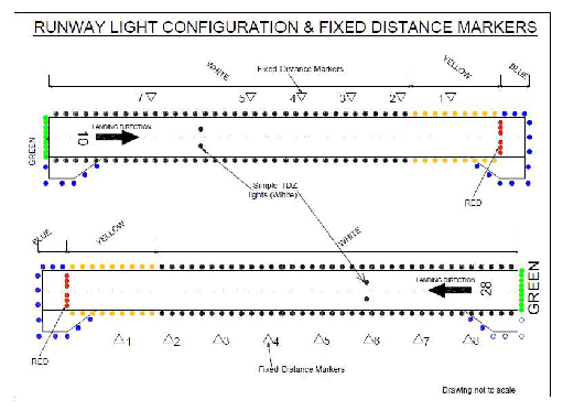
LDI
|
LDI: (Outlined by white lights):225M NW of ARP Abeam (left side) RWY THR 10 & 28, & 2130M from RWY 28 THR.
|
|
Anemometer
|
2320M from THR RWY 28 on northern side of RWY
|
|
3
|
Taxiway edge and taxiway centre line lights;
|
Edge
|
Lighted
|
|
Centre Line
|
Not Lighted
|
|
4
|
Secondary power supply including switch-over time;
|
Secondary power supply to all essential lighting and operational units at AD.
Switch-over time:8 sec APCH/RWY (Primary Circuit), PAPI & all NAV/COM AIDS. Switch over time: Zero.
|
|
5
|
Remarks
|
RWY 28 Lead-in-lighting system: 4 Light units, each consisting of a group of 3 sequential flashing white lights in a linear configuration installed on the FINAL APP.
TRACK, of RWY 28, at a distance of 6193M, 4721M, 3121M, and 1826Mrespectively from THR RWY 28.
Light unit situated at 3121M from THR RWY 28 is offset by 16.5M towards right while approaching of extended RWY centreline. Intensity - 300cd/1500cd/15000cd.
|
|
Stand No.
|
Coordinates
|
Elevation (FT)
|
Bearing Strength & Surface
|
|
1
|
110821.09N 0755655.85E
|
332
|
68/R/A/W/T Cement Concrete
|
|
2
|
110820.84N 0755657.17E
|
333
|
53/R/A/W/T Cement Concrete
|
|
3
|
110820.89N 0755658.55E
|
334
|
53/R/A/W/T Cement Concrete
|
|
4
|
110820.67N 0755700.12E
|
334
|
53/R/A/W/T Cement Concrete
|
|
5
|
110820.35N 0755701.82E
|
334
|
53/R/A/W/T Cement Concrete
|
|
5A
|
110820.48N 0755701.99E
|
333
|
53/R/A/W/T Cement Concrete
|
|
6
|
110820.19N 0755703.30E
|
333
|
53/R/A/W/T Cement Concrete
|
|
7
|
110819.74N 0755704.60E
|
333
|
53/R/A/W/T Cement Concrete
|
|
8
|
110819.52N 0755706.16E
|
333
|
53/R/A/W/T Cement Concrete
|
|
9
|
110819.66N 0755706.32E
|
333
|
68/R/A/W/T Cement Concrete
|
|
10
|
110819.55N 0755708.06E
|
334
|
68/R/A/W/T Cement Concrete
|
|
11
|
110818.65N 0755709.62E
|
334
|
68/R/A/W/T Cement Concrete
|
|
12
|
110818.54N 0755710.99E
|
333
|
68/R/A/W/T Cement Concrete
|
|
12A
|
110818.18N 0755711.28E
|
333
|
68/R/A/W/T Cement Concrete
|
|
13
|
|
110818.17N 0755712.30E
|
332
|
68/R/A/W/T Cement Concrete
|
|
Remark:-
i. Aerobridge with VDGS available for Stands 4, 5, 8, 10, 11 AND 12.
ii. Aerobridge service available for Stands no. 5A, 9 and 12A without VDGS.
iii. For further details refer aircraft Parking/Docking Chart.
|