|
1
|
Aerodrome reference point coordinates and its site
|
314238N 0744801E
MAG. BRG. 345.96° /1653M From Physical Beginning of RWY-34
|
|
2
|
Direction and distance of aerodrome reference point from the center of the city or town which the aerodrome serves
|
325 DEG /11KM from Amritsar
|
|
3
|
Aerodrome elevation and reference temperature
|
760 FT / 40.0 DEG C
|
|
4
|
Magnetic variation, date of information and annual change
|
1.50 DEG E (2010) /0.033 DEG E
|
|
5
|
Name of aerodrome operator, address, telephone, telefax, e-mail address, AFS address, website (if available)
|
Airport Director Airports Authority of India Sri Guru Ram Dass Jee International Airport, Amritsar-143101,
|
|
Telephone:
|
+91-183-2214118 +919464662200
|
|
Fax:
|
+91-183-2214358
|
|
AFS:
|
VIARYHYX
|
|
Email:
|
apdasr@aai.aero
|
|
6
|
Types of traffic permitted (IFR/VFR)
|
IFR/VFR
|
|
7
|
Remarks
|
Elevation in EGM08
|
|
1
|
Designation, surface and strength of aprons
|
Refer Aircraft Parking/Docking Chart
|
|
2
|
Designation, width, surface and strength of
taxiways
|
Refer Aircraft Parking/Docking Chart and AD 2.23
|
|
3
|
Location and elevation of altimeter checkpoints
|
Location At Holding Point of TWY ‘F’ (Coordinate:314214.19N 0744803.77E) Elevation 753.2 FT
|
|
4
|
Location of VOR checkpoints
|
TWY E: 314232.88N 0744754.99E / ELEV 758FT
TWY F: 314215.14N 0744806.44E / ELEV 756FT
|
|
5
|
Position of INS checkpoints
|
NIL
|
|
6
|
Remarks
|
1. Coordinates of Runway Holding Position:
i. TWY C: 314230.58497N 0744748.41049E/ELEV: 754FT
ii. TWY E (CAT-I): 314232.83063N 0744754.86087E/
ELEV: 755FT
iii. TWY E (CAT-II): 314233.68718N 0744757.32778E/
ELEV: 755FT
iv. TWY F(CAT-I): 314214.21651N 0744803.80603E/
ELEV: 753FT
v. TWY F(CAT-II): 314215.09550N 0744806.30009E/
ELEV: 753FT
vi. TWY P: 314158.31089N 0744815.53098E/ELEV: 752FT
2. Coordinates of RWY & Taxi Intersection:
i. TWY F: 314213.13199N 0744800.58800E/ELEV: 757FT
ii. TWY E: 314231.75901N 0744751.59001E/ELEV: 758FT
3. Elevations in EGM08
|
|
1
|
Use of aircraft stand identification signs, taxiway guidelines and visual docking/parking guidance system at aircraft stands
|
Taxiing guidance signs AVBL. Guidelines at Apron. Nose-in Guidance at aircraft stands, VDGS AVBL for parking bays 3 & 5.
|
|
2
|
Runway and taxiway markings and lights
|
RWY
Markings
Designation, Aiming Point, THR, TDZ, Centreline, Edge, Fillet, Side Strip,
Lighting
Centreline, TDZ, THR, RWY edge, RWY end.
TWY
Markings Centreline, Edge, Fillet
Lighting Edge
|
|
3
|
Stop bars (if any)
|
At TWY E, F and P.
|
|
4
|
Remarks
|
Acft Stand Manoeuvring Guidance Lights:-
Avbl On Bay 3,4,5 And 11.
|
|
In Approach/Take-off/Circling Area and at AD
|
|---|
|
1
|
2
|
3
|
4
|
5
|
6
|
|---|
|
RWY/Area affected
|
Obstacle type
|
Coordinates
|
Elevation
(EGM-08)
|
Marking/LGT
|
Remarks
|
|---|
|
34/TKOF
16/APCH
|
ANTENNA
|
314345.7N
0744719.3E
|
783 FT
|
NIL
|
Antenna on LOC Hut (Hut Top 234.9M)
|
|
34/TKOF
16/APCH
|
OTHER
|
314444.8N
0744626.6E
|
928 FT
|
NIL
|
Cell Phone Tower
|
|
34/TKOF
16/APCH
|
TREE
|
314357.7N
0744714.0E
|
812 FT
|
NIL
|
Group of Trees
|
|
34/TKOF
16/APCH
|
TREE
|
314356.4N
0744715.5E
|
814 FT
|
NIL
|
Group of Trees
|
|
34/TKOF
16/APCH
|
TREE
|
314357.4N
0744706.6E
|
828 FT
|
NIL
|
Group of Trees
|
|
34/TKOF
16/APCH
|
TREE
|
314355.6N
0744703.1E
|
823 FT
|
NIL
|
Tree
|
|
34/TKOF
16/APCH
|
TREE
|
314359.3N
0744710.4E
|
818 FT
|
NIL
|
Tree
|
|
34/TKOF
16/APCH
|
TREE
|
314438.3N
0744636.7E
|
914 FT
|
NIL
|
Group of Trees
|
|
34/TKOF
16/APCH
|
TREE
|
314356.4N
0744704.8E
|
822 FT
|
NIL
|
Group of Trees
|
|
34/APCH
16/TKOF
|
FENCE
|
314142.5N
0744818.2E
|
764 FT
|
NIL
|
Airport Boundary Wall Fencing On Top
|
|
34/APCH
16/TKOF
|
TREE
|
314139.8N
0744820.1E
|
779 FT
|
NIL
|
Group of Trees
|
|
34/APCH
16/TKOF
|
TREE
|
314142.2N
0744820.5E
|
777 FT
|
NIL
|
Group of Trees
|
|
34/APCH
16/TKOF
|
TREE
|
314141.8N
0744819.5E
|
778 FT
|
NIL
|
Group of Trees
|
|
34/APCH
16/TKOF
|
TREE
|
314138.9N
0744812.8E
|
782 FT
|
NIL
|
Group of Trees
|
|
34/APCH
16/TKOF
|
POLE
|
314143.9N
0744819.8E
|
768 FT
|
NIL
|
Perimeter Light Pole
|
|
34/APCH
16/TKOF
|
POLE
|
314144.5N
0744820.1E
|
771 FT
|
NIL
|
Perimeter Light Pole
|
|
34/APCH
16/TKOF
|
TREE
|
314124.1N
0744816.7E
|
816 FT
|
NIL
|
Group of Trees
|
|
34/APCH
16/TKOF
|
BUILDING
|
314143.7N
0744819.7E
|
763 FT
|
NIL
|
Security Hut
|
|
34/APCH
16/TKOF
|
BUILDING
|
314140.3N
0744810.4E
|
762 FT
|
NIL
|
Security Hut
|
|
34/APCH
16/TKOF
|
TREE
|
314121.0N
0744820.1E
|
827 FT
|
NIL
|
Group of Trees
|
|
34/APCH
16/TKOF
|
TREE
|
314131.0N
0744816.8E
|
802 FT
|
NIL
|
Tree
|
|
34/APCH
16/TKOF
|
TREE
|
314127.1N
0744817.9E
|
796 FT
|
NIL
|
Group of Trees
|
|
34/APCH
16/TKOF
|
TREE
|
314117.4N
0744838.1E
|
825 FT
|
NIL
|
Group of Trees
|
|
34/APCH
16/TKOF
|
POLE
|
314143.5N
0744819.0E
|
763 FT
|
NIL
|
Perimeter Light Pole
|
|
34/APCH
16/TKOF
|
TREE
|
314101.8N
0744849.1E
|
860 FT
|
NIL
|
Group of Trees
|
|
34/APCH
16/TKOF
|
OTHER
|
314143.2N
0744817.7E
|
769 FT
|
NIL
|
Mobile Road Traffic (Road Elev. 229.5M+5M Mobile
Traffic)
|
|
34/APCH
16/TKOF
|
TREE
|
314135.0N
0744814.1E
|
793 FT
|
NIL
|
Group of Trees
|
|
34/APCH
16/TKOF
|
FENCE
|
314139.8N
0744810.5E
|
763 FT
|
NIL
|
Airport Boundary Wall Fencing On Top
|
|
34/APCH
16/TKOF
|
FENCE
|
314143.8N
0744820.9E
|
765 FT
|
NIL
|
Airport Boundary Wall Fencing On Top
|
|
34/APCH
16/TKOF
|
OTHER
|
314140.7N
0744810.2E
|
771 FT
|
NIL
|
Mobile Road Traffic
(Road Elev.
230.1M+5M Mobile
Traffic)
|
|
34/APCH
16/TKOF
|
OTHER
|
314145.8N
0744819.3E
|
770 FT
|
NIL
|
Mobile Road Traffic
(Road Elev.
229.6M+5M Mobile
Traffic)
|
|
In circling area and at AD
|
BUILDING
|
314334.9N
0744726.9E
|
767 FT
|
NIL
|
Bird Chaser Hut
|
|
In circling area and at AD
|
ANTENNA
|
314328.1N
0744729.1E
|
769 FT
|
NIL
|
MET VRF Antenna
|
|
In circling area and at AD
|
ANTENNA
|
314329.0N
0744728.7E
|
769 FT
|
NIL
|
MET VRF Antenna
|
|
In circling area and at AD
|
ANTENNA
|
314157.3N
0744812.7E
|
761 FT
|
NIL
|
MET VRF Antenna
|
|
In circling area and at AD
|
BUILDING
|
314158.1N
0744812.9E
|
761 FT
|
NIL
|
Bird Chaser Hut
|
|
In circling area and at AD
|
ANTENNA
|
314159.5N
0744811.5E
|
763 FT
|
NIL
|
MET VRF Antenna
|
|
In circling area and at AD
|
ANTENNA
|
314158.6N
0744811.9E
|
763 FT
|
NIL
|
MET VRF Antenna
|
|
In circling area and at AD
|
ANTENNA
|
314159.4N
0744812.1E
|
771 FT
|
NIL
|
Antenna
|
|
In circling area and at AD
|
NAVAID
|
314154.7N
0744814.7E
|
772 FT
|
NIL
|
G.P. Monitor Antenna
|
|
In circling area and at AD
|
NAVAID
|
314157.2N
0744813.5E
|
801 FT
|
NIL
|
G.P. Antenna
|
|
In circling area and at AD
|
NAVAID
|
314157.2N
0744813.3E
|
772 FT
|
NIL
|
G.P./DME Antenna
|
|
In circling area and at AD
|
BUILDING
|
314157.3N
0744813.3E
|
765 FT
|
NIL
|
GP Hut
|
|
In circling area and at AD
|
BUILDING
|
314241.4N
0744752.5E
|
766 FT
|
NIL
|
Structure
|
|
In circling area and at AD
|
ANTENNA
|
314238.0N
0744751.8E
|
764 FT
|
NIL
|
MET VRF Antenna
|
|
In circling area and at AD
|
ANTENNA
|
314239.5N
0744751.3E
|
766 FT
|
NIL
|
MET VRF Antenna
|
|
In circling area and at AD
|
ANTENNA
|
314240.4N
0744750.9E
|
766 FT
|
NIL
|
MET VRF Antenna
|
|
In circling area and at AD
|
BUILDING
|
314308.7N
0744740.9E
|
789 FT
|
NIL
|
Watch Tower
|
|
In circling area and at AD
|
TREE
|
314250.5N
0744728.7E
|
856 FT
|
NIL
|
Tree
|
|
In circling area and at AD
|
ANTENNA
|
314227.4N
0744746.3E
|
790 FT
|
NIL
|
Antenna on Building
|
|
In circling area and at AD
|
OTHER
|
314226.1N
0744747.2E
|
777 FT
|
NIL
|
Wind Direction Indicator
|
|
In circling area and at AD
|
OTHER
|
314337.2N
0744720.0E
|
762 FT
|
NIL
|
APP Light
|
|
In circling area and at AD
|
TREE
|
314336.1N
0744711.3E
|
803 FT
|
NIL
|
Tree
|
|
In circling area and at AD
|
TREE
|
314139.3N
0744827.2E
|
811 FT
|
NIL
|
Tree
|
|
In circling area and at AD
|
POLE
|
314146.8N
0744821.1E
|
784 FT
|
NIL
|
Perimeter Light Pole
|
|
In circling area and at AD
|
POLE
|
314146.5N
0744820.0E
|
784 FT
|
NIL
|
Perimeter Light Pole
|
|
In circling area and at AD
|
POLE
|
314145.0N
0744820.9E
|
784 FT
|
NIL
|
Perimeter Light Pole
|
|
In circling area and at AD
|
POLE
|
314145.3N
0744821.9E
|
784 FT
|
NIL
|
Perimeter Light Pole
|
|
In circling area and at AD
|
POLE
|
314146.3N
0744819.2E
|
765 FT
|
NIL
|
Perimeter Light Pole
|
|
In circling area and at AD
|
TREE
|
314240.6N
0744756.6E
|
818 FT
|
NIL
|
Tree
|
|
In circling area and at AD
|
ANTENNA
|
314241.9N
0744752.4E
|
763 FT
|
NIL
|
MET VRF Antenna
|
|
In circling area and at AD
|
BUILDING
|
314250.2N
0744750.0E
|
790 FT
|
NIL
|
Watch Tower
|
|
In circling area and at AD
|
TREE
|
314252.4N
0744748.3E
|
778 FT
|
NIL
|
Tree
|
|
In circling area and at AD
|
TREE
|
314344.4N
0744726.7E
|
823 FT
|
NIL
|
Tree
|
|
In circling area and at AD
|
OTHER
|
314228.7N
0744749.5E
|
785 FT
|
NIL
|
Wind Direction Indicator
|
|
In circling area and at AD
|
OTHER
|
314340.7N
0744709.8E
|
792 FT
|
NIL
|
Lightning Rod (L)
|
|
In circling area and at AD
|
SIGN
|
314150.8N
0744812.9E
|
757 FT
|
NIL
|
Sign Board
|
|
In circling area and at AD
|
ANTENNA
|
314159.5N
0744811.6E
|
761 FT
|
NIL
|
MET VRF Antenna
|
|
In circling area and at AD
|
OTHER
|
314329.1N
0744728.6E
|
766 FT
|
NIL
|
MET VRF Box
|
|
In circling area and at AD
|
OTHER
|
314324.6N
0744728.7E
|
761 FT
|
NIL
|
PAPI
|
|
In circling area and at AD
|
OTHER
|
314324.3N
0744727.8E
|
761 FT
|
NIL
|
PAPI
|
|
In circling area and at AD
|
OTHER
|
314241.0N
0744749.4E
|
758 FT
|
NIL
|
Elect Circuit Box
|
|
In circling area and at AD
|
SIGN
|
314235.0N
0744751.6E
|
758 FT
|
NIL
|
Sign Board
|
|
In circling area and at AD
|
SIGN
|
314229.4N
0744754.3E
|
759 FT
|
NIL
|
Sign Board
|
|
In circling area and at AD
|
SIGN
|
314216.4N
0744800.5E
|
759 FT
|
NIL
|
Sign Board
|
|
In circling area and at AD
|
SIGN
|
314210.7N
0744803.3E
|
758 FT
|
NIL
|
Sign Board
|
|
In circling area and at AD
|
OTHER
|
314204.8N
0744806.4E
|
759 FT
|
NIL
|
Elect Circuit Box
|
|
In circling area and at AD
|
OTHER
|
314204.4N
0744806.5E
|
759 FT
|
NIL
|
Elect Circuit Box
|
|
In circling area and at AD
|
OTHER
|
314156.4N
0744806.3E
|
756 FT
|
NIL
|
PAPI
|
|
In circling area and at AD
|
OTHER
|
314156.5N
0744806.6E
|
756 FT
|
NIL
|
PAPI
|
|
In circling area and at AD
|
OTHER
|
314156.7N
0744807.0E
|
756 FT
|
NIL
|
PAPI
|
|
In circling area and at AD
|
SIGN
|
314203.4N
0744803.5E
|
760 FT
|
NIL
|
Sign Board
|
|
In circling area and at AD
|
SIGN
|
314213.2N
0744758.9E
|
759 FT
|
NIL
|
Sign Board
|
|
In circling area and at AD
|
SIGN
|
314230.1N
0744750.7E
|
759 FT
|
NIL
|
Sign Board
|
|
In circling area and at AD
|
SIGN
|
314236.1N
0744747.7E
|
759 FT
|
NIL
|
Sign Board
|
|
In circling area and at AD
|
OTHER
|
314240.0N
0744745.9E
|
758 FT
|
NIL
|
Elect Circuit Box
|
|
In circling area and at AD
|
OTHER
|
314240.1N
0744745.9E
|
758 FT
|
NIL
|
Elect Circuit Box
|
|
In circling area and at AD
|
SIGN
|
314243.3N
0744744.4E
|
759 FT
|
NIL
|
Sign Board
|
|
In circling area and at AD
|
SIGN
|
314249.6N
0744741.1E
|
760 FT
|
NIL
|
Sign Board
|
|
In circling area and at AD
|
SIGN
|
314317.0N
0744727.8E
|
761 FT
|
NIL
|
Sign Board
|
|
1
|
Name of the associated meteorological office
|
Amritsar
|
|
2
|
Hours of service and, where applicable, the designation of the responsible meteorological office outside these hours
|
H24
|
|
3
|
Office responsible for preparation of TAFs and periods of validity and interval of issuance of the forecasts
|
Delhi
9Hrs
|
|
4
|
Availability of the trend forecast for the aerodrome and interval of issuance
|
AVBL, issued every half an hour BTN 0800 IST and 2000 IST
|
|
5
|
Information on how briefing and/or consultation is provided
|
AVBL with prior coordination
|
|
6
|
Types of flight documentation supplied and language(s) used in flight documentation
|
Tabular Form (English)
|
|
7
|
Charts and other information displayed or available for briefing or consultation
|
NIL
|
|
8
|
Supplementary equipment available for providing information on meteorological conditions, e.g. weather radar and receiver for satellite images;
|
RVR Transmissometer instrument AVBL at TDZ, MID and end of RWY16/34.
|
|
9
|
The air traffic services unit(s) provided with meteorological information
|
VIAR Amritsar TWR/APP
|
|
10
|
Additional information, e.g. concerning any limitation of service.
|
Class III Met Office. RVR system 'DRISHTI' commissioned at RWY34 end. The system provides RVR data BTN 50M to 2000M. Instrument RVR observation AVBL in ATC tower.
|
Facility
|
Unserviceability
|
Restrictions
|
Arrivals
|
ILS Localizer
|
One transmitter unserviceable
|
Suspend CAT II /CATIIIA / CATIIIB
operations.
|
ILS Glide Path
|
One transmitter unserviceable
|
Suspend CAT II /CATIIIA / CATIIIB
operations.
|
ILS DME
|
One transmitter unserviceable
|
Suspend CAT II /CATIIIA / CATIIIB
operations.
|
RVR System
|
TDZ RVR
|
Suspend CAT II /CATIIIA / CATIIIB
operations.
|
MID RVR
|
Suspend CATIIIA / CATIIIB operations.
|
END RVR
|
Suspend CATIIIA / CATIIIB operations.
|
MID and END RVR
|
Suspend CAT II /CATIIIA / CATIIIB
operations.
|
Stand By Power Supply
lights
|
Generator unserviceable
|
Suspend CAT II /CATIIIA / CATIIIB
operations
|
Stop Bars
|
|
Suspend CATIIIA / CATIIIB
operations
|
Approach
Lights
|
The inner 450 meters- more than 5 % of all lights
|
Suspend CAT II / CATIIIA / CATIIIB
operations
|
Beyond 450 meters more than
15% of all lights
|
Runway Edge
lights
|
More than 5% of all Lights
|
Suspend CAT II / CATIIIA / CATIIIB
operations
|
Two adjacent lamps
|
Runway
Center-line
|
More than 5% of all Lights
|
Suspend CAT II / CATIIIA / CATIIIB
operations
|
Two adjacent lamps
|
Touchdown
Zone lights
|
More than 10% of all Lights
|
Suspend CAT II / CATIIIA / CATIIIB
operations
|
Two lamp in Barrette
|
Threshold
lights
|
More than 5% of all Lights
|
Suspend CAT II / CATIIIA / CATIIIB
operations
|
Two adjacent lamps
|
Runway End
lights
|
More than 25% of all Lights
|
Suspend CAT II / CATIIIA / CATIIIB
operations
|
Two adjacent lamps
|
Taxiway
Centre-line
lights
|
Two adjacent lamps
|
Not applicable to CATII operation
|
Close affected taxiways, use alternate
taxi route.
|
Take-off RVR/Visibility
|
|
Facilities
|
RVR/VIS 1 Cat A, B, C & D
|
Adequate Visual reference 2 (Day only)
|
500 m
|
Runway edge lights or Runway centre line markings 3
|
400 m
|
Runway edge lights and Runway centre line markings 3
|
300 m
|
Runway edge lights and Runway centre line lights
|
200 m
|
Runway edge lights and Runway centre line lights and relevant RVR information 4
|
150 m
|
High intensity Runway edge lights and Runway centre line lights (spacing 15 m or less) and relevant RVR information 4
|
125 m
|
High intensity Runway edge lights and Runway centre line lights (spacing 15 m or less), approved lateral guidance system and relevant RVR information 4
|
75 m
|
Note 1 - The TDZ RVR/VIS may be assessed by the pilot
Note 2 - Adequate Visual reference means, that a pilot is able to continuously identify the take-off surface and maintain
directional control.
Note 3 - For night operations at least runway edge lights or centre line lights and runway end lights are available.
Note 4 - The required RVR must be achieved for all relevant RVR reporting points (touchdown, mid- point and stop-end/
roll-out). The governing RVR shall be the lowest of the reported RVRs
|
2. SOP FOR CONTROL OF RUNWAY CROSSING BY IAF VEHICLES/ PERSONNEL & CROSSING OF
TAXIWAY "G" FOR MOVEMENT TO/FROM GURUDWARA
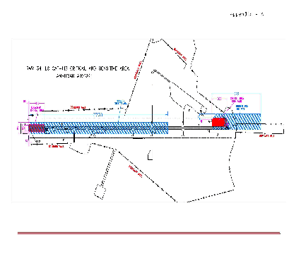
At SGRDJ International Airport, Gurudwara Santsar is located on West of Taxiway "G". To control the movement of devotees to/from gurudwara, the following procedure will be followed:
a) On receipt of information regarding implementation of safeguarding procedures, CISF Control Room will instruct the
CISF guards on duty to coordinate all movement to/from gurudwara with ATC Tower.
b) Crossing of Taxiway "G" shall not be allowed for movement to/from gurudwara unless positively coordinated with ATC
Tower.
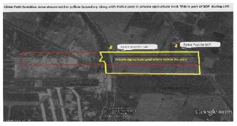
3. SOP FOR CONTROL OF CONSTRUCTION ACTIVITY, ERECTION OF POLES/ LINES, MOVEMENT OF
VEHICLES/ MACHINERY ETC. IN GLIDE PATH SENSITIVE AREA IN AGRICULTURAL LAND OUTSIDE
AAI BOUNDARY WALL
At SGRDJ International Airport, on Eastern side of runway-34, some portion of sensitive area of Glide Path is falling outside AAI boundary wall in the private agricultural land. The Distt. Administration/Local Police will sensitize the owner of the agricultural land about the importance of requirement to protect sensitive area of glide path.
In order to control the movement of vehicles, machinery, erection of electric poles/lines, construction activity etc in this area, the following standard operating procedure is formulated in consultation with Airport Police Station/Distt Administration:
i) Whenever visibility is at or below 1200m, safeguarding procedures are implemented by ATC Tower. As soon as safeguarding procedures are implemented, ATC Tower will intimate Airport Police Station on Tele- 0183- 2214099 or in person in case of no contact on telephone. The Airport Police Station which is located within airport premises will inform the owner of the agricultural land to take out any vehicle/machinery from the earmarked area.
ii) Airport Police Station will position two police guards on the locations marked on enclosed map. They will not allow any vehicle/machinery to enter the glide path sensitive area as shown in the map and ask the owner of the agricultural land to remove any vehicle/machinery present in the sensitive area.
iii) The Police personnel deployed in the sensitive area will intimate ATC Tower of any unauthorized vehicles/machinery in the sensitive area and also confirm to ATC Tower that any vehicle/machinery present in the sensitive area has been removed.
NOTE: - No construction activity or erection of electric poles/lines will be allowed in the sensitive area outside AAI boundary wall by enforcing provisions of Aircraft Act 1934.
GLIDE PATH SENSITIVE AREA OUTSIDE AAI BOUNDARY WALL
|
7. RADIO COMMUNICATION FAILURE PROCEDURES
The Radio Communication Failure procedures established herein are based on the provisions of ICAO PANS ATM DOC 4444. The objective is to standardize the actions to be taken by the pilot of arriving and departing aircraft experiencing radio communication failure at Amritsar airport, when ATS surveillance system is used in the provision of approach control in such airspace and during the periods of non-availability of ATS surveillance system in part or whole of the concerned airspace in Amritsar, the provisions of ICAO PANS ATM DOC 4444 shall be followed:
7.1 General
7.1.1 All Transponder equipped aircraft experiencing Radio Communication Failure shall set transponder to Mode A/C code 7600 as soon as practicable.
(Note: This Requirement of Setting transponder to Mode A/C code 7600 in no way imposes any restriction on the pilot’s decision to set transponder to Mode A/C code 7500 or 7700, whenever required).
7.1.2 An aircraft equipped with other surveillance system transmitters like ADS-B, might indicate the loss of air-ground communication by all of the available means.
7.1.3 Immediately after detection of RCF, the pilot shall try to communicate to the concerned ATS unit through the frequencies of adjacent units/stations, or 121.5 MHz or by relay through other aircraft. The RCF aircraft shall also try to contact the appropriate HF frequencies to relay messages to the concerned ATS unit.
7.1.4 Aircraft shall avoid all Prohibited, Restricted and active Danger Areas. Aircraft shall not enter Pakistan airspace if flight plan does not include Lahore FIR unless emergency conditions warrant so. If aircraft is observed entering any of the areas mentioned above Amritsar ATC unit shall inform the units concerned accordingly.
7.1.5 Pilot shall make blind transmission to ATC of all necessary reports and actions taken by the aircraft, e.g. descent, turn, proceeding to waypoint etc., irrespective of whether partial/ complete RCF has been established or not.
7.2 Assigned Runway and its availability for RCF Aircraft
7.2.1 In case of arriving aircraft experiencing RCF, when Runway for landing has already been advised to the aircraft by ATC, such runway shall be considered as assigned runway. If an arriving aircraft has not been advised of any runway for landing, Runway 34 shall be considered as assigned runway for such arrival.
7.2.2 In case of departures from Amritsar returning on account of RCF, the departure runway of such aircraft shall be considered as assigned runway for landing.
7.2.3 Runway lights and approach lights of the assigned runway in ‘SWITCHED ON’ position shall indicate the availability of such Runway for aircraft experiencing RCF.
7.2.4 Irrespective of day/night/visibility/weather conditions, Runway and Approach lights in ‘SWITCHED OFF’ position shall indicate non-availability of such Runway for aircraft experiencing RCF.
7.2.5 In case strong tail wind conditions are encountered during approach for the assigned Runway, the aircraft experiencing RCF will carry out a missed approach on assigned runway and after following complete missed approach procedure for such approach, aircraft will carry out any of the published instrument approach procedure for the opposite runway.
7.3 Procedure for Arrivals
7.3.1 When an Arriving aircraft is being radar vectored for approach, on experiencing RCF, shall maintain last assigned level and heading for 3 minutes after detecting RCF or selecting MODE A/C 7600, whichever is later and then take a convenient turn to proceed direct to ‘AAR’ VOR/ ‘AR’ NDB descending/maintaining last assigned level, or 2800 FT
|
whichever is higher. (Aircraft shall avoid all Restricted Areas and active Danger Areas. Aircraft shall not enter Pakistan airspace if flight plan does not include Lahore FIR unless emergency conditions warrant so.) If higher, descend to 2800 FT in ‘AAR/AR’ hold. Leave ‘AAR’ VOR/ ‘AR’ NDB at 2800 FT to carry out any of the published instrument approach procedure for assigned runway.
7.3.2 If radio communication failure occurs after the receipt of interception turn of the final approach track or approach clearance, the aircraft may continue its approach to land on such Runway.
7.3.3 If the aircraft has landed on Rwy 16 or Rwy 34, it shall vacate Rwy via Twy F and follow FOLLOW ME jeep to the parking bay.
7.4 Procedure for Departures
7.4.1 Departure aircraft experiencing RCF and intending to continue to destination
7.4.1.1 Departure aircraft experiencing RCF following Radar heading or have been directed by ATC to proceed offset using RNAV without a specified limit, shall Continue on assigned heading climbing to or maintaining cleared level following level restrictions if so specified in ATC clearance. Three minute after setting Mode A/C code 7600 or reaching cleared Flight level whichever is later aircraft shall proceed direct to re-join the current flight plan route not later than the next significant point, maintaining cleared flight level. After joining ATS route, climb to filed Flight level and continue as per the filed flight plan. (Aircraft shall avoid all Prohibited, Restricted and active Danger Areas. Aircraft shall not enter Pakistan airspace if flight plan does not include Lahore FIR unless emergency conditions warrant so.)
7.4.2 Departure aircraft experiencing RCF and intending to land back at Amritsar shall
7.4.2.1 Continue on Radar heading, climbing to or maintaining the cleared Flight level. However, in case the RCF is experienced below FL090 and the cleared flight level is above FL090, aircraft shall maintain FL090
7.4.2.2 Three minutes after setting Mode A/C code 7600 or reaching the appropriate level as given above, whichever is later; take a turn to proceed direct to ‘AAR’ maintaining level.
7.4.2.3 Descend to 2800 FT in ‘AAR’ hold. Leave ‘AAR’ at 2800 FT to carry out any of the published instrument approach procedure for assigned runway.
Note: - In Case of Non-availability of AAR or AR NDB, aircraft can continue instrument approach and land with the help of ILS by using RNAV systems to fly conventional instrument approach procedures up to Final Approach Fix/Point IFAF/FAP)
7.5 Procedure for VFR traffic
7.5.1 In the event of a VFR flight experiencing RCF within the Control Zone of Amritsar, it shall continue to fly in VMC, land at the nearest suitable aerodrome/helicopter point and report its arrival by the most expeditious means to the ATC, Amritsar.
7.6 Various Signals used by ATCO during communication failure
Air Traffic Controllers have Aldis lamp as a backup system for communication if radios fail.
|